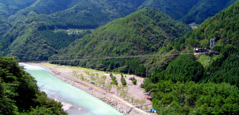
| Tanize Suspension Bridge 谷瀬の吊り橋 | |
|---|---|
 Large Bridge in Totsukawa Large Bridge in Totsukawa | |
| Coordinates | 34°06′05″N 135°45′46″E / 34.10139°N 135.76278°E / 34.10139; 135.76278 |
| Carries | People |
| Crosses | Totsukawa River (Kumano River) |
| Locale | Ueno-tanize Totsukawa Village, Yoshino District, Nara Prefecture |
| Other name(s) | Tanize Line |
| Owner | Totsukawa Village |
| Characteristics | |
| Design | Suspension Bridge |
| Material | Wire cable |
| Total length | 297.7 m (977 ft) |
| Width | 2 m (6 ft 7 in) |
| Height | 54 m (177 ft) |
| History | |
| Construction end | 1954 |
| Construction cost | ¥8,000,000 |
| Location | |
Tanize Suspension Bridge (Japanese: 谷瀬の吊り橋, Hepburn: tanize no tsuribashi), alternatively known as the Tanise Suspension Bridge, is a bridge in Totsukawa, Nara. It is one of Japan's oldest and longest extant wire suspension bridges. The bridge, locally known as 谷瀬大橋 (Tanize-ōhashi, lit. 'tanize great bridge') has a commemorative plaque with 谷瀬橋 (tanize-bashi, lit. 'tanize bridge') engraved onto it.
Overview
The bridge spans the Totsukawa river (Kumano River), and connects Totsukawa village and Tanize (Uenoji), which lies on the other side of the bridge. The bridge is 54 m (177 ft) from the surface of the river and has a deck spanning 297.7 m (977 ft) long. In 1954, the construction of the bridge was finished. At the time of completion, it was the longest steel wire suspension bridge in Japan. In 1994, the Ryuujin Suspension Bridge, located in Ibaraki Prefecture, was completed and acquired the title as longest suspension bridge in Japan.
According to Rom International, prior to the completion of the suspension bridge, every time someone wanted to cross the pass, they had to cross the Totsukawa River, come down through the Tanize Valley, cross a log bridge, and then crawl up a steep slope. If the river flooded, the log bridge would be swept away. The people of the region put together ¥20,000 to ¥30,000 per household, totaling over ¥8 million, and constructed a large suspension bridge with the funds. At the time of the Post war reconstruction, an instructor's starting salary was only ¥7,800 and 10 kilograms of rice was only \765. 80% of the construction costs were paid by the residents, however, the convenience of the new route was long-awaited, and became an icon within the village. Thus, they prohibit crossing the bridge on bicycles and motorcycles, with an exception made for residents, and only allow crossing by foot for tourists.
Formerly, children who attended school in Uenoji used the bride to get to and from school, however, as the school closed in 2010, the suspension bridge became primarily used by tourists.
The center construction of the bridge has roughly 80 cm (31 in) wide planks, and 30 cm (12 in) long, with the planks laid on top of the wires. The river is visible through the wire mesh deck of the bridge. The bridge is said to move considerably if wind blows. The village forbids more than 20 people on the bridge at once due to the danger of a potential collapse if the bridge were to exceed its weight limit. as the bridge attracts heavy tourism. During said periods of heavy tourism, traffic is restricted to one direction, from Uenoji to Tanize and security is present to ensure compliance, because of the potential danger presented by the bridge going over capacity. In the case of their tourism protocols being implemented, access to the bridge is made free, with a paid bus that returns you from the opposite side of the bridge.
On 28 September 2021, it was acknowledged by the Japan Society of Civil Engineers.
Access
Car
Bus
- Nara Kotsu Bus Lines(Yagishingū Line・Totsukawa Line) Uenoji Stop
Gallery

References
- ^ "谷瀬の吊り橋". 十津川村観光協会. Retrieved 2020-08-12.
- ^ 十津川村役場 建設課 (October 2018). "十津川村 橋梁個別施設計画(NO.163)" (PDF). Retrieved 2020-08-12.
- 1868 to 1938: Williamson J., Nominal Wage, Cost of Living, Real Wage and Land Rent Data for Japan 1831-1938, 1939 to 1945: Bank of Japan Historical Statistics Afterwards, Japanese Historical Consumer Price Index numbers based on data available from the Japanese Statistics Bureau. Japan Historical Consumer Price Index (CPI) – 1970 to 2014 Retrieved 30 July 2014. For between 1946 and 1970, from "昭和戦後史". Retrieved 2015-01-24.
- ^ 日本橋梁建設協会監修, ed. (2013). 日本の名橋 完全名鑑. 廣済堂ベストムック217号. 廣済堂出版. pp. 108–109. ISBN 978-4-331-80222-9.
- 日本の歩道吊橋について
- ^ ロム・インターナショナル(編) 2005, p. 79.
- ^ ロム・インターナショナル(編) 2005, p. 78.
- ^ "生活つなぐ 観光名所の村道 谷瀬の吊り橋(奈良県)". 朝日新聞デジタル. 朝日新聞社. 2010-06-04. Retrieved 2020-08-12.
- 平野暉雄 (2007). 橋を見に行こう - 伝えたい日本の橋. 自由国民社. p. 56. ISBN 978-4-426-11146-5.
- 十津川村教育委員会 (2010-06-04). "十津川探検 - 谷瀬のつり橋". 十津川かけはしネット. 十津川村教育機器研究会. Retrieved 2020-08-12.
- "令和三年度土木学会選奨土木遺産が決まりました". 土木学会. 2021-09-28. Retrieved 2021-09-28.
- "令和三年度 土木学会選奨土木遺産 一覧". 土木学会. 2021-09-28. Retrieved 2021-09-28.
Works Cited
- ロム・インターナショナル(編) (2005-02-01). 道路地図 びっくり!博学知識. KAWADE夢文庫. Kawade Shobō Shinsha. ISBN 4-309-49566-4.


