| Tergast | |
|---|---|
| Village of Moormerland | |
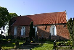
 Church of Tergast Church of Tergast | |
| Location of Tergast | |
  | |
| Coordinates: 53°20′11″N 7°22′11″E / 53.33629°N 7.36961°E / 53.33629; 7.36961 | |
| Country | Germany |
| State | Lower Saxony |
| District | Leer |
| Municipality | Moormerland |
| Area | |
| • Village of Moormerland | 9.95 km (3.84 sq mi) |
| Elevation | 4 m (13 ft) |
| Population | |
| • Metro | 457 |
| Time zone | UTC+01:00 (CET) |
| • Summer (DST) | UTC+02:00 (CEST) |
| Postal codes | 26802 |
| Dialling codes | 04924 |
Tergast is a village in the region of East Frisia, in Lower Saxony, Germany. Administratively, it is an Ortsteil of the municipality of Moormerland. Tergast is 1.5 kilometers to the northeast of Oldersum and has a population of 457.
The first known mention of the village is as Gast in a deed of gift from the Langen monastery in 1401. Its current name could refer to the fact that the village is built on a high sand ridge, known as a geest. The Church of Tergast was built on the highest point of this ridge somewhere in the second half of the 13th century.
The Emden municipal waterworks with several reservoirs is located in Tergast.
Notable people
- Habbo Gerhard Lolling (1848–1894), archaeologist
References
- Euhausen, Klaus. "Tergast, Gemeinde Moormerland, Landkreis Leer" (PDF). Ostfriesisches Landschaft (in German). Retrieved 21 March 2024.
| Villages in the municipality of Moormerland | ||
|---|---|---|
This German location article is a stub. You can help Misplaced Pages by expanding it. |