Human settlement in England
| Underbarrow | |
|---|---|
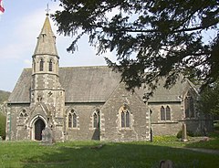
 All Saints Church All Saints Church | |
  | |
| Population | 330 (2011) |
| OS grid reference | SD467921 |
| Civil parish |
|
| Unitary authority | |
| Ceremonial county | |
| Region | |
| Country | England |
| Sovereign state | United Kingdom |
| Post town | Kendal |
| Postcode district | LA8 |
| Dialling code | 01539 |
| Police | Cumbria |
| Fire | Cumbria |
| Ambulance | North West |
| UK Parliament | |
| 54°19′19″N 2°49′12″W / 54.322°N 2.820°W / 54.322; -2.820 | |
Underbarrow is a small village in Cumbria, England, located 3 miles (4.8 km) west of Kendal. The village is in the Lake District National Park. It is in the civil parish of Underbarrow and Bradleyfield, in Westmorland and Furness district, and has a parish council. In the 2001 census Underbarrow and Bradleyfield had a population of 351, decreasing at the 2011 census to 330.
Politics
In 1974 under the Local Government Act 1972 Underbarrow became a part of the South Lakeland district whose administrative centre is Kendal. In 2023 the South Lakeland district was abolished and the town is now part of the Westmorland and Furness district.
Underbarrow is part of the Westmorland and Lonsdale parliamentary constituency for which Tim Farron is the current MP representing the Liberal Democrats.
Famous residents
- Edward Burrough (1634–1663), the Quaker, was born here
See also
References
- ^ UK Census (2011). "Local Area Report – Underbarrow and Bradleyfield Parish (E04002656)". Nomis. Office for National Statistics. Retrieved 14 May 2021.
- "Descriptive Gazetteer Entry for Underbarrow". A Vision of Britain Through Time. University of Portsmouth and others. Retrieved 9 February 2011.
- "Underbarrow and Bradleyfield Parish Council". Underbarrow and Bradleyfield Parish Council. Retrieved 11 March 2016.
- UK Census (2001). "Local Area Report – Underbarrow and Bradleyfield Parish (16UG073)". Nomis. Office for National Statistics. Retrieved 14 May 2021.
- Tim Farron "TheyWorkForYou" listing
External links
- Underbarrow village website
- Cumbria County History Trust: Underbarrow and Bradleyfield (nb: provisional research only – see Talk page)
Location Grid
| Places adjacent to Underbarrow | ||||||||||||||||
|---|---|---|---|---|---|---|---|---|---|---|---|---|---|---|---|---|
| ||||||||||||||||
This Cumbria location article is a stub. You can help Misplaced Pages by expanding it. |