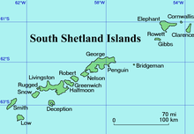

Urda Ridge (Bulgarian: Урдин хребет, ‘Urdin Hrebet’ \'ur-din 'hre-bet\) is the mostly ice-covered ridge occupying the interior of southern Clarence Island in the South Shetland Islands, Antarctica. It extends 8 km in north-northeast to south-southwest direction and 9 km in west-northwest to east-southeast direction, rising to 1950 m at the island's summit Mount Irving, and is connected to Ravelin Ridge to the north by Soyka Saddle. The southeast slopes of the feature are drained by Dobrodan and Highton Glaciers, and its northwest slopes — by Skaplizo, Giridava and Bersame Glaciers. Urda is a Thracian place name from Southern Bulgaria.
Location
Urda Ridge is centred at 61°16′10″S 54°08′00″W / 61.26944°S 54.13333°W / -61.26944; -54.13333. British mapping in 1972 and 2009.
Maps
- British Antarctic Territory. Scale 1:200000 topographic map. DOS 610 Series, Sheet W 61 54. Directorate of Overseas Surveys, Tolworth, UK, 1972.
- South Shetland Islands: Elephant, Clarence and Gibbs Islands. Scale 1:220000 topographic map. UK Antarctic Place-names Committee, 2009.
- Antarctic Digital Database (ADD). Scale 1:250000 topographic map of Antarctica. Scientific Committee on Antarctic Research (SCAR). Since 1993, regularly upgraded and updated.
Notes
- South Shetland Islands: Elephant, Clarence and Gibbs Islands. Archived 2014-12-09 at the Wayback Machine Scale 1:220000 topographic map. UK Antarctic Place-names Committee, 2009.
References
- Bulgarian Antarctic Gazetteer. Antarctic Place-names Commission. (details in Bulgarian, basic data in English)
- Urda Ridge. SCAR Composite Gazetteer of Antarctica
External links
- Urda Ridge. Copernix satellite image
This article includes information from the Antarctic Place-names Commission of Bulgaria which is used with permission.
This Clarence Island (South Shetland Islands) location article is a stub. You can help Misplaced Pages by expanding it. |