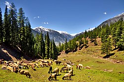
Union council in Khyber Pakhtunkhwa, Pakistan
| Utror | |
|---|---|
| Union council | |
 Utror Valley, in Swat District Utror Valley, in Swat District | |
| Country | |
| Province | Khyber Pakhtunkhwa |
| District | Swat District |
| Tehsil | Behrain Tehsil |
Utror, also spelt Atror, is a valley and a union council of the Behrain Tehsil, located in upper Swat region of Khyber Pakhtunkhwa, Pakistan. It is surrounded by snow-clad mountains, green pastures and waterfalls. The area of the valley is about 47,400 hectares (474 km). Utror is 16 km (9.9 mi) away from Kalam Valley and 116 km (72 mi) from Saidu Sharif. The population of the region is around 20,000.
Utror is surrounded by Bhan valley on the east, Upper Dir District on the west, Kalam on the south and Gabral on the north. The altitude of the valley at Utror proper is 2,300 metres (7,500 ft) and reaches 2,900 metres (9,500 ft) at Kundol Lake. Badogai Pass connects it to Upper Dir District. Further the region leads to Chitral.
See also
References
- Khaliq, Fazal (18 June 2019). "Natural beauty of Utror meadows stuns tourists". Daily Dawn. Retrieved 21 September 2024.
- ^ "Swat villagers bear brunt of devastating flood". Dawn. 29 May 2023. Retrieved 11 October 2024.
- Naveed, Shahzad (21 July 2024). "s Features Citizens' Voice Climate Crisis Videos Fact-check Get Alerts Trekkers Traverse Swat To Raise Awareness On Climate Action". The Friday Times. Retrieved 11 October 2024.
- ^ Hamayun, Muhammad (1 January 2005). "Ethnobotanical Profile of Utror and Gabral Valleys, District Swat, Pakistan". Ethnobotanical Leaflets. 2005 (1).
- "Distance from Kalam and Saidu Sharif". Distancesfrom.com. Retrieved 3 August 2018.
35°29′30″N 72°28′10″E / 35.49167°N 72.46944°E / 35.49167; 72.46944
Categories: