| Vöckla | |
|---|---|
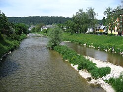
 The Vöckla in Vöcklabruck The Vöckla in Vöcklabruck | |
| Location | |
| Country | Austria |
| State | Upper Austria |
| Physical characteristics | |
| Source | |
| • location | northeast of the Mondsee |
| • coordinates | 47°52′53″N 13°21′51″E / 47.8814°N 13.3641°E / 47.8814; 13.3641 |
| Mouth | |
| • location | in Vöcklabruck into the Ager |
| • coordinates | 48°00′04″N 13°40′18″E / 48.0011°N 13.6717°E / 48.0011; 13.6717 |
| Length | 47.2 km (29.3 mi) |
| Basin features | |
| Progression | Ager→ Traun→ Danube→ Black Sea |
The Vöckla is a river in Upper Austria.
The Vöckla has a length of 47 km (29 mi), its basin is about 450 km (170 sq mi), the medium flux 8.7 m/s (310 cu ft/s). The Vöckla originates northeast of the Mondsee. Created by several springs, the river flows in northern direction first. At Frankenmarkt the direction changes to the East, where it passes through Vöcklamarkt, Timelkam, where it is joined by the Dürre Ager, and finally Vöcklabruck, where it discharges into the Ager.
References
- DORIS Atlas (Upper Austria)
- "Vöckla source" (Map). Google Maps. Retrieved 9 February 2020.
- "Dürre Ager mouth" (Map). Google Maps. Retrieved 9 February 2020.
- "Vöckla mouth" (Map). Google Maps. Retrieved 9 February 2020.
External links
- [REDACTED] Media related to Vöckla at Wikimedia Commons
This article related to a river in Austria is a stub. You can help Misplaced Pages by expanding it. |
This Upper Austria location article is a stub. You can help Misplaced Pages by expanding it. |