Place in Louisiana, United States
| Vacherie | |
|---|---|
| Unincorporated community | |
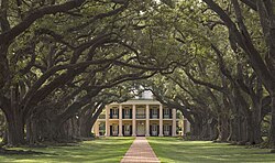
 The Oak Alley Plantation house, built in 1839 The Oak Alley Plantation house, built in 1839 | |
 | |
| Coordinates: 30°00′40″N 90°43′10″W / 30.01111°N 90.71944°W / 30.01111; -90.71944 | |
| Country | |
| State | |
| Parish | St. James |
| Elevation | 5 m (16 ft) |
| Population | |
| • Total | 5,481 |
| Time zone | UTC-6 (CST) |
| • Summer (DST) | UTC-5 (CDT) |
| Area code | 225 |
Vacherie is an unincorporated community in St. James Parish, Louisiana, United States. It is part of the New Orleans Metropolitan Area. The name of the place derives from the French word for cowshed. On the SW side of the community used to be the 1,969 ft (600 m) WZRH/KVDU-Tower, a guyed mast noted as the tallest tower in the state of Louisiana. It fell in 2021 after being damaged by Hurricane Ida.
The best known location in the community is the Oak Alley Plantation. There are several other historic plantations in the area: Laura, Desire, St. Joseph, and Felicity. The last two were combined in 1890.
Vacherie was used as a filming location for the TV series True Detective.
Census-designated places
Vacherie is split into two census-designated places, North Vacherie and South Vacherie, by the United States Census Bureau. As of the 2020 census, North Vacherie had a population of 2,093 and South Vacherie had a population of 3,388.
Education
St. James Parish Public Schools operates public schools. St. James High School is located in Vacherie. Vacherie Elementary School in South Vacherie serves the community.
Notable people
- Valcour Aime, planter and plantation owner
- Alcée Fortier, philologist and folklorist
- George T. Oubre, state senator
- H. H. Richardson, architect
- Corey Webster, football player for the New York Giants
- Alfred C. Williams, state representative for East Baton Rouge Parish
References
- "True Detective Tree location in Vacherie, LA". Virtual Globetrotting. 28 February 2014.
- "Explore Census Data". data.census.gov. Retrieved 12 May 2024.
- "Explore Census Data". data.census.gov. Retrieved 12 May 2024.
- Home. Vacherie Elementary School. Retrieved on 14 February 2017. "13440 Highway 644 Vacherie LA 70090"
- "2010 CENSUS - CENSUS BLOCK MAP: South Vacherie CDP, LA." U.S. Census Bureau. Retrieved on 13 February 2017.
- Thomas, Susan (23 December 2012). "Climbing the Branches of My Family Tree: SUNDAY'S OBITUARY - Francois Gabriel Valcour Aime (1797-1867)". Climbing the Branches of My Family Tree. Retrieved 12 May 2024.
- "Wayback Machine". 8 August 2014. Archived from the original on 8 August 2014. Retrieved 12 May 2024.
- "Membership in the Louisiana State Senate, 1880-Present" (PDF). senate.la.gov. Retrieved 2 January 2014.
- "Henry Hobson Richardson Paintings, Bio, Ideas". The Art Story. Retrieved 12 May 2024.
- "Alfred C. Williams". intelius.com. Retrieved 24 April 2015.
| Municipalities and communities of St. James Parish, Louisiana, United States | ||
|---|---|---|
| Parish seat: Convent | ||
| Towns |  | |
| CDPs | ||
| Unincorporated community | ||
| Footnotes | ‡This populated place also has portions in an adjacent parish or parishes | |
This Louisiana state location article is a stub. You can help Misplaced Pages by expanding it. |