| Velika Popina Велика Попина (Serbian) | |
|---|---|
| Village | |
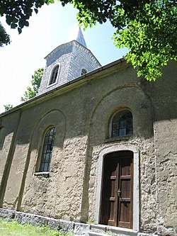
 The Saint Ilija Serbian Orthodox Church in Velika Popina The Saint Ilija Serbian Orthodox Church in Velika Popina | |
 | |
| Coordinates: 44°17′16″N 16°01′57″E / 44.28778°N 16.03250°E / 44.28778; 16.03250 | |
| Country | |
| County | Zadar |
| Municipality | Gračac |
| Area | |
| • Total | 19.4 sq mi (50.2 km) |
| Population | |
| • Total | 42 |
| • Density | 2.2/sq mi (0.84/km) |
| Time zone | UTC+1 (CET) |
| • Summer (DST) | UTC+2 (CEST) |
Velika Popina (Serbian Cyrillic: Велика Попина) is a village in Croatia. The settlement is administered as a part of Gračac municipality, Zadar County.
Population/Demographics
According to national census of 2011, population of the settlement is 71. The majority of the population are Serbs. This represents 20.17% of its pre-war population according to the 1991 census.
The 1991 census recorded that 95.17% of the village population were ethnic Serbs (335/352), 0.28% were Yugoslavs (1/352) while 4.54% were unknown (16/352).
Historical population 1857-2011| population | 1178 | 1586 | 1137 | 1218 | 1385 | 1373 | 1552 | 1518 | 1144 | 1074 | 921 | 710 | 435 | 352 | 53 | 71 |
| 1857 | 1869 | 1880 | 1890 | 1900 | 1910 | 1921 | 1931 | 1948 | 1953 | 1961 | 1971 | 1981 | 1991 | 2001 | 2011 |
References
- Government of Croatia (October 2013). "Peto izvješće Republike Hrvatske o primjeni Europske povelje o regionalnim ili manjinskim jezicima" (PDF) (in Croatian). Council of Europe. p. 36. Retrieved 30 November 2016.
- Register of spatial units of the State Geodetic Administration of the Republic of Croatia. Wikidata Q119585703.
- "Population by Age and Sex, by Settlements" (xlsx). Census of Population, Households and Dwellings in 2021. Zagreb: Croatian Bureau of Statistics. 2022.
- "2011 census by settlement". Central Bureau of Statistics (Croatia) (in Croatian). 2011. Retrieved September 8, 2014.
- "Kakav nam je put, takav nam je i život". portalnovosti.com (in Croatian). 28 July 2018. Retrieved 30 July 2018.
- Izdanje Državnog zavoda za statistiku RH: Narodnosni sastav stanovništva RH od 1880-1991. godine.
- "Population by Age and Sex, by Settlements, 2011 Census: Velika Popina". Census of Population, Households and Dwellings 2011. Zagreb: Croatian Bureau of Statistics. December 2012.
- Naselja i stanovništvo Republike Hrvatske 1857-2001, www.dzs.hr
44°17′N 16°02′E / 44.283°N 16.033°E / 44.283; 16.033
| Municipality of Gračac | |
|---|---|
| Settlements |
|
| Former settlements |
|
This Zadar County geography article is a stub. You can help Misplaced Pages by expanding it. |