| Vintířov | |
|---|---|
| Municipality | |
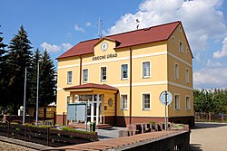
 Municipal office Municipal office | |
 Flag Flag Coat of arms Coat of arms | |
 | |
| Coordinates: 50°14′4″N 12°42′59″E / 50.23444°N 12.71639°E / 50.23444; 12.71639 | |
| Country | |
| Region | Karlovy Vary |
| District | Sokolov |
| First mentioned | 1488 |
| Area | |
| • Total | 14.36 km (5.54 sq mi) |
| Elevation | 448 m (1,470 ft) |
| Population | |
| • Total | 1,232 |
| • Density | 86/km (220/sq mi) |
| Time zone | UTC+1 (CET) |
| • Summer (DST) | UTC+2 (CEST) |
| Postal code | 357 44 |
| Website | www |
Vintířov (German: Wintersgrün) is a municipality and village in Sokolov District in the Karlovy Vary Region of the Czech Republic. It has about 1,200 inhabitants.
Geography
Vintířov is located about 8 kilometres (5 mi) northeast of Sokolov and 9 km (6 mi) west of Karlovy Vary. It lies mostly in the Sokolov Basin, only the northwestern part of the municipal territory extends into the Ore Mountains. The highest point is at 561 m (1,841 ft) above sea level. The brook of Vintířovský potok flows through the municipality. There are several small fishponds in the territory.
History
The first written mention of Vintířov is from 1488. In 1523–1525, it was documented as a property of Sebastian Thüssel of Taltitz. From 1562, it was managed by the town of Loket and from 1598 Loket owned the village. As a result of the Bohemian Revolt, the properties of Loket were confiscated by Emperor Ferdinand II in 1623 and Vintířov was bought by Maria Magdalena Hertel of Leuttersdorf as a part of the Lipnice estate.
For centuries, Vintířov was an agricultural village. In the 19th century, mining of lignite and ceramic clay developed here. Work in the mines and the porcelain factory led to an increase in the population. In 1971, the municipalities of Lipnice and Dolní Rozmyšl were annexed to Vintířov and these two villages were demolished due to the expansion of lignite mining.
After World War II, the German population was expelled.
Demographics
|
|
| ||||||||||||||||||||||||||||||||||||||||||||||||||||||
| Source: Censuses | ||||||||||||||||||||||||||||||||||||||||||||||||||||||||
Economy
The area of Vintířov is known for lignite mining.
Transport
Apart from the industrial spur from the mines, there are no railways or major roads passing through the municipality.
Sights

Vintířov is poor in monuments. The only protected cultural monuments are two rural half-timbered houses from the first half of the 19th century.
In the centre of Vintířov is the Chapel of Saint Anne. It was built in the pseudo-Gothic style in 1906.
References
- "Population of Municipalities – 1 January 2024". Czech Statistical Office. 2024-05-17.
- ^ "Historie obce Vintířov" (in Czech). Obec Vintířov. Retrieved 2023-12-12.
- "Bývalí obyvatelé Lipnice vzpomínali na obec, která ustoupila těžbě uhlí" (in Czech). iDNES.cz. 2013-09-24. Retrieved 2023-12-12.
- "Historický lexikon obcí České republiky 1869–2011" (in Czech). Czech Statistical Office. 2015-12-21.
- "Population Census 2021: Population by sex". Public Database. Czech Statistical Office. 2021-03-27.
- "Výsledky vyhledávání: Kulturní památky, obec Vintířov". Ústřední seznam kulturních památek (in Czech). National Heritage Institute. Retrieved 2024-08-27.
- "Vintířov – kaple sv. Anny". Památky a příroda Karlovarska (in Czech). Retrieved 2023-12-12.
External links