| Wando River | |
|---|---|
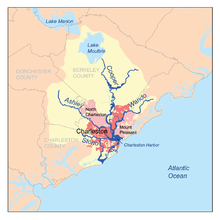
 Map of the Charleston Harbor watershed showing Wando River Map of the Charleston Harbor watershed showing Wando River | |
 | |
| Location | |
| Country | United States |
| State | South Carolina |
| Physical characteristics | |
| Mouth | |
| • coordinates | 32°48′58″N 79°54′40″W / 32.81611°N 79.91111°W / 32.81611; -79.91111 |
The Wando River is a tidewater river in the coastal area of South Carolina. It begins in the town of Awendaw, Charleston County, and has its mouth at the Cooper River shortly before it flows into Charleston Harbor. The Wando's drainage area is 73,061 acres (295.67 km). Nearby Drum Island is uninhabited. It is spanned by the bridges crossing the Wando River and Towne creek.
The river was named for the Wando people, a band of the Cusabo.
References
- Proposed Daniel Island Marine Cargo Terminal, Charleston: 1999 -"A sedimentation problem presently exists near the Drum Island/Wando River Reach intersection which field data have shown to be associated with an eddy attached to the north end of Drum Island."
- U.S. Geological Survey Geographic Names Information System: Wando River
- Swanton, John Reed (1922). Early History of the Creek Indians and Their Neighbors. Washington, DC: US Government Printing Office. p. 23. ISBN 9781404740730.
This article related to a river in South Carolina is a stub. You can help Misplaced Pages by expanding it. |