Census-designated place in Virginia, United States
| Wattsville, Virginia | |
|---|---|
| Census-designated place | |
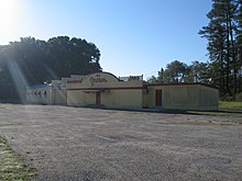
 Businesses in Wattsville, July 2018 Businesses in Wattsville, July 2018 | |
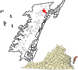
 Location in Accomack County and the state of Virginia. Location in Accomack County and the state of Virginia. | |
| Coordinates: 37°55′48″N 75°29′40″W / 37.93000°N 75.49444°W / 37.93000; -75.49444 | |
| Country | United States |
| State | Virginia |
| County | Accomack |
| Elevation | 3 ft (0.9 m) |
| Population | |
| • Total | 1,341 |
| Time zone | UTC−5 (Eastern (EST)) |
| • Summer (DST) | UTC−4 (EDT) |
| FIPS code | 51-48776 |
| GNIS feature ID | 2584935 |
Wattsville is a census-designated place (CDP) in Accomack County, Virginia, United States. It was first listed as a CDP in 2010. As of the 2020 census, it had a population of 1,341.
Geography
It lies at an elevation of 3 feet.
Demographics
| Census | Pop. | Note | %± |
|---|---|---|---|
| 2010 | 1,128 | — | |
| 2020 | 1,341 | 18.9% | |
| U.S. Decennial Census 2010 2020 | |||
2020 census
| Race / Ethnicity (NH = Non-Hispanic) | Pop 2010 | Pop 2020 | % 2010 | % 2020 |
|---|---|---|---|---|
| White alone (NH) | 723 | 832 | 64.10% | 62.04% |
| Black or African American alone (NH) | 313 | 356 | 27.75% | 26.55% |
| Native American or Alaska Native alone (NH) | 5 | 6 | 0.44% | 0.45% |
| Asian alone (NH) | 12 | 11 | 1.06% | 0.82% |
| Pacific Islander alone (NH) | 3 | 0 | 0.27% | 0.00% |
| Some Other Race alone (NH) | 2 | 7 | 0.18% | 0.52% |
| Mixed Race or Multi-Racial (NH) | 29 | 54 | 2.57% | 4.03% |
| Hispanic or Latino (any race) | 41 | 75 | 3.63% | 5.59% |
| Total | 1,128 | 1,341 | 100.00% | 100.00% |

Transportation
Major highways
Public transportation
STAR Transit provides public transit services, linking Wattsville with Onley, Oak Hall, and other communities in Accomack and Northampton counties on the Eastern Shore.
References
- ^ "Wattsville Census Designated Place". Geographic Names Information System. United States Geological Survey, United States Department of the Interior.
- "Wattsville CDP, Virginia". United States Census Bureau. Archived from the original on February 5, 2023. Retrieved December 25, 2022.
- "Decennial Census by Decade". US Census Bureau. Archived from the original on July 6, 2022.
- ^ "P2 Hispanic or Latino, and Not Hispanic or Latino by Race – 2010: DEC Redistricting Data (PL 94-171) - Wattsville CDP, Virginia". United States Census Bureau. Archived from the original on February 5, 2023. Retrieved February 5, 2023.
- ^ "P2 Hispanic or Latino, and Not Hispanic or Latino by Race – 2020: DEC Redistricting Data (PL 94-171) - Wattsville CDP, Virginia". United States Census Bureau. Archived from the original on February 5, 2023. Retrieved February 5, 2023.
This Accomack County, Virginia state location article is a stub. You can help Misplaced Pages by expanding it. |
