Map all coordinates using OpenStreetMap
Download coordinates as:
Suburb of Toowoomba Region, Queensland, Australia| Whichello Queensland | |||||||||||||||
|---|---|---|---|---|---|---|---|---|---|---|---|---|---|---|---|
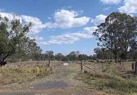
 Paddock along Pechey Maclagan Road, 2014 Paddock along Pechey Maclagan Road, 2014 | |||||||||||||||
 | |||||||||||||||
| Coordinates | 27°17′39″S 151°59′53″E / 27.2941°S 151.9980°E / -27.2941; 151.9980 (Whichello (centre of locality)) | ||||||||||||||
| Population | 31 (2021 census) | ||||||||||||||
| • Density | 2.65/km (6.86/sq mi) | ||||||||||||||
| Postcode(s) | 4352 | ||||||||||||||
| Area | 11.7 km (4.5 sq mi) | ||||||||||||||
| Time zone | AEST (UTC+10:00) | ||||||||||||||
| Location |
| ||||||||||||||
| LGA(s) | Toowoomba Region | ||||||||||||||
| State electorate(s) | Condamine | ||||||||||||||
| Federal division(s) | Maranoa | ||||||||||||||
| |||||||||||||||
Whichello is a rural locality in the Toowoomba Region, Queensland, Australia. In the 2021 census, Whichello had a population of 31 people.
Geography

Whichello is on the Darling Downs in southern Queensland. It is bounded to the north-east by the Great Dividing Range.
The terrain ranges from 560 to 75 metres (1,837 to 246 ft) above sea level. The land use is predominantly grazing on native vegetation with some crop growing.
The Pechey-Maclagan Road runs through from east (Pechey) to south (Groomsville).
History

Whichello Provisional School opened on 18 April 1894. On 1 January 1909, it became Whichello State School. It closed on 22 January 1942. It was on a 5-acre (2.0 ha) site on the northern side of Whichello School Road (27°17′32″S 152°00′39″E / 27.29223°S 152.01097°E / -27.29223; 152.01097 (Whichello State School (former))). The site is now a park.
Whichello Methodist Church opened in March 1907. It was on a 1-acre (0.40 ha) on the northern side of Whichello School Road (27°17′35″S 152°00′51″E / 27.29296°S 152.01425°E / -27.29296; 152.01425 (Whichello Methodist Church (former))), appox 325 metres (1,066 ft) east of the school. The timber church could seat 50 people. In 1952, the church building was relocated to Wilsonton.
Demographics
In the 2016 census, Whichello had a population of 31 people.
In the 2021 census, Whichello had a population of 31 people.
Education
There are no schools in Whichello. The nearest government primary schools are Crows Nest State School in neighbouring Crows Nest to the north-east and Goombungee State School in Goombungee to the south-west. The nearest government secondary schools are Crows Nest State School (to Year 10) and Highfields State Secondary College (to Year 12) in Highfields to the south.
References
- ^ Australian Bureau of Statistics (28 June 2022). "Whichello (SAL)". 2021 Census QuickStats. Retrieved 28 February 2023.

- "Whichello – locality in Toowoomba Region (entry 48094)". Queensland Place Names. Queensland Government. Retrieved 17 November 2019.
- "Layers: Locality; Mountains and ranges; Contours; Watercourses". Queensland Globe. Queensland Government. Archived from the original on 19 December 2017. Retrieved 13 March 2024.
- "Layers: Locality; Protected areas and forests; Land use". Queensland Globe. Queensland Government. Archived from the original on 19 December 2017. Retrieved 13 March 2024.
- Whichello, Queensland (Map). OpenStreetMap. Archived from the original on 28 March 2022. Retrieved 28 March 2022.
- Queensland Family History Society (2010), Queensland schools past and present (Version 1.01 ed.), Queensland Family History Society, ISBN 978-1-921171-26-0
- "Agency ID 9273, Whichello State School". Queensland State Archives. Retrieved 24 September 2023.
- ^ "Crows Nest" (Map). Queensland Government. 1945. Archived from the original on 23 September 2023. Retrieved 24 September 2023.
- ^ "Parish of Douglas" (Map). Queensland Government. 1951. Archived from the original on 23 September 2023. Retrieved 24 September 2023.
- "Queensland Globe". State of Queensland. Retrieved 24 September 2023.
- "DOWNS NEWS". Darling Downs Gazette. Vol. XLIX, no. 7, 969. Queensland, Australia. 23 March 1907. p. 7. Archived from the original on 13 March 2024. Retrieved 24 September 2023 – via National Library of Australia.
- "Whichello Methodist Church | Whichello". Queensland Religious Places Database. Archived from the original on 13 March 2024. Retrieved 13 March 2024.
- Australian Bureau of Statistics (27 June 2017). "Whichello (SSC)". 2016 Census QuickStats. Retrieved 20 October 2018.

- "Layers: Locality; Schools and school catchments". Queensland Globe. Queensland Government. Archived from the original on 19 December 2017. Retrieved 13 March 2024.