 Size of this preview: 618 × 600 pixels. Other resolutions: 247 × 240 pixels | 495 × 480 pixels | 792 × 768 pixels | 1,144 × 1,110 pixels.
Original file (1,144 × 1,110 pixels, file size: 239 KB, MIME type: image/jpeg)
| This is a file from the Wikimedia Commons. Information from its description page there is shown below. Commons is a freely licensed media file repository. You can help. |
Summary
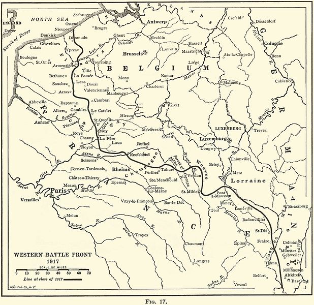
| DescriptionWesternFront1917.jpg | Map of The Western Front in 1917. |
| Date | |
| Source |
THE GEOGRAPHY OF THE GREAT WAR BY FRANK M. McMURRY, PH.D. New York THE MACMILLAN CO. 1919
Image tidied up by Lhgodoy 9 March 2006. |
| Author | FRANK M. McMURRY, PH.D. |
Licensing
| Public domainPublic domainfalsefalse |
| This media file is in the public domain in the United States. This applies to U.S. works where the copyright has expired, often because its first publication occurred prior to January 1, 1930, and if not then due to lack of notice or renewal. See this page for further explanation.
|
||
| This image might not be in the public domain outside of the United States; this especially applies in the countries and areas that do not apply the rule of the shorter term for US works, such as Canada, Mainland China (not Hong Kong or Macao), Germany, Mexico, and Switzerland. The creator and year of publication are essential information and must be provided. See Misplaced Pages:Public domain and Misplaced Pages:Copyrights for more details. |
Captions
Add a one-line explanation of what this file representsItems portrayed in this file
depicts
inception<\/a>"}},"text\/plain":{"en":{"":"inception"}}},"{\"value\":{\"time\":\"+1999-00-00T00:00:00Z\",\"timezone\":0,\"before\":0,\"after\":0,\"precision\":9,\"calendarmodel\":\"http:\\\/\\\/www.wikidata.org\\\/entity\\\/Q1985727\"},\"type\":\"time\"}":{"text\/html":{"en":{"P571":"1999"}},"text\/plain":{"en":{"P571":"1999"}}}}">inception
1999
media type<\/a>"}},"text\/plain":{"en":{"":"media type"}}},"{\"value\":\"image\\\/jpeg\",\"type\":\"string\"}":{"text\/html":{"en":{"P1163":"image\/jpeg"}},"text\/plain":{"en":{"P1163":"image\/jpeg"}}}}">media type
image/jpeg
File history
Click on a date/time to view the file as it appeared at that time.
| Date/Time | Thumbnail | Dimensions | User | Comment | |
|---|---|---|---|---|---|
| current | 07:53, 6 November 2007 |  | 1,144 × 1,110 (239 KB) | Rcbutcher | {{Information |Description=Map of The Western Front in 1917. |Source=THE GEOGRAPHY OF THE GREAT WAR BY FRANK M. McMURRY, PH.D. New York THE MACMILLAN CO. 1919 <br>Provided with the kind permission of Ms. Darlene McClendon at http://freepages.military.root |
File usage
No pages on the English Misplaced Pages use this file (pages on other projects are not listed).Global file usage
The following other wikis use this file:
- Usage on ar.wikipedia.org
- Usage on en.wikinews.org
- Usage on eo.wikipedia.org
- Usage on fi.wikipedia.org
- Usage on he.wikipedia.org
- Usage on id.wikipedia.org
- Usage on it.wikipedia.org
- Usage on ja.wikipedia.org
- Usage on pt.wikipedia.org
- Usage on sr.wikipedia.org
- Usage on sv.wikipedia.org
- Usage on tr.wikipedia.org
- Usage on vi.wikipedia.org
- Usage on zh.wikipedia.org
Metadata
This file contains additional information, probably added from the digital camera or scanner used to create or digitize it.
If the file has been modified from its original state, some details may not fully reflect the modified file.
| _error | 0 |
|---|


