| Revision as of 13:26, 20 August 2012 editSamar (talk | contribs)Autopatrolled, Pending changes reviewers, Rollbackers6,865 edits Coordinates← Previous edit | Latest revision as of 20:52, 31 October 2024 edit undoMonkbot (talk | contribs)Bots3,695,952 editsm Task 20: replace {lang-??} templates with {langx|??} ‹See Tfd› (Replaced 1);Tag: AWB | ||
| (12 intermediate revisions by 10 users not shown) | |||
| Line 1: | Line 1: | ||
| {{Infobox mountain | {{Infobox mountain | ||
| | name =Silberzacken | | name =Silberzacken<br /> | ||
| {{nq|سِلبَرزاکِن}} | |||
| | photo = Nanga Parbat north annotated.png | | photo = Nanga Parbat north annotated.png | ||
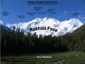
| | photo_caption = The Rakhiot face of the mountain showing Silberzacken and other peaks. | | photo_caption = The Rakhiot face of the mountain showing Silberzacken and other peaks. | ||
| Line 10: | Line 11: | ||
| | location = ], ] | | location = ], ] | ||
| | range = ] | | range = ] | ||
| | map = Pakistan |
| map = Pakistan | ||
| | range_coordinates = | |||
| | map_caption = Location in Pakistan | | map_caption = Location in Pakistan | ||
| | map_size = 250 | | map_size = 250 | ||
| | label_position = right | | label_position = right | ||
| | coordinates = {{coord|35|15|48|N|74|36|28|E|type:mountain_region:PK-NA_scale:100000|format=dms|display=inline,title}} | |||
| | lat_d = 35 | lat_m = 15 | lat_s = 48 | lat_NS = N | |||
| | long_d = 74 | long_m = 36 | long_s = 28 | long_EW = E | |||
| | coordinates_ref = | | coordinates_ref = | ||
| | topo = | | topo = | ||
| Line 24: | Line 25: | ||
| }} | }} | ||
| '''Silberzacken''', also known as '''East Peak''', is a {{convert|7597|m|ft}} high subsidiary peak of ] in the ] in ]. | '''Silberzacken''' ({{langx|ur|{{nq|سلبرزاکن}}}}), also known as '''East Peak''', is a {{convert|7597|m|ft}} high subsidiary peak of ] in the ] in ]. | ||
| ==Location and |
==Location and layout== | ||
| Silberzacken is located on a ridge in ], south of the ] in the ] of ] in Pakistan. The ridge has three faces; Diamir, Rakhiot, and Rupal. The south and southeast side of the mountain is dominated by the Rupal face, while the north and northwest side of the mountain is split into Diamir face in the west and Rakhiot face in the north. | Silberzacken is located on a ridge in ], south of the ] in the ] of ] in Pakistan. The ridge has three faces; Diamir, Rakhiot, and Rupal. The south and southeast side of the mountain is dominated by the ], while the north and northwest side of the mountain is split into Diamir face in the west and Rakhiot face in the north. | ||
| ==See also== | ==See also== | ||
| Line 35: | Line 36: | ||
| {{Reflist}} | {{Reflist}} | ||
| ] | ] | ||
| ] | ] | ||
Latest revision as of 20:52, 31 October 2024
| Silberzacken سِلبَرزاکِن | |
|---|---|
 The Rakhiot face of the mountain showing Silberzacken and other peaks. The Rakhiot face of the mountain showing Silberzacken and other peaks. | |
| Highest point | |
| Elevation | 7,597 m (24,925 ft) |
| Coordinates | 35°15′48″N 74°36′28″E / 35.26333°N 74.60778°E / 35.26333; 74.60778 |
| Geography | |
 سِلبَرزاکِنLocation in Pakistan | |
| Location | Gilgit-Baltistan, Pakistan |
| Parent range | Himalaya |
| Climbing | |
| First ascent | Unclimbed |
Silberzacken (Urdu: سلبرزاکن), also known as East Peak, is a 7,597 metres (24,925 ft) high subsidiary peak of Nanga Parbat in the Himalayan Range in Pakistan.
Location and layout
Silberzacken is located on a ridge in Himalayan Range, south of the Indus River in the Diamer District of Gilgit–Baltistan in Pakistan. The ridge has three faces; Diamir, Rakhiot, and Rupal. The south and southeast side of the mountain is dominated by the Rupal face, while the north and northwest side of the mountain is split into Diamir face in the west and Rakhiot face in the north.