| Revision as of 01:43, 14 December 2007 edit5ju989nfhs50 (talk | contribs)7,497 editsm removed incorrect statement (West Peak, not East Peak, is the highest point w/in 25 miles of the ocean south of Maine.← Previous edit | Latest revision as of 18:56, 5 January 2025 edit undoSer Amantio di Nicolao (talk | contribs)Autopatrolled, Administrators6,286,286 editsm →top: add {{Use mdy dates|date=January 2025}}Tag: AWB | ||
| (38 intermediate revisions by 24 users not shown) | |||
| Line 1: | Line 1: | ||
| {{short description|Mountain in Connecticut, US}} | |||
| ] | |||
| {{Use mdy dates|date=January 2025}} | |||
| :''Should not be confused with ], another traprock summit in Connecticut'' | |||
| {{Infobox mountain | |||
| | name = East Peak | |||
| | photo =East_Peak_Hanging_Hills.jpg | |||
| | photo_caption = View from East Peak. | |||
| | elevation_ft = 976 | |||
| | elevation_ref = | |||
| | prominence = | |||
| | parent_peak = | |||
| | listing = | |||
| | location = ] | |||
| | range = ] / ] | |||
| | coordinates = {{coord|41|33|27|N|72|50|14|W |type:mountain_region:US |display=inline,title}} | |||
| | topo = | |||
| | type = ]; ] | |||
| | age = 200 million yrs. | |||
| | volcanic_arc/belt = | |||
| | last_eruption = | |||
| | first_ascent = | |||
| | easiest_route = Auto road | |||
| }} | |||
| __NOTOC__ | |||
| '''East Peak''', {{convert|976|ft|m|0}}, is a prominent ] ] in the ] of ]. Rugged and scenic, the peak rises steeply above the city of Meriden {{convert|600|ft|m|0}} below and is characterized by its vertical cliffs and sweeping views of southern ] and ]. A small stone observation tower known as ] stands on the summit. | |||
| East Peak is located within the {{convert|1800|acre|km2|adj=on}} ]. The {{convert|51|mi|km|adj=on}} ] crosses East Peak, and a seasonal auto road climbs to a small parking lot at Castle Craig. Activities enjoyed on the peak include ], ], and in the winter, ] on the road. ] is only permitted for Ragged Mountain Foundation members who have obtained a permit from Meriden's parks and recreation department.<ref>{{cite web |title=Meriden Cliffs — Ragged Mtn Foundation |url=https://www.raggedmtn.org/meriden-cliffs |access-date=18 July 2022}}</ref> | |||
| '''East Peak''' is a part of the Hanging Hills area along the northwest side of ]. A dramatic cliff runs along the eastern and southern flanks of the mountain and Merimere Reservoir is located at its eastern base. East Peak is better known for Castle Craig, a large stone tower situated at the top of the south end of the mountain where, on clear days, Long Island is visible. | |||
| <gallery widths="200px" heights="200px"> | |||
| ==Recreation== | |||
| Image:Castle Craig.jpg|Castle Craig | |||
| Image:eastpeak02.jpg|View of the lookout tower on East Peak | |||
| Image:eastpeak03.jpg| | |||
| </gallery> | |||
| ==See also== | |||
| The East Peak recreation areas are now managed by Hubbard Park which is located at East Peak's southern base. The blue-blazed ] runs through East Peak and there are several other hiking trails that stem from Hubbard Park. The impressive cliff below Castle Craig has become a popular rock climbing route for local mountaineers. | |||
| * ] | |||
| ==References== | |||
| ⚫ | == |
||
| {{reflist}} | |||
| * Connecticut Explorer's Guide and | |||
| ⚫ | ==External links== | ||
| ⚫ | ] | ||
| * {{cite web|title=Hubbard Park Hiking Trails|url=http://www.meridenlandtrust.com/Hubbard_quad.pdf|publisher=Meriden Land Trust|accessdate=March 5, 2012|archive-url=https://web.archive.org/web/20120412162507/http://www.meridenlandtrust.com/Hubbard_quad.pdf|archive-date=April 12, 2012|url-status=dead}} | |||
| ⚫ | ] | ||
| * 17th ed. Connecticut Forest and Park Association. | |||
| ⚫ | ] | ||
| * | |||
| {{Connecticut |
{{Mountains of Connecticut}} | ||
| ⚫ | ] | ||
| ⚫ | ] | ||
| ] | |||
| ⚫ | ] | ||
| ] | |||
Latest revision as of 18:56, 5 January 2025
Mountain in Connecticut, US
- Should not be confused with East Rock, another traprock summit in Connecticut
| East Peak | |
|---|---|
 View from East Peak. View from East Peak. | |
| Highest point | |
| Elevation | 976 ft (297 m) |
| Coordinates | 41°33′27″N 72°50′14″W / 41.55750°N 72.83722°W / 41.55750; -72.83722 |
| Geography | |
| Location | Meriden, Connecticut |
| Parent range | Hanging Hills / Metacomet Ridge |
| Geology | |
| Rock age | 200 million yrs. |
| Mountain type(s) | fault-block; igneous |
| Climbing | |
| Easiest route | Auto road |
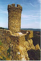
East Peak, 976 feet (297 m), is a prominent basalt traprock mountain in the Hanging Hills of Meriden, Connecticut. Rugged and scenic, the peak rises steeply above the city of Meriden 600 feet (183 m) below and is characterized by its vertical cliffs and sweeping views of southern Connecticut and Long Island Sound. A small stone observation tower known as Castle Craig stands on the summit.
East Peak is located within the 1,800-acre (7.3 km) Hubbard Park. The 51-mile (82 km) Metacomet Trail crosses East Peak, and a seasonal auto road climbs to a small parking lot at Castle Craig. Activities enjoyed on the peak include Hiking, bicycling, and in the winter, cross-country skiing on the road. Rock climbing is only permitted for Ragged Mountain Foundation members who have obtained a permit from Meriden's parks and recreation department.
See also
References
- "Meriden Cliffs — Ragged Mtn Foundation". Retrieved July 18, 2022.
External links
- "Hubbard Park Hiking Trails" (PDF). Meriden Land Trust. Archived from the original (PDF) on April 12, 2012. Retrieved March 5, 2012.
- Connecticut Walk Book 17th ed. Connecticut Forest and Park Association.
- The City of Meriden


