| Revision as of 12:48, 16 March 2008 editVolkovBot (talk | contribs)447,718 editsm robot Adding: eo:Choluteca← Previous edit | Revision as of 21:48, 27 July 2008 edit undoFvasconcellos (talk | contribs)Autopatrolled, Administrators30,939 editsm moved Choluteca (department) to Choluteca Department: consistency with articles on similar subdivisionsNext edit → |
| (No difference) | |
Revision as of 21:48, 27 July 2008

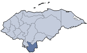
Choluteca is one of the 18 departments (departamentos) into which the Central American nation of Honduras is divided. It is the southernmost department of Honduras, bordering the Gulf of Fonseca to the west and the Republic of Nicaragua to the east and south.
The departmental capital is city of Choluteca. There is also a river named Choluteca that runs through the department.
The department covers a total surface area of 4,211 km² and, in 2005, had an estimated population of 420,350 people.
Choluteca department was formed in 1825 as one of the original departments of post-colonial Honduras. It took its current form in 1893 when Valle department was formed out of the westernmost portion of the department.
Municipalities
- Apacilagua
- Choluteca
- Concepción de María
- Duyure
- El Corpus
- El Triunfo
- Marcovia
- Morolica
- Namasigue
- Orocuina
- Pespire
- San Antonio de Flores
- San Isidro
- San José
- San Marcos de Colón
- Santa Ana de Yusguare
This Honduras location article is a stub. You can help Misplaced Pages by expanding it. |
13°19′N 87°13′W / 13.317°N 87.217°W / 13.317; -87.217
Categories: