| Revision as of 14:32, 30 June 2009 editSupreme Deliciousness (talk | contribs)Extended confirmed users, Pending changes reviewers, Rollbackers22,598 edits Undid revision 299024610 by Fipplet (talk) Check the Golan page, Golan is controlled by Israel not a part of it.← Previous edit | Revision as of 14:44, 30 June 2009 edit undoFipplet (talk | contribs)2,782 edits Undid revision 299512301 by Supreme Deliciousness (talk)Next edit → | ||
| Line 2: | Line 2: | ||
| The '''Anti-Lebanon mountains''', is the Western name for the '''Eastern Lebanon Mountain Range''' ({{lang-ar|'''جبال لبنان الشرقية'''}}),which are a northeast-trending ] between ] and ]. Its Western name (Anti-Lebanon) comes from the Greek word for ‘opposite’. The majority of the mountain range lies in ]. The border between ] and ] is largely defined along the crest of the range. At its southern end it is also within ]. The range lies east of and parallel (opposite) to the ] range. To the west lies the ] in the north and the ] valley in the south. These valleys separate it from the Lebanon range in central Lebanon. To the east, in Syria, lies the ] which contains the city of ]. | The '''Anti-Lebanon mountains''', is the Western name for the '''Eastern Lebanon Mountain Range''' ({{lang-ar|'''جبال لبنان الشرقية'''}}),which are a northeast-trending ] between ] and ]. Its Western name (Anti-Lebanon) comes from the Greek word for ‘opposite’. The majority of the mountain range lies in ]. The border between ] and ] is largely defined along the crest of the range. At its southern end it is also within ]. The range lies east of and parallel (opposite) to the ] range. To the west lies the ] in the north and the ] valley in the south. These valleys separate it from the Lebanon range in central Lebanon. To the east, in Syria, lies the ] which contains the city of ]. | ||
| The Anti-Lebanon range is approximately 150 km in length. To the north, it extends to almost the latitude of the Syrian city of ] before dying out. To the south, the range coalesces with the Golan Heights plateau but includes the highest peaks of ] (Jabalu sh-Shaykh, in Arabic جبل الشيخ), at 2,814 metres and ] at 2,669 metres. These peaks are snow-covered for much of the year and are located on the ]i |
The Anti-Lebanon range is approximately 150 km in length. To the north, it extends to almost the latitude of the Syrian city of ] before dying out. To the south, the range coalesces with the Golan Heights plateau but includes the highest peaks of ] (Jabalu sh-Shaykh, in Arabic جبل الشيخ), at 2,814 metres and ] at 2,669 metres. These peaks are snow-covered for much of the year and are located on the ]i-]-]n Border. | ||
| {{coord|34|00|N|36|30|E|region:SY_type:mountain|display=title}} | {{coord|34|00|N|36|30|E|region:SY_type:mountain|display=title}} | ||
| Line 10: | Line 10: | ||
| ] | ] | ||
| ] | ] | ||
| ] | |||
| {{Lebanon-geo-stub}} | {{Lebanon-geo-stub}} | ||
Revision as of 14:44, 30 June 2009

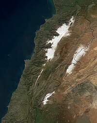
The Anti-Lebanon mountains, is the Western name for the Eastern Lebanon Mountain Range (Template:Lang-ar),which are a northeast-trending mountain range between Syria and Lebanon. Its Western name (Anti-Lebanon) comes from the Greek word for ‘opposite’. The majority of the mountain range lies in Syria. The border between Syria and Lebanon is largely defined along the crest of the range. At its southern end it is also within Israel. The range lies east of and parallel (opposite) to the Mount Lebanon range. To the west lies the Beqaa Valley in the north and the Hasbani River valley in the south. These valleys separate it from the Lebanon range in central Lebanon. To the east, in Syria, lies the Eastern Plateau which contains the city of Damascus.
The Anti-Lebanon range is approximately 150 km in length. To the north, it extends to almost the latitude of the Syrian city of Homs before dying out. To the south, the range coalesces with the Golan Heights plateau but includes the highest peaks of Mount Hermon (Jabalu sh-Shaykh, in Arabic جبل الشيخ), at 2,814 metres and Ta'a Musa at 2,669 metres. These peaks are snow-covered for much of the year and are located on the Israeli-Lebanese-Syrian Border.
34°00′N 36°30′E / 34.000°N 36.500°E / 34.000; 36.500
This Lebanon location article is a stub. You can help Misplaced Pages by expanding it. |
This Syria location article is a stub. You can help Misplaced Pages by expanding it. |