| Revision as of 16:45, 27 January 2021 editClueBot NG (talk | contribs)Bots, Pending changes reviewers, Rollbackers6,439,426 editsm Reverting possible vandalism by 95.168.118.15 to older version. Report False Positive? Thanks, ClueBot NG. (3880065) (Bot)Tags: Rollback Reverted← Previous edit | Latest revision as of 22:57, 2 November 2024 edit undoMonkbot (talk | contribs)Bots3,695,952 editsm Task 20: replace {lang-??} templates with {langx|??} ‹See Tfd› (Replaced 1);Tag: AWB | ||
| (31 intermediate revisions by 22 users not shown) | |||
| Line 1: | Line 1: | ||
| {{for|the village in Slovenia|Bilje, Miren – Kostanjevica}} | |||
| {{Infobox settlement | {{Infobox settlement | ||
| | name |
| name = Bilje | ||
| ⚫ | | official_name = Bilje Municipality<br>''Općina Bilje'' | ||
| | native_name |
| native_name = {{native name|hu|Bellye}}<ref name="Prijedlog izvještaja">{{cite web|url=https://www.coe.int/t/dg4/education/minlang/Report/PeriodicalReports/CroatiaPR5_hr.pdf | title=Peto izvješće Republike Hrvatske o primjeni Europske povelje o regionalnim ili manjinskim jezicima | date=October 2013 | author=Government of Croatia | publisher=] | page=34 | language=hr | format=PDF | access-date=30 November 2016}}</ref> | ||
| ⚫ | | pushpin_label = Bilje | ||
| ⚫ | | settlement_type = ] | ||
| ⚫ | | official_name = Bilje Municipality<br>''Općina Bilje'' | ||
| | image_skyline = Bilje-Bellye-Биље.jpg | |||
| ⚫ | | settlement_type = ] | ||
| | image_flag = The Flag of the Bilje-Bellye Municipality.gif | |||
| ⚫ | | subdivision_type = ] | ||
| | flag_size = 120px | |||
| ⚫ | | subdivision_name = {{flag|Croatia}} | ||
| | image_shield = The Coat of Arms of the Bilje Municipality.gif | |||
| ⚫ | | subdivision_type1 |
||
| | shield_size = 90px | |||
| ⚫ | | subdivision_name1 |
||
| | |
| pushpin_map = Croatia Osijek-Baranja County#Croatia#Europe | ||
| ⚫ | | pushpin_label = Bilje | ||
| ⚫ | | subdivision_name2 = ] ] | ||
| ⚫ | | coordinates = {{coord|45|36|25|N|18|44|38|E|region:HR-14|display=inline,title}} | ||
| | image_skyline = | |||
| ⚫ | | subdivision_type = ] | ||
| | pushpin_map = Croatia Osijek-Baranja County#Croatia | |||
| ⚫ | | subdivision_name = {{flag|Croatia}} | ||
| ⚫ | | coordinates = {{coord|45|36|25|N|18|44|38|E|region:HR-14|display=inline,title}} | ||
| ⚫ | | subdivision_type1 = ] | ||
| ⚫ | | leader_title = Mayor of Municipality | ||
| ⚫ | | subdivision_name1 = ] (]) | ||
| ⚫ | | leader_name = Željko Cickaj | ||
| | subdivision_type2 = ] | |||
| | area_footnotes = <ref name="HGK-Područja od posebne državne skrbi">{{cite web|url=https://www.hgk.hr/documents/opcineppdsdocx578c8f61e2fed.pdf |publisher=] |title=Općine na područjima posebne državne skrbi Republike Hrvatske |access-date=15 April 2020 }}</ref> | |||
| ⚫ | | subdivision_name2 = ] ] | ||
| ⚫ | | area_total_km2 |
||
| ⚫ | | leader_title = Mayor of Municipality | ||
| ⚫ | | elevation_m = 87 | ||
| ⚫ | | leader_name = Željko Cickaj | ||
| ⚫ | | population_total = |
||
| | area_footnotes = <ref>{{Cite Q|Q119585703|mode=cs1}}</ref> | |||
| ⚫ | | timezone = ] | ||
| ⚫ | | area_total_km2 = 259.5 | ||
| ⚫ | | utc_offset = +1 | ||
| | area_urban_km2 = 17.3 | |||
| ⚫ | |website= {{ |
||
| ⚫ | | elevation_m = 87 | ||
| | population_footnotes = <ref name="Census 2021">{{Croatian Census 2021|S}}</ref> | |||
| | population_as_of = 2021 | |||
| ⚫ | | population_total = 4772 | ||
| | population_density_km2 = auto | |||
| | population_urban = 3163 | |||
| | population_density_urban_km2 = auto | |||
| ⚫ | | timezone = ] | ||
| ⚫ | | utc_offset = +1 | ||
| ⚫ | | website = {{URL|bilje.hr}} | ||
| }} | }} | ||
| ] | ] | ||
| '''Bilje''' ({{ |
'''Bilje''' ({{langx|hu|Bellye}}) is a municipality in the ] of ], in north-eastern ]. It is 5 km northeast of ], on the edge of the ] ]. ] (1663-1736) constructed a hunting lodge here, ], which later became property of the Teschen branch of the ] family. | ||
| ==Name== | ==Name== | ||
| Its name derived from the Slavic word "bilje" ("herb" in English). In ] the village is known as ''Belje'', in ] as ''Bellye'',<ref name="Minority names">{{cite web|url=http://www.nipp.hr/UserDocsImages/Registar%20geografska%20imena%20nacionalnih%20manjina%20RH.pdf|title=Registar Geografskih Imena Nacionalnih Manjina Republike Hrvatske|format=PDF|access-date=2013-03-08|url-status=dead|archive-url=https://web.archive.org/web/20131029211333/http://www.nipp.hr/UserDocsImages/Registar%20geografska%20imena%20nacionalnih%20manjina%20RH.pdf|archive-date=2013-10-29}}</ref> and in ] as Биље. | Its name derived from the Slavic word "bilje" ("herb" in English). In ] the village is known as ''Belje'', in ] as ''Bellye'',<ref name="Minority names">{{cite web|url=http://www.nipp.hr/UserDocsImages/Registar%20geografska%20imena%20nacionalnih%20manjina%20RH.pdf|title=Registar Geografskih Imena Nacionalnih Manjina Republike Hrvatske|format=PDF|access-date=2013-03-08|url-status=dead|archive-url=https://web.archive.org/web/20131029211333/http://www.nipp.hr/UserDocsImages/Registar%20geografska%20imena%20nacionalnih%20manjina%20RH.pdf|archive-date=2013-10-29}}</ref> and in ] as Биље. The area occupied by the ] of Bilje is 260.15 km². <ref>{{Cite web |title=Page |url=https://bilje.hr/ |access-date=2023-04-10 |website=bilje.hr |language=hr}}</ref> | ||
| ==Geography== | ==Geography== | ||
| Line 49: | Line 57: | ||
| ==Demographics== | ==Demographics== | ||
| At the 2011 census, there were 5,642 inhabitants in the municipality,<ref name="Pop 2011"/> including:<ref>{{Croatian Census 2011|E|14}}</ref> | |||
| *62.87% ] | *62.87% ] | ||
| *29.62% ] | *29.62% ] | ||
| Line 55: | Line 63: | ||
| *1.05% ] | *1.05% ] | ||
| *0.71% ] | *0.71% ] | ||
| ==Politics== | |||
| ===Minority councils=== | |||
| Directly elected minority councils and representatives are tasked with consulting tasks for the local or regional authorities in which they are advocating for minority rights and interests, integration into public life and participation in the management of local affairs.<ref name="T-Portal">{{Cite web |url=https://www.tportal.hr/vijesti/clanak/manjinski-izbori-prve-nedjelje-u-svibnju-krecu-i-edukacije-20230313 |title=Manjinski izbori prve nedjelje u svibnju, kreću i edukacije |date= 13 March 2023 |author= |publisher=] |access-date=2 May 2023}}</ref> At the ] ] and ] each fulfilled legal requirements to elect 10 members municipal minority councils of the Bilje Municipality.<ref name="OBŽ-Manjine-2023">{{cite web | url=https://www.izbori.hr/site/UserDocsImages/2023/Manjinski%20izbori%202023/Rezultati/Z14_OSJECKO_BARANJSKA_ZUPANIJA.pdf | title=Informacija o konačnim rezultatima izbora članova vijeća i izbora predstavnika nacionalnih manjina 2023. XIV. OSJEČKO-BARANJSKA ŽUPANIJA | date=2023 | author= | publisher=Državno izborno povjerenstvo Republike Hrvatske | page=19 | language=hr | format=PDF | access-date=3 June 2023 | archive-date=3 June 2023 | archive-url=https://web.archive.org/web/20230603101819/https://www.izbori.hr/site/UserDocsImages/2023/Manjinski%20izbori%202023/Rezultati/Z14_OSJECKO_BARANJSKA_ZUPANIJA.pdf | url-status=dead }}</ref> | |||
| ==History== | ==History== | ||
| Line 70: | Line 82: | ||
| ] | ] | ||
| ] | ] | ||
| ] | |||
Latest revision as of 22:57, 2 November 2024
Municipality in Baranya, Croatia| Bilje Bellye (Hungarian) | |
|---|---|
| Municipality | |
| Bilje Municipality Općina Bilje | |
 | |
 Flag Flag Coat of arms Coat of arms | |
   | |
| Coordinates: 45°36′25″N 18°44′38″E / 45.60694°N 18.74389°E / 45.60694; 18.74389 | |
| Country | |
| Region | Baranya (Podunavlje) |
| County | |
| Government | |
| • Mayor of Municipality | Željko Cickaj |
| Area | |
| • Municipality | 259.5 km (100.2 sq mi) |
| • Urban | 17.3 km (6.7 sq mi) |
| Elevation | 87 m (285 ft) |
| Population | |
| • Municipality | 4,772 |
| • Density | 18/km (48/sq mi) |
| • Urban | 3,163 |
| • Urban density | 180/km (470/sq mi) |
| Time zone | UTC+1 (Central European Time) |
| Website | bilje |

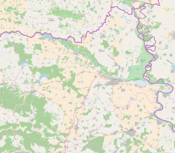
Bilje (Hungarian: Bellye) is a municipality in the Baranja region of Osijek-Baranja County, in north-eastern Croatia. It is 5 km northeast of Osijek, on the edge of the Kopački Rit nature park. Prince Eugene of Savoy (1663-1736) constructed a hunting lodge here, Bilje Castle, which later became property of the Teschen branch of the Habsburg family.
Name
Its name derived from the Slavic word "bilje" ("herb" in English). In German the village is known as Belje, in Hungarian as Bellye, and in Serbian Cyrillic as Биље. The area occupied by the municipality of Bilje is 260.15 km².
Geography
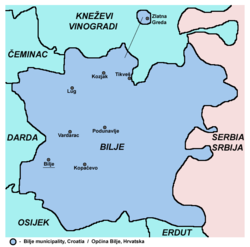
The municipality of Bilje include following settlements and population (2011 census):
- Bilje - 3,613
- Kopačevo - 559
- Kozjak - 69
- Lug - 764
- Podunavlje - 1
- Tikveš - 10
- Vardarac - 630
- Zlatna Greda - 5
Demographics
At the 2011 census, there were 5,642 inhabitants in the municipality, including:
- 62.87% Croats
- 29.62% Hungarians
- 3.83% Serbs
- 1.05% Germans
- 0.71% Romani
Politics
Minority councils
Directly elected minority councils and representatives are tasked with consulting tasks for the local or regional authorities in which they are advocating for minority rights and interests, integration into public life and participation in the management of local affairs. At the 2023 Croatian national minorities councils and representatives elections Hungarians and Serbs of Croatia each fulfilled legal requirements to elect 10 members municipal minority councils of the Bilje Municipality.
History
In the late 19th and early 20th century, Bilje was part of the Baranya County of the Kingdom of Hungary.
References
- Government of Croatia (October 2013). "Peto izvješće Republike Hrvatske o primjeni Europske povelje o regionalnim ili manjinskim jezicima" (PDF) (in Croatian). Council of Europe. p. 34. Retrieved 30 November 2016.
- Register of spatial units of the State Geodetic Administration of the Republic of Croatia. Wikidata Q119585703.
- "Population by Age and Sex, by Settlements" (xlsx). Census of Population, Households and Dwellings in 2021. Zagreb: Croatian Bureau of Statistics. 2022.
- "Registar Geografskih Imena Nacionalnih Manjina Republike Hrvatske" (PDF). Archived from the original (PDF) on 2013-10-29. Retrieved 2013-03-08.
- "Page". bilje.hr (in Croatian). Retrieved 2023-04-10.
- ^ "Population by Age and Sex, by Settlements, 2011 Census: Bilje". Census of Population, Households and Dwellings 2011. Zagreb: Croatian Bureau of Statistics. December 2012.
- "Population by Ethnicity, by Towns/Municipalities, 2011 Census: County of Osijek-Baranja". Census of Population, Households and Dwellings 2011. Zagreb: Croatian Bureau of Statistics. December 2012.
- "Manjinski izbori prve nedjelje u svibnju, kreću i edukacije". T-portal. 13 March 2023. Retrieved 2 May 2023.
- "Informacija o konačnim rezultatima izbora članova vijeća i izbora predstavnika nacionalnih manjina 2023. XIV. OSJEČKO-BARANJSKA ŽUPANIJA" (PDF) (in Croatian). Državno izborno povjerenstvo Republike Hrvatske. 2023. p. 19. Archived from the original (PDF) on 3 June 2023. Retrieved 3 June 2023.
| Subdivisions of Osijek-Baranja County | ||
|---|---|---|
| Cities and towns |  | |
| Municipalities |
| |