| Revision as of 13:14, 5 October 2022 editTetraxile (talk | contribs)86 editsm →Overview: changed number grouping separator← Previous edit |
Latest revision as of 03:14, 4 January 2025 edit undoHtialilwW (talk | contribs)334 editsNo edit summaryTags: Mobile edit Mobile web edit |
| (9 intermediate revisions by 8 users not shown) |
| Line 1: |
Line 1: |
|
{{Short description|Administrative divisions of Iceland}} |
|
{{Short description|Administrative divisions of Iceland}} |
|
{{Politics of Iceland}} |
|
{{Politics of Iceland}} |
|
The '''regions of ]''' are eight areas of Iceland that roughly follow the arrangement of ] as they were between 1959 and 2003. These regions are not incorporated ] but rather recognized groupings of municipalities. Iceland only has two levels of administration, the national government and 69 ]. The municipalities have organized themselves into eight regional associations<ref>{{cite web |title=Landshlutasamtök |url=https://www.samband.is/sveitarfelogin/#tab4 |publisher=Icelandic Association of Local Authorities |access-date=10 June 2021}}</ref> and those boundaries are also recognized by ] to report statistics.<ref>{{cite web |title=Iceland in figures 2018 |url=https://issuu.com/hagstofa/docs/iceland_in_figures_2018 |publisher=Statistics Iceland |access-date=10 June 2021}}</ref> Since 2014, ] and commissioner ('']'') districts have followed the eight region model with the exception that ] form a special district and are not part of the South region. The divisions of Iceland for the purposes of health care and district courts diverge more from the commonly used eight region model. |
|
The '''regions of ]''' are eight areas of Iceland that roughly follow the arrangement of ] as they were between 1959 and 2003. These regions are not incorporated ] but rather recognized groupings of municipalities. Iceland only has two levels of administration, the national government and 62 ]. The municipalities have organized themselves into eight regional associations<ref>{{cite web |title=Landshlutasamtök |url=https://www.samband.is/sveitarfelogin/#tab4 |publisher=Icelandic Association of Local Authorities |access-date=10 June 2021}}</ref> and those boundaries are also recognized by ] to report statistics.<ref>{{cite web |title=Iceland in figures 2018 |date=12 June 2018 |url=https://issuu.com/hagstofa/docs/iceland_in_figures_2018 |publisher=Statistics Iceland |access-date=10 June 2021}}</ref> Since 2014, ] and commissioner ('']'') districts have followed the eight region model with the exception that ] form a special district and are not part of the South region. The divisions of Iceland for the purposes of health care and district courts diverge more from the commonly used eight region model. |
|
|
|
|
|
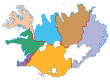
The ] system also roughly corresponds with the regions with the first digit of the three digit codes usually being the same as on the map below. |
|
The ] system also roughly corresponds with the regions with the first digit of the three digit codes usually being the same as on the map below. |
|
|
|
|
|
==Overview== |
|
==Overview== |
|
⚫ |
] |
|
{|class="sortable wikitable" style="text-align: right;" |
|
{| class="wikitable sortable" style="text-align: right;” |
| ⚫ |
| colspan="9" |] |
|
|
|- |
|
|- |
|
!No. |
|
!No. |
| Line 13: |
Line 13: |
|
!Native name |
|
!Native name |
|
!Population |
|
!Population |
|
(2022)<ref></ref> |
|
(2024)<ref></ref> |
|
!Area(km²) |
|
!Area (km<sup>2</sup>) |
|
!style="width: 8.5em;" | Population density (per km²) |
|
!style="width: 8.5em;" | Population density (per km<sup>2</sup>) |
|
!] |
|
!] |
|
!style="width: 7.0em;" | Number of municipalities |
|
!style="width: 7.0em;" | Number of municipalities |
| Line 23: |
Line 23: |
|
|style="text-align: left;"|] |
|
|style="text-align: left;"|] |
|
|style="text-align: left;"|Höfuðborgarsvæðið |
|
|style="text-align: left;"|Höfuðborgarsvæðið |
|
|240,882 |
|
|244,177 |
|
|1,046 |
|
|1,046 |
|
|230.29 |
|
|233.44 |
|
|IS-1 |
|
|IS-1 |
|
|7 |
|
|7 |
| Line 33: |
Line 33: |
|
|style="text-align: left;"|] |
|
|style="text-align: left;"|] |
|
|style="text-align: left;"|Suðurnes |
|
|style="text-align: left;"|Suðurnes |
|
|29,108 |
|
|30,933 |
|
|813 |
|
|813 |
|
|35.80 |
|
|38.05 |
|
|IS-2 |
|
|IS-2 |
|
|4 |
|
|4 |
| Line 43: |
Line 43: |
|
|style="text-align: left;"|] |
|
|style="text-align: left;"|] |
|
|style="text-align: left;"|Vesturland |
|
|style="text-align: left;"|Vesturland |
|
|17,019 |
|
|17,419 |
|
|9,527 |
|
|9,527 |
|
|1.79 |
|
|1.83 |
|
|IS-3 |
|
|IS-3 |
|
|10 |
|
|9 |
|
|style="text-align: left;"|] |
|
|style="text-align: left;"|] |
|
|- |
|
|- |
| Line 53: |
Line 53: |
|
|style="text-align: left;"|] |
|
|style="text-align: left;"|] |
|
|style="text-align: left;"|Vestfirðir |
|
|style="text-align: left;"|Vestfirðir |
|
|7,205 |
|
|7,168 |
|
|8,842 |
|
|8,842 |
|
|0.81 |
|
|0.81 |
| Line 63: |
Line 63: |
|
|style="text-align: left;"|] |
|
|style="text-align: left;"|] |
|
|style="text-align: left;"|Norðurland vestra |
|
|style="text-align: left;"|Norðurland vestra |
|
|7,405 |
|
|7,294 |
|
|13,108 |
|
|13,108 |
|
|0.56 |
|
|0.56 |
|
|IS-5 |
|
|IS-5 |
|
|5 |
|
|4 |
|
|style="text-align: left;"|] |
|
|style="text-align: left;"|] |
|
|- |
|
|- |
| Line 73: |
Line 73: |
|
|style="text-align: left;"|] |
|
|style="text-align: left;"|] |
|
|style="text-align: left;"|Norðurland eystra |
|
|style="text-align: left;"|Norðurland eystra |
|
|31,161 |
|
|31,574 |
|
|22,677 |
|
|22,677 |
|
|1.37 |
|
|1.39 |
|
|IS-6 |
|
|IS-6 |
|
|11 |
|
|11 |
| Line 83: |
Line 83: |
|
|style="text-align: left;"|] |
|
|style="text-align: left;"|] |
|
|style="text-align: left;"|Austurland |
|
|style="text-align: left;"|Austurland |
|
|11,031 |
|
|11,085 |
|
|15,706 |
|
|15,706 |
|
|0.70 |
|
|0.71 |
|
|IS-7 |
|
|IS-7 |
|
|4 |
|
|4 |
| Line 93: |
Line 93: |
|
|style="text-align: left;"|] |
|
|style="text-align: left;"|] |
|
|style="text-align: left;"|Suðurland |
|
|style="text-align: left;"|Suðurland |
|
|32,437 |
|
|34,076 |
|
|30,983 |
|
|30,983 |
|
|1.05 |
|
|1.10 |
|
|IS-8 |
|
|IS-8 |
|
|15 |
|
|15 |
| Line 103: |
Line 103: |
|
!style="text-align: left;" |Iceland |
|
!style="text-align: left;" |Iceland |
|
!style="text-align: left;" |Ísland |
|
!style="text-align: left;" |Ísland |
|
!style="text-align: right;"|376,248 |
|
!style="text-align: right;"|383,726 |
|
!style="text-align: right;"|102,702 |
|
!style="text-align: right;"|102,702 |
|
!style="text-align: right;"|3.66 |
|
!style="text-align: right;"|3.74 |
|
!style="text-align: right;"|IS |
|
!style="text-align: right;"|IS |
|
!style="text-align: right;"|64 |
|
!style="text-align: right;"|62 |
|
!style="text-align: right;"|Reykjavík |
|
!style="text-align: right;"|Reykjavík |
|
|} |
|
|} |
Until 1957, the parliamentary constituencies used in Iceland had been based on its counties and market towns. The reform of constituency borders in 1957 would group these counties and towns together into eight larger areas that form the basis for the modern regional division of Iceland. The differences between the 1957 boundaries and the modern ones are:


