| Revision as of 03:53, 18 November 2007 editKevin Steinhardt (talk | contribs)3,741 edits Removed custom 's-rail-start' template.← Previous edit | Latest revision as of 12:39, 7 October 2024 edit undoAaroncrudge (talk | contribs)Extended confirmed users5,152 edits →Connections: Added referencesTags: Mobile edit Mobile web edit | ||
| (53 intermediate revisions by 43 users not shown) | |||
| Line 1: | Line 1: | ||
| {{Short description|Tramlink tram stop in London, England}}{{Use dmy dates|date=February 2018}} | |||
| {{London Tram stations | |||
| {{Use British English|date=February 2018}} | |||
| ⚫ | |||
| {{Infobox station | |||
| | image = Ikea_Ampere_Way_Sign.jpg | |||
| ⚫ | | name = Ampere Way | ||
| | zone = ] | |||
| | symbol_location = london | symbol = tram | |||
| | manager = ] | |||
| | image = Ampere_Way_tramstop_look east.JPG | |||
| | locale = ] | |||
| | caption = | |||
| ⚫ | |||
| | operator = ] | |||
| ⚫ | | address = ], ] | ||
| ⚫ | |||
| | country = United Kingdom | |||
| ⚫ | | platforms = 2 | ||
| | accessible = yes | |||
| | zone = ] 3, 4, 5 and 6 | |||
| | opened = {{Start date and age|df=y|2000|5|30}} | |||
| | mpassengers = {{Rail pass box|passengers=0.715 million total boardings and alightings<ref name="infobox_stats_ref_ct1">{{Citation CT bat 0910}}</ref>|pass_year=2009–10}} | |||
| {{Rail pass box|passengers=0.803 million total boardings and alightings<ref name="infobox_stats_ref_ct2">{{Citation CT bat 1011}}</ref>|pass_year=2010–11}} | |||
| }} | }} | ||
| ⚫ | '''Ampere Way''' is a ] stop in the ], serving the ] commercial area. ] trams serve the stop, which is located opposite ] Croydon. | ||
| {{stack| | |||
| ] | |||
| ⚫ | ] | ||
| }} | |||
| When the stop opened, it was named "Ampere Way" in reference to the nearby former Croydon Power Station. The two chimneys from the old power station still exist in the grounds of the ] store. | |||
| ⚫ | The station was renamed IKEA Ampere Way under a sponsorship deal<ref></ref> on 18 October 2006, in order to promote the stop's location near ]'s Croydon store.<ref></ref> By March 2008, the station had reverted to its former name. | ||
| ⚫ | ] | ||
| The tram stop is served by tram services between Elmers End/Beckenham Junction and Wimbledon. | |||
| ⚫ | ''' |
||
| ==Services== | |||
| ⚫ | |||
| The typical off-peak service in trams per hour from Ampere Way is:<ref>{{cite web|url=https://tfl.gov.uk/tram/timetable/tram/|title=Tram Timetables|work=]|access-date=7 October 2024}}</ref><ref>{{cite web|url=https://tfl.gov.uk/cdn/static/cms/documents/tram-service-map.pdf|title=London Trams Map|work=]|access-date=7 October 2024}}</ref> | |||
| <br /> | |||
| * 6 tph in each direction between {{stn|Beckenham Junction}} and {{stn|Wimbledon}} | |||
| {{s-rail-start}} | |||
| * 6 tph in each direction between {{stn|Elmers End}} and Wimbledon | |||
| ⚫ | {{ |
||
| ⚫ | |||
| {{end}} | |||
| Services are operated using ] and ] ]. | |||
| ⚫ | == References == | ||
| {{Adjacent stations|noclear=y | |||
| |system1=Tramlink | |||
| |line1=Beckenham Junction|left1=Therapia Lane|right1=Waddon Marsh | |||
| ⚫ | |line2=Elmers End|left2=Therapia Lane|right2=Waddon Marsh | ||
| }} | |||
| ==Connections== | |||
| ] route ] serves the tram stop.<ref>{{cite web|url=https://tfl.gov.uk/bus/stop/490002004E/ampere-way-tram-stop-valley-park/|title=Buses from Ampere Way tram stop|work=]|access-date=7 October 2024}}</ref> | |||
| Free interchange for journeys made within an hour is available between trams and buses as part of ]'s Hopper Fare.<ref>{{cite web|url=https://tfl.gov.uk/fares/find-fares/bus-and-tram-fares|title=Bus and Tram Fares|work=]|access-date=7 October 2024}}</ref> | |||
| ⚫ | == References == | ||
| {{reflist}} | {{reflist}} | ||
| ==External links== | |||
| ⚫ | {{UK-tram-stub}} | ||
| {{commons category|Ampere Way tram stop}} | |||
| * – Timetables and live departures at Transport for London | |||
| ⚫ | {{Tramlink}} | ||
| {{coord|51.3824|-0.1238|type:landmark_region:GB-CRY|display=title}} | |||
| ] | ] | ||
| ] | ] | ||
| ] | |||
| ⚫ | {{UK-tram-stub}} | ||
Latest revision as of 12:39, 7 October 2024
Tramlink tram stop in London, England
| Ampere Way | |
|---|---|
 | |
| General information | |
| Location | Croydon, London Borough of Croydon United Kingdom |
| Operated by | Tramlink |
| Platforms | 2 |
| Construction | |
| Accessible | Yes |
| Other information | |
| Fare zone | London fare zones 3, 4, 5 and 6 |
| History | |
| Opened | 30 May 2000; 24 years ago (2000-05-30) |
| Passengers | |
| 2009–10 | 0.715 million total boardings and alightings |
| 2010–11 | 0.803 million total boardings and alightings |
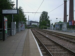
Ampere Way is a tram stop in the London Borough of Croydon, serving the Purley Way commercial area. Tramlink trams serve the stop, which is located opposite IKEA Croydon.


When the stop opened, it was named "Ampere Way" in reference to the nearby former Croydon Power Station. The two chimneys from the old power station still exist in the grounds of the IKEA store.
The station was renamed IKEA Ampere Way under a sponsorship deal on 18 October 2006, in order to promote the stop's location near IKEA's Croydon store. By March 2008, the station had reverted to its former name.
The tram stop is served by tram services between Elmers End/Beckenham Junction and Wimbledon.
Services
The typical off-peak service in trams per hour from Ampere Way is:
- 6 tph in each direction between Beckenham Junction and Wimbledon
- 6 tph in each direction between Elmers End and Wimbledon
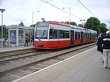
Services are operated using Bombardier CR4000 and Stadler Variobahn Trams.
| Preceding station | Following station | |||
|---|---|---|---|---|
| Therapia Lanetowards Wimbledon | Tramlink Wimbledon to Beckenham Junction |
Waddon Marshtowards Beckenham Junction | ||
| Tramlink Wimbledon to Elmers End |
Waddon Marshtowards Elmers End | |||
Connections
London Buses route S4 serves the tram stop.
Free interchange for journeys made within an hour is available between trams and buses as part of Transport for London's Hopper Fare.
References
- "Tram Stop Usage 2009-10 (FOI)" (XLS). Tramlink annual passenger performance 2009-2010. Transport for London. 18 August 2011. Retrieved 28 November 2012.
- "Tramlink numbers 2010-2011" (PDF). Tramlink annual passenger performance 2010-2011. Transport for London. 28 March 2012. Retrieved 28 November 2012.
- Croydon Tramlink – The Unofficial Site
- http://www.croydon-tramlink.co.uk
- "Tram Timetables". Transport for London. Retrieved 7 October 2024.
- "London Trams Map" (PDF). Transport for London. Retrieved 7 October 2024.
- "Buses from Ampere Way tram stop". Transport for London. Retrieved 7 October 2024.
- "Bus and Tram Fares". Transport for London. Retrieved 7 October 2024.
External links
- Ampere Way Tram Stop – Timetables and live departures at Transport for London
| Tramlink | |||||||||
|---|---|---|---|---|---|---|---|---|---|
| Tram stops |
| ||||||||
| Proposed developments |
| ||||||||
| Rolling stock | |||||||||
| Related topics | |||||||||
51°22′57″N 0°07′26″W / 51.3824°N 0.1238°W / 51.3824; -0.1238
This UK Tram-related article is a stub. You can help Misplaced Pages by expanding it. |