| Revision as of 10:07, 16 June 2008 editDr. Blofeld (talk | contribs)Autopatrolled, Extended confirmed users, Pending changes reviewers, Rollbackers, Template editors636,306 edits population is incorrect though, it isnt for the metro but for the prefecture← Previous edit | Latest revision as of 21:59, 4 November 2024 edit undoMonkbot (talk | contribs)Bots3,695,952 editsm Task 20: replace {lang-??} templates with {langx|??} ‹See Tfd› (Replaced 1);Tag: AWB | ||
| (34 intermediate revisions by 26 users not shown) | |||
| Line 1: | Line 1: | ||
| {{Infobox |
{{Infobox settlement | ||
| <!--See the Table at Infobox Settlement for all fields and descriptions of usage--> | <!--See the Table at Infobox Settlement for all fields and descriptions of usage--> | ||
| <!-- Basic info ----------------> |official_name = Am Dam | <!-- Basic info ----------------> |official_name = Am Dam | ||
| |other_name = | |other_name = | ||
| |native_name = {{lang|ar|أم دام}} | |||
| |native_name = <!-- for cities whose native name is not in English --> | |||
| |nickname = | |nickname = | ||
| |settlement_type = <!--For Town or Village (Leave blank for the default City)--> | |settlement_type = <!--For Town or Village (Leave blank for the default City)--> | ||
| Line 32: | Line 32: | ||
| |dot_y = | |dot_y = | ||
| |pushpin_map = Chad <!-- the name of a location map as per http://en.wikipedia.org/Template:Location_map --> | |pushpin_map = Chad <!-- the name of a location map as per http://en.wikipedia.org/Template:Location_map --> | ||
| |pushpin_mapsize= |
|pushpin_mapsize= | ||
| |pushpin_label_position =bottom | |pushpin_label_position =bottom | ||
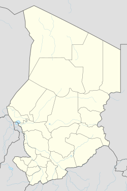
| |pushpin_map_caption = Location in Chad | |pushpin_map_caption = Location in Chad | ||
| Line 38: | Line 38: | ||
| |subdivision_type = Country | |subdivision_type = Country | ||
| |subdivision_name = {{flag|Chad}} | |subdivision_name = {{flag|Chad}} | ||
| |subdivision_type1 = ] | |subdivision_type1 = ] | ||
| |subdivision_name1 = ] | |subdivision_name1 = ] | ||
| |subdivision_type2 = ] | |subdivision_type2 = ] | ||
| |subdivision_name2 = ] | |subdivision_name2 = ] | ||
| Line 93: | Line 93: | ||
| |population_footnotes = | |population_footnotes = | ||
| |population_note = | |population_note = | ||
| |population_total = |
|population_total = | ||
| |population_density_km2 = | |population_density_km2 = | ||
| |population_density_sq_mi = | |population_density_sq_mi = | ||
| Line 113: | Line 113: | ||
| |timezone_DST = | |timezone_DST = | ||
| |utc_offset_DST = | |utc_offset_DST = | ||
| |coordinates = {{coord|12|45|44|N|20|28|13|E|region:TD|display=inline}} | |||
| |latd= 12 | |||
| |latm= 45 | |||
| |lats= 44 | |||
| |latNS=N | |||
| |longd= 20 | |||
| |longm= 28 | |||
| |longs= 13 | |||
| |longEW=E | |||
| |elevation_footnotes = | |elevation_footnotes = | ||
| <!--for references: use <ref> </ref> tags--> | <!--for references: use <ref> </ref> tags--> | ||
| Line 136: | Line 129: | ||
| |website = | |website = | ||
| |footnotes = }} | |footnotes = }} | ||
| '''Am Dam''' is the capital of ] ] in ] ], ], located at an important crossroads in the ] valley. It |
'''Am Dam''' ({{langx|ar|أم دام}}) is the capital of ] ] in ] ], ], located at an important crossroads in the ] valley. It is a small town about {{convert|120|km|mi|abbr=on}} northwest of Goz-Beida and {{convert|700|km|mi|abbr=on}} by road from the capital ].<ref> '']''</ref> Am Dam is also the name of the ] that the city is within. The population of the entire Am Dam Sub-Prefecture is 77,593.<ref></ref> | ||
| The town is served by ]. | |||
| ==History== | |||
| It was captured by rebels advancing on ] on June 15, 2008.<ref> '']''</ref> A ] near the town stopped an attempted rebel offensive in May 2009 and put the town under Chadian government control again, with more than 200 reported deaths.<ref>{{cite web |url=http://www.france24.com/en/20090511-chad-rebels-retreat-sudan-bases |title=France24 - Chad rebels retreat to Sudan bases |website=www.france24.com |url-status=dead |archive-url=https://web.archive.org/web/20100605230431/http://www.france24.com/en/20090511-chad-rebels-retreat-sudan-bases |archive-date=2010-06-05}} </ref> | |||
| ==References== | ==References== | ||
| {{Reflist}} | {{Reflist}} | ||
| {{ |
{{coord|12|45|44|N|20|28|13|E|display=title}} | ||
| ] | |||
| {{Chad-geo-stub}} | |||
| ] | ] | ||
Latest revision as of 21:59, 4 November 2024
Place in Sila, Chad| Am Dam أم دام | |
|---|---|
 | |
| Coordinates: 12°45′44″N 20°28′13″E / 12.76222°N 20.47028°E / 12.76222; 20.47028 | |
| Country | |
| Region | Sila |
| Department | Djourf Al Ahmar |
| Sub-Prefecture | Am Dam |
| Elevation | 1,453 ft (443 m) |
| Time zone | + 1 |
Am Dam (Arabic: أم دام) is the capital of Djourf Al Ahmar Department in Sila Region, Chad, located at an important crossroads in the Batha River valley. It is a small town about 120 km (75 mi) northwest of Goz-Beida and 700 km (430 mi) by road from the capital N'Djamena. Am Dam is also the name of the Sub-Prefecture that the city is within. The population of the entire Am Dam Sub-Prefecture is 77,593.
The town is served by Am Dam Airport.
History
It was captured by rebels advancing on N'Djamena on June 15, 2008. A battle near the town stopped an attempted rebel offensive in May 2009 and put the town under Chadian government control again, with more than 200 reported deaths.
References
- Chad rebels say occupy town closer to capital Reuters
- Statoids
- Advancing Chad rebels take town BBC News
- "France24 - Chad rebels retreat to Sudan bases". www.france24.com. Archived from the original on 2010-06-05.
12°45′44″N 20°28′13″E / 12.76222°N 20.47028°E / 12.76222; 20.47028
Categories: