| Revision as of 21:36, 9 February 2013 editMONGO (talk | contribs)Autopatrolled, Extended confirmed users, File movers, Pending changes reviewers, Rollbackers76,644 edits revise← Previous edit | Latest revision as of 14:58, 10 August 2024 edit undoEntranced98 (talk | contribs)Extended confirmed users, Pending changes reviewers, Rollbackers172,912 edits Importing Wikidata short description: "Glacier in Colorado, USA"Tag: Shortdesc helper | ||
| (18 intermediate revisions by 15 users not shown) | |||
| Line 1: | Line 1: | ||
| {{Short description|Glacier in Colorado, USA}} | |||
| {{Use mdy dates|date=February 2013}} | |||
| {{Infobox glacier | {{Infobox glacier | ||
| | name = Arapaho Glacier | | name = Arapaho Glacier | ||
| | photo = | | photo = Arapaho Glacier, photo X12.tif | ||
| | photo_caption = | | photo_caption = | ||
| | type = Mountain glacier | | type = Mountain glacier | ||
| | location = ], |
| location = ], United States | ||
| | map |
| map = USA Colorado | ||
| | map_caption = Location in Colorado | |||
| | region = US-CO | |||
| | label_position = right | | label_position = right | ||
| | map_size |
| map_size = 225 | ||
| | coordinates = {{coord|40|01|24|N|105|38|52|W|region:US-CO|format=dms|display=inline,title}} | |||
| | lat_d= 40 | lat_m= 01 | lat_s =24 |lat_NS =N | |||
| | coordinates_ref =<ref name=gnis>{{cite gnis|id=178461|name=Arapaho Glacier|accessdate=2012-08-18}}</ref> | |||
| | long_d=105 | long_m=38 | long_s=52 |long_EW=W | |||
| | |
| area = {{convert|39|acres|abbr=on}}<ref name=arapaho>{{cite web|title=Arapaho Glacier|url=http://nsidc.org/rocs/adopt-a-glacier/arapaho.html|publisher=National Snow and Ice Data Center|accessdate=2017-10-02}} (dead link 28 April 2018)</ref> | ||
| | area = {{convert|39|acres|abbr=on}}<ref name=arapaho>{{cite web|title=Arapaho Glacier|url=http://nsidc.org/rocs/adopt-a-glacier/arapaho.html|publisher=National Snow and Ice Data Center|accessdate=2012-08-18}}</ref> | |||
| | length = {{convert|.25|mi|abbr=on}} long and {{convert|.50|mi|abbr=on}} wide<ref name=arapaho/> | | length = {{convert|.25|mi|abbr=on}} long and {{convert|.50|mi|abbr=on}} wide<ref name=arapaho/> | ||
| | thickness = {{convert|15|ft|abbr=on}}<ref name=arapaho/> | | thickness = {{convert|15|ft|abbr=on}}<ref name=arapaho/> | ||
| Line 18: | Line 19: | ||
| | status = Retreating | | status = Retreating | ||
| }} | }} | ||
| '''Arapaho Glacier''' is an ] in a cirque immediately southeast of ], in ] in the U.S. state of ].<ref name=topo>{{Cite map|publisher=TopoQwest (United States Geological Survey Maps)|title=Monarch Lake, CO|url=http://www.topoquest.com/map.php?lat=40.02328&lon=-105.64780&datum=nad83&zoom=4|accessdate=2012-08-18}}</ref> The glacier is just east of the ]. Arapaho Glacier is the largest glacier in the state of Colorado and helps provide water for the city of ]. The glacier has a negative ] and lost 52% of its surface area during the 20th Century.<ref name=arapaho/> |
'''Arapaho Glacier''' is an ] in a cirque immediately southeast of ], in ] in the U.S. state of ].<ref name=topo>{{Cite map|publisher=TopoQwest (United States Geological Survey Maps)|title=Monarch Lake, CO|url=http://www.topoquest.com/map.php?lat=40.02328&lon=-105.64780&datum=nad83&zoom=4|accessdate=2012-08-18}}</ref> The glacier is just east of the ]. Arapaho Glacier is the largest glacier in the state of Colorado and helps provide water for the city of ]. The glacier has a negative ] and lost over 52% of its surface area during the 20th Century.<ref name=arapaho/> | ||
| ==See also== | ==See also== | ||
| *] | *] | ||
| ⚫ | ==External links== | ||
| ⚫ | * |
||
| ==References== | ==References== | ||
| {{ |
{{Reflist}} | ||
| ] | |||
| {{Commons category|Arapaho Glacier}} | {{Commons category|Arapaho Glacier}} | ||
| ⚫ | ==External links== | ||
| ⚫ | * | ||
| {{Glaciers of Colorado}} | {{Glaciers of Colorado}} | ||
| {{Authority control}} | |||
| ] | ] | ||
| ] | ] | ||
| {{Colorado-geo-stub}} | {{Colorado-geo-stub}} | ||
| {{US-glacier-stub}} | |||
Latest revision as of 14:58, 10 August 2024
Glacier in Colorado, USA
| Arapaho Glacier | |
|---|---|
 | |
 | |
| Type | Mountain glacier |
| Location | Boulder County, Colorado, United States |
| Coordinates | 40°01′24″N 105°38′52″W / 40.02333°N 105.64778°W / 40.02333; -105.64778 |
| Area | 39 acres (16 ha) |
| Length | .25 mi (0.40 km) long and .50 mi (0.80 km) wide |
| Thickness | 15 ft (4.6 m) |
| Terminus | Talus/proglacial lake |
| Status | Retreating |
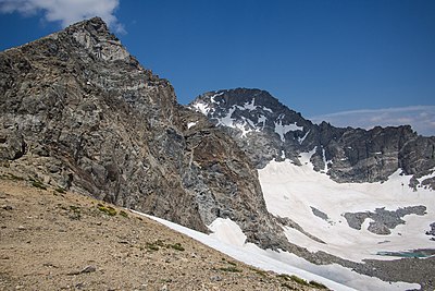
Arapaho Glacier is an alpine glacier in a cirque immediately southeast of North Arapaho Peak, in Roosevelt National Forest in the U.S. state of Colorado. The glacier is just east of the Continental Divide. Arapaho Glacier is the largest glacier in the state of Colorado and helps provide water for the city of Boulder, Colorado. The glacier has a negative glacier mass balance and lost over 52% of its surface area during the 20th Century.
See also
References
- "Arapaho Glacier". Geographic Names Information System. United States Geological Survey, United States Department of the Interior. Retrieved August 18, 2012.
- ^ "Arapaho Glacier". National Snow and Ice Data Center. Retrieved October 2, 2017. (dead link 28 April 2018)
- Monarch Lake, CO (Map). TopoQwest (United States Geological Survey Maps). Retrieved August 18, 2012.

External links
| Glaciers of Colorado | |
|---|---|
This Colorado state location article is a stub. You can help Misplaced Pages by expanding it. |
This article about a glacier in the United States is a stub. You can help Misplaced Pages by expanding it. |