| Revision as of 22:52, 16 March 2013 editYobot (talk | contribs)Bots4,733,870 editsm WP:CHECKWIKI error fixes using AWB (8976)← Previous edit |
Latest revision as of 05:18, 13 November 2024 edit undoHerniac (talk | contribs)Extended confirmed users1,879 edits Added short descriptionTags: Mobile edit Mobile app edit Android app edit App description add |
| (32 intermediate revisions by 20 users not shown) |
| Line 1: |
Line 1: |
|
|
{{Short description|Intermittent stream in Israel}} |
|
] |
|
|
|
{{Infobox protected area |
| ⚫ |
'''Nahal Betzet''' ({{lang-he|נחל בצת}}, {{lang-ar|''Wadi Karkara''}}) (lit. "Betzet stream") is a once-] and now ] in the ], ]. |
|
|
|
| name = Nahal Betzet Nature Reserve |
|
|
| alt_name = שמורת נחל בצת |
|
|
| iucn_category = |
|
|
| photo = KeshetCaveByAviv.JPG |
|
|
| photo_alt = |
|
|
| photo_caption= The arch known as Keshet Cave (Rainbow Cave), the remains of a large collapsed cave |
|
|
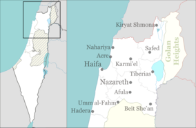
| map = Israel north haifa |
|
|
| location = ], ] |
|
|
| nearest_city = ] |
|
|
| coordinates = {{coord|33.0728|N|35.2144|E|source:wikidata-and-enwiki-cat-tree_region:IL|display=inline,title}} |
|
|
| area = {{convert|7650|dunam}} |
|
|
| established = 1972 |
|
|
| visitation_num = |
|
|
| visitation_year = |
|
|
| governing_body = ] |
|
|
}} |
|
⚫ |
'''{{lang|he-Latn|Nahal Betzet|italic=no}}''' ({{langx|he|נחל בצת}}, lit. "Betzet stream"; {{langx|ar|وادي كركرة}}, '''{{lang|ar-Latn|Wadi Karkara|italic=no}}'''), is a once-] and now ] in the ], ]. Most of it is part of the ] named for the stream. |
|
|
|
|
|
==Geography== |
|
==Geography== |
|
⚫ |
The stream crosses the border from ] into Israel between ] and ], and flows westward, emptying into the ] south of ]. The stream runs along a ] through ] and ], and is fed along its course by ]. Currently, ] (the national water company) pumps the water of the stream's springs, and has been accused of causing the stream to dry up.<ref>{{cite web|url=http://www.inature.info/%D7%A9%D7%9E%D7%95%D7%A8%D7%AA_%D7%A0%D7%97%D7%9C_%D7%91%D7%A6%D7%AA|title=Nahal Betzet Nature Reserve|language=Hebrew|accessdate=2010-10-05|publisher=iNature.info}}</ref> Many caves are formed on the banks of the stream, most notably the arch known as ] (Rainbow Cave). |
|
] |
|
| ⚫ |
The stream crosses the border from ] into Israel between ] and ], and flows westward, emptying into the ] south of ]. The stream runs along a ] through ] and ], and is fed along its course by ]. Currently, ] (the national water company) pumps the water of the stream's springs, and has been accused of causing the stream to dry up.<ref>{{cite web|url=http://www.inature.info/%D7%A9%D7%9E%D7%95%D7%A8%D7%AA_%D7%A0%D7%97%D7%9C_%D7%91%D7%A6%D7%AA|title=Nahal Betzet Nature Reserve|language=Hebrew|accessdate=2010-10-05|publisher=iNature.info}}</ref> Many caves are formed on the banks of the stream, most notably the Keshet Cave. |
|
|
|
|
|
|
==Nature reserve== |
|
==Nature reserve== |
|
Most of the stream is part of a nature reserve that bears its name.<ref>{{cite web|url=http://www.protectedplanet.net/sites/Nahal_Bezet_Nature_Reserve|title=Nahal Betzet Nature Reserve|publisher=ProtectedPlanet.com}}</ref> The reserve, declared in 1972 covers 7650-]<ref>{{cite web|title=List of National Parks and Nature Reserves|url=http://parks.org.il/sigalit/muchrazim.pdf|language=Hebrew|publisher=Israel Nature and Parks Authority|accessdate=2010-09-27}}</ref> and part of it reaches the Israel-Lebanese border. In 2009, 1225 dunams were added to the reserve. |
|
Most of the stream is part of a nature reserve that bears its name.<ref>{{cite web|url=http://www.protectedplanet.net/sites/Nahal_Bezet_Nature_Reserve|title=Nahal Betzet Nature Reserve|publisher=ProtectedPlanet.com}}</ref> The reserve, declared in 1972 covers 7650-]<ref>{{cite web|title=List of National Parks and Nature Reserves|url=http://parks.org.il/sigalit/muchrazim.pdf|language=Hebrew|publisher=Israel Nature and Parks Authority|accessdate=2010-09-27|url-status=dead|archive-url=https://web.archive.org/web/20091007095221/http://parks.org.il/sigalit/muchrazim.pdf|archive-date=2009-10-07}}</ref> and part of it reaches the Israel-Lebanese border. In 2009, 1225 dunams were added to the reserve. |
|
|
|
|
|
Flora in the area includes '']'', '']'', and '']''. |
|
Flora in the area includes '']'', '']'', and '']''. |
|
|
== Gallery == |
|
|
<gallery> |
|
|
File:PikiWiki Israel 87799 betzet river.jpg|Nahal Betzet |
|
|
File:Nahal Betzet (997009157460805171.jpg|Ruins at Nahal Betzet, identified as Khirbet Karkara, an archaeological site in Israel. |
|
|
File:PikiWiki Israel 87795 betzet river.jpg|Sarach Cave, a stalactite cave home to insect-eating bats, where visitors are advised not to disturb the bats. |
|
|
</gallery> |
|
|
|
|
|
==See also== |
|
|
*] |
|
|
|
|
|
==References== |
|
==References== |
|
{{reflist}} |
|
{{Reflist}} |
|
|
|
|
|
==External links== |
|
==External links== |
|
* |
|
* |
|
* |
|
* |
|
⚫ |
{{Streams of the Galilee}}{{Nature reserves of Israel}} |
|
|
|
|
|
{{Authority control}} |
|
{{coord missing|Israel}} |
|
|
|
{{commons category|Nahal Betzet}} |
|
|
|
| ⚫ |
{{Nature reserves of Israel}} |
|
|
|
|
|
|
{{DEFAULTSORT:Betzet, Nahal}} |
|
{{DEFAULTSORT:Betzet, Nahal}} |
|
] |
|
] |
|
] |
|
] |
|
|
] |
|
|
|
|
] |
|
|
] |
|
Most of the stream is part of a nature reserve that bears its name. The reserve, declared in 1972 covers 7650-dunam and part of it reaches the Israel-Lebanese border. In 2009, 1225 dunams were added to the reserve.
 The arch known as Keshet Cave (Rainbow Cave), the remains of a large collapsed cave
 Nahal Betzet
 Ruins at Nahal Betzet, identified as Khirbet Karkara, an archaeological site in Israel.
 Sarach Cave, a stalactite cave home to insect-eating bats, where visitors are advised not to disturb the bats.