| Revision as of 22:40, 21 February 2016 editWilliamJE (talk | contribs)Autopatrolled, Extended confirmed users, Pending changes reviewers132,561 edits →Notable natives← Previous edit | Latest revision as of 02:10, 7 October 2024 edit undoWikideas1 (talk | contribs)Extended confirmed users13,302 edits →Gallery: wikilink caption | ||
| (32 intermediate revisions by 20 users not shown) | |||
| Line 1: | Line 1: | ||
| {{Use mdy dates|date=July 2023}} | |||
| {{Infobox settlement | {{Infobox settlement | ||
| |name = Pickrelltown, Ohio | |name = Pickrelltown, Ohio | ||
| Line 22: | Line 23: | ||
| <!-- Location --> | <!-- Location --> | ||
| |subdivision_type = ] | |subdivision_type = ] | ||
| |subdivision_name = |
|subdivision_name = United States | ||
| |subdivision_type1 = ] | |subdivision_type1 = ] | ||
| |subdivision_name1 = ] | |subdivision_name1 = ] | ||
| |subdivision_type2 = ] | |subdivision_type2 = ] | ||
| |subdivision_name2 = ] | |subdivision_name2 = ] | ||
| |subdivision_type3 = ] | |||
| |subdivision_name3 = ] | |||
| |government_footnotes = | |government_footnotes = | ||
| Line 57: | Line 60: | ||
| |timezone_DST = EDT | |timezone_DST = EDT | ||
| |utc_offset_DST = -4 | |utc_offset_DST = -4 | ||
| |elevation_footnotes = | |elevation_footnotes = <ref name=gnis/> | ||
| |elevation_ft = | |elevation_ft = 1414 | ||
| |coordinates = {{coord|40|17|59|N|83|39|37|W|region:US_type:city|display=inline,title}} | |||
| |coordinates_display = inline,title | |||
| |coordinates_type = region:US_type:city | |||
| |latd = 40|latm = 17 |lats = 59|latNS = N | |||
| |longd = 83|longm = 39|longs = 37|longEW = W | |||
| <!-- Area/postal codes & others --> | <!-- Area/postal codes & others --> | ||
| Line 70: | Line 70: | ||
| |blank_name = ] | |blank_name = ] | ||
| |blank_info = | |blank_info = | ||
| |blank1_name = ] feature ID | |blank1_name = ] feature ID | ||
| |blank1_info = | |blank1_info = 1061538<ref name=gnis>{{GNIS|1061538}}</ref> | ||
| |website = | |website = | ||
| |footnotes = | |footnotes = | ||
| }} | }} | ||
| '''Pickrelltown''' is an ] in ].<ref name=gnis/> | |||
| '''Pickrelltown''' is an ] located at the intersection of two roads (County Roads 28 and 29) in northern ], ], ], ]. It has also been known as '''Frogtown''', and its current name has also been spelled '''Pickereltown''', '''Pickeretown''', and '''Pickreltown'''.<ref name=GNIS>{{gnis|1061538}}, ], 1979-07-12. Accessed 2008-01-10.</ref> The community consists of a few homes and a small church, plus a historic monument (a memorial to fallen soldiers from the community) placed in the middle of the intersection. The monument was destroyed in April 2000 by a car accident<ref>, ''Bellefontaine Examiner'', 2000-04-20. Accessed 2008-01-10.</ref> although it has been replaced. | |||
| The settlement is located at the intersection of County Roads 28 and 29 in northern ]. | |||
| Variant names of Pickrelltown include "Frogtown", "Pickereltown", "Pickeretown", and "Pickreltown".<ref name=gnis/> | |||
| ==History== | ==History== | ||
| A post office was established at Pickrelltown in 1851, and remained in operation until 1903.<ref>{{cite web | url=http://www.postalhistory.com/postoffices.asp?task=display&state=OH&county=Logan | title=Logan County | publisher=Jim Forte Postal History | accessdate=22 December 2015}}</ref> The |
A post office was established at Pickrelltown in 1851, and remained in operation until 1903.<ref>{{cite web | url=http://www.postalhistory.com/postoffices.asp?task=display&state=OH&county=Logan | title=Logan County | publisher=Jim Forte Postal History | accessdate=22 December 2015}}</ref> The community was named for Henry Pickerel, the proprietor of a local tanyard.<ref>{{cite book|last=Overman|first=William Daniel|title=Ohio Town Names|url=https://babel.hathitrust.org/cgi/pt?id=mdp.39015015361465;view=1up;seq=126|year=1958|publisher=Atlantic Press|location=Akron, OH|page=110}}</ref> | ||
| ==Geography== | ==Geography== | ||
| Pickrelltown |
Pickrelltown is a short distance south of ] and southeast of ]. The headwaters of the Macochee Creek, a small stream that meets the ] at ], are located around Pickrelltown.<ref>DeLorme. ''Ohio Atlas & Gazetteer''. 7th ed. ]: ], 2004, p. 56. {{ISBN|0-89933-281-1}}.</ref> | ||
| Pigeon Town, a town of the ] ] division, was located on Mad River, 3 miles northwest of ], Logan County, Ohio.<ref>{{Cite web | Pigeon Town, a town of the ] ] division, was located on Mad River, 3 miles northwest of ], Logan County, Ohio.<ref>{{Cite web | ||
| Line 90: | Line 94: | ||
| }}</ref> | }}</ref> | ||
| ==Notable |
==Notable people== | ||
| *] — ] |
*] — ] justice and ] from South Carolina | ||
| ==Gallery== | |||
| <gallery heights="160px" class="center"> | |||
| File:Pickrelltown monument.jpg|World War I veterans memorial in Pickrelltown (2010 photo). The {{convert|8|ft|m|abbr=on}} high granite monument was erected in 1921, and has twice been rebuilt after vehicles crashed into it.<ref name="Tipple">{{cite web | last = Tipple | first = Bill | title = Serious Injury Crash in Pickrelltown, Monument Destroyed | publisher = PeakOfOhio.com | date = April 28, 2014 | url = http://www.peakofohio.com/news/details.cfm?clientid=5&id=124292#.V9Fj8PkrJD8}}</ref><ref>{{cite web | title = Monument Destroyed | publisher = Bellefontaine Examiner | date = April 20, 2000 | url = http://archiver.rootsweb.ancestry.com/th/read/OHLOGAN/2000-04/0956785379}}</ref> | |||
| File:Monroe Township World War monument.jpg|Rebuilt veterans memorial following its destruction in 2014.<ref name="Tipple"/> | |||
| </gallery> | |||
| <gallery widths="180px" class="center"> | |||
| File:Monroe Township hall at Pickrelltown.jpg|] hall at Pickrelltown. | |||
| File:Monroe Community Church at Pickrelltown, former.jpg|Monroe Community Church at Pickrelltown. | |||
| </gallery> | |||
| ==References== | ==References== | ||
| Line 97: | Line 111: | ||
| ==External links== | ==External links== | ||
| * | * | ||
| {{Logan County, Ohio}} | {{Logan County, Ohio}} | ||
| {{authority control}} | |||
| ] | ] | ||
| ] | ] | ||
| ] | |||
| ] | |||
Latest revision as of 02:10, 7 October 2024
Unincorporated community in Ohio, United States
| Pickrelltown, Ohio | |
|---|---|
| Unincorporated community | |
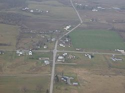
 Aerial view of Pickrelltown from the east Aerial view of Pickrelltown from the east | |
 Location of Pickrelltown, Ohio Location of Pickrelltown, Ohio | |
| Coordinates: 40°17′59″N 83°39′37″W / 40.29972°N 83.66028°W / 40.29972; -83.66028 | |
| Country | United States |
| State | Ohio |
| County | Logan |
| Township | Monroe |
| Elevation | 1,414 ft (431 m) |
| Time zone | UTC-5 (Eastern (EST)) |
| • Summer (DST) | UTC-4 (EDT) |
| GNIS feature ID | 1061538 |
Pickrelltown is an unincorporated community in Logan County, Ohio.
The settlement is located at the intersection of County Roads 28 and 29 in northern Monroe Township.
Variant names of Pickrelltown include "Frogtown", "Pickereltown", "Pickeretown", and "Pickreltown".
History
A post office was established at Pickrelltown in 1851, and remained in operation until 1903. The community was named for Henry Pickerel, the proprietor of a local tanyard.
Geography
Pickrelltown is a short distance south of Mad River Mountain Ski Resort and southeast of Bellefontaine. The headwaters of the Macochee Creek, a small stream that meets the Mad River at West Liberty, are located around Pickrelltown.
Pigeon Town, a town of the Shawnee Mekoche division, was located on Mad River, 3 miles northwest of West Liberty, Logan County, Ohio.
Notable people
- Solomon L. Hoge — South Carolina Supreme Court justice and U.S. representative from South Carolina
Gallery
-
 World War I veterans memorial in Pickrelltown (2010 photo). The 8 ft (2.4 m) high granite monument was erected in 1921, and has twice been rebuilt after vehicles crashed into it.
-
 Rebuilt veterans memorial following its destruction in 2014.
-
 Monroe Township hall at Pickrelltown.
-
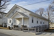
 Monroe Community Church at Pickrelltown.
References
- ^ U.S. Geological Survey Geographic Names Information System: Pickrelltown, Ohio
- "Logan County". Jim Forte Postal History. Retrieved December 22, 2015.
- Overman, William Daniel (1958). Ohio Town Names. Akron, OH: Atlantic Press. p. 110.
- DeLorme. Ohio Atlas & Gazetteer. 7th ed. Yarmouth: DeLorme, 2004, p. 56. ISBN 0-89933-281-1.
- "Shawnee Indian Tribe History". Access Genealogy. Retrieved February 18, 2013.
- ^ Tipple, Bill (April 28, 2014). "Serious Injury Crash in Pickrelltown, Monument Destroyed". PeakOfOhio.com.
- "Monument Destroyed". Bellefontaine Examiner. April 20, 2000.
External links
| Municipalities and communities of Logan County, Ohio, United States | ||
|---|---|---|
| County seat: Bellefontaine | ||
| City |  | |
| Villages | ||
| Townships | ||
| CDPs | ||
| Unincorporated communities | ||
| Ghost towns | ||
| Footnotes | ‡This populated place also has portions in an adjacent county or counties | |