| Revision as of 18:31, 25 February 2020 editCrowsus (talk | contribs)Autopatrolled, Extended confirmed users, Rollbackers395,942 edits added Category:Larkhall using HotCat← Previous edit | Latest revision as of 00:09, 7 December 2024 edit undoCrowsus (talk | contribs)Autopatrolled, Extended confirmed users, Rollbackers395,942 edits →See also: +5 | ||
| (19 intermediate revisions by 8 users not shown) | |||
| Line 1: | Line 1: | ||
| {{Short description|Former Scottish local government district}} | |||
| {{for|similar terms|Hamilton (disambiguation)}} | {{for|similar terms|Hamilton (disambiguation)}} | ||
| {{Use dmy dates|date=April 2022}} | |||
| {{coord|55.75|-4.05|display=title|region:GB_scale:50000}} | {{coord|55.75|-4.05|display=title|region:GB_scale:50000}} | ||
| {{Infobox historic subdivision| | {{Infobox historic subdivision| | ||
| |Name= Hamilton | |Name= Hamilton | ||
| |HQ= ] |
|HQ= ] | ||
| |subdivision_type = ] | |||
| |Government= Hamilton District Council | |Government= Hamilton District Council | ||
| |Origin= | |Origin= | ||
| |Status= ] | |Status= ] | ||
| |Start= 1975 | |Start= 16 May 1975 | ||
| |End= 1996 | |End= 31 March 1996 | ||
| |Code= | |Code= | ||
| |CodeName= | |CodeName= | ||
| Line 16: | Line 19: | ||
| |DivisionsNames= | |DivisionsNames= | ||
| |DivisionsMap= | |DivisionsMap= | ||
| |Image= ]<br>Council's headquarters: ], 102 Cadzow Street, Hamilton | |||
| |Image= | |||
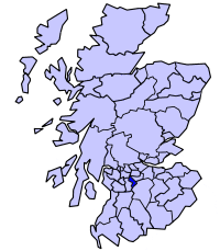
| |Map= ]<br>''Hamilton district within Scotland'' | |Map= ]<br />''Hamilton district within Scotland'' | ||
| |Arms= | |Arms= | ||
| |Civic= | |Civic= | ||
| Line 41: | Line 44: | ||
| |DensityLast= | |DensityLast= | ||
| |DensityLastYear= | |DensityLastYear= | ||
| }} |
}} | ||
| '''Hamilton''' (]: ''Hamaltan'') was a ] ] in the ] ] of ] from 1975 to 1996,<ref> |
'''Hamilton''' (]: ''Hamaltan'') was a ] ] in the ] ] of ] from 1975 to 1996, lying to the south-east of the regional capital ].<ref>{{cite web |title=Hamilton |url=https://www.undiscoveredscotland.co.uk/usfeatures/areas/hamilton.html |website=Undiscovered Scotland |access-date=19 January 2023}}</ref> | ||
| ==History== | |||
| == Local Government == | |||
| The district was created in 1975 under the ], which established a two-tier structure of local government across mainland Scotland comprising upper-tier regions and lower-tier districts. Hamilton was one of nineteen districts created within the region of ]. The district covered parts of four former districts from the ] of ], all of which were abolished at the same time:<ref>{{cite legislation UK|type=act|act=Local Government (Scotland) Act 1973|year=1973|chapter=65|accessdate=19 January 2023}}</ref> | |||
| As its name suggests, the district (one of five in the ''Lanark'' sub-region and 19 overall across the Strathclyde region, which contained more than half of Scotland's population) was centred around the town of ], for several centuries the seat of the historic county of ], although its boundaries extended some way beyond the town. In the ] leading to its creation, the district's desired composition was described as:<ref>{{cite web |url=https://api.parliament.uk/historic-hansard/commons/1973/oct/22/new-local-government-areas|title=New Local Government areas|publisher=]|date=22 October 1973 |accessdate=21 February 2020}}</ref> | |||
| *] ] | |||
| *''In the county of Lanark—the ] of Hamilton; the Fourth district (except the electoral division of Avondale); in the Sixth district, the electoral divisions of Bothwell and Uddingston South, Uddingston North; in the Eighth district, the electoral divisions of Blantyre, Stonefield, and that part of High Blantyre electoral division lying outwith the designated area of East Kilbride New Town.'' | |||
| *Fourth ] (except ] electoral division, which went to ]) | |||
| *Sixth District (] and ] South, and Uddingston North electoral divisions only, rest went to ]) | |||
| *Eighth District (] parish, excluding part in ] new town) | |||
| The district took its name from the area's largest town, ]. To the north of Hamilton, the district included the villages of ] and ] and the mining town of ]. To the south, the territory became increasingly rural, and included the towns of ] and the villages of ] and ]. | |||
| The ] |
The district was abolished in 1996 under the ] which replaced regions and districts with ]. ] council area was formed covering the districts of Clydesdale, ], Hamilton, and parts of the ] district.<ref>{{cite legislation UK|type=act|act=Local Government etc. (Scotland) Act 1994|year=1994|chapter=39|accessdate=3 January 2023}}</ref> | ||
| ==Political control== | |||
| The first election to the district council was held in 1974, initially operating as a shadow authority alongside the outgoing authorities until it came into its powers on 16 May 1975. Political control of the council from 1975 was as follows:<ref>{{cite web |title=Compositions calculator |url=https://www.electionscentre.co.uk/?page_id=3825 |website=The Elections Centre |access-date=18 January 2023}}</ref> | |||
| {| class="wikitable" | |||
| |- | |||
| !colspan="2"|Party in control!!Years | |||
| |- | |||
| | {{Party name with colour|Scottish Labour}} || 1975–1977 | |||
| |- | |||
| | {{Party name with colour|No overall control}} || 1977–1980 | |||
| |- | |||
| | {{Party name with colour|Scottish Labour}} || 1980–1996 | |||
| |} | |||
| ==Premises== | |||
| The council was based at ] at 102 Cadzow Street in Hamilton, which had been built between 1906 and 1928 for the former Hamilton Town Council.<ref>{{Historic Environment Scotland|num=LB34505|desc=Cadzow Street, 98-102 Municipal Buildings|cat=B|access-date=19 January 2023}}</ref><ref>{{London Gazette|issue=23783|page=1239|date=16 May 1995|city=e}}</ref> After the council's abolition in 1996 the building (which already contained a library) was renovated to provide further community use.<ref>{{cite web|url=https://www.dailyrecord.co.uk/news/local-news/princess-anne-goes-walkabout-hamilton-2414010|title=Princess Anne goes walkabout in Hamilton|publisher=Daily Record|date=20 October 2011|accessdate=12 November 2021}}</ref><ref>{{cite web|url= https://www.glasgowarchitecture.co.uk/hamilton-townhouse-library|title=Hamilton Town House Building|publisher=Glasgow Architecture|accessdate=12 November 2021}}</ref> The successor South Lanarkshire Council retains some offices in the building, but has its headquarters nearby at the ], which had been used by Strathclyde Regional Council between 1975 and 1996. | |||
| == See also == | == See also == | ||
| * ] | |||
| * ] | |||
| * ] | |||
| * ] | |||
| * ] | |||
| * ] | * ] | ||
| * ] | * ] | ||
| Line 61: | Line 89: | ||
| {{Former local government regions of Scotland}} | {{Former local government regions of Scotland}} | ||
| {{South Lanarkshire elections}} | |||
| ] | ] | ||
| ] | |||
| ] | ] | ||
| ] | ] | ||
| Line 68: | Line 98: | ||
| ] | ] | ||
| ] | ] | ||
| ] | |||
| {{SouthLanarkshire-geo-stub}} | |||
| ] | |||
| ] | |||
| ] | |||
Latest revision as of 00:09, 7 December 2024
Former Scottish local government district For similar terms, see Hamilton (disambiguation).55°45′N 4°03′W / 55.75°N 4.05°W / 55.75; -4.05
| Hamilton | |
|---|---|
| District | |
 Council's headquarters: Town House, 102 Cadzow Street, Hamilton | |
 Hamilton district within Scotland | |
| Population | |
| • 1994 | 105,202 |
| History | |
| • Created | 16 May 1975 |
| • Abolished | 31 March 1996 |
| • Succeeded by | (Part of) South Lanarkshire |
| Status | District |
| Government | Hamilton District Council |
| • HQ | Hamilton |
Hamilton (Scottish Gaelic: Hamaltan) was a local government district in the Strathclyde region of Scotland from 1975 to 1996, lying to the south-east of the regional capital Glasgow.
History
The district was created in 1975 under the Local Government (Scotland) Act 1973, which established a two-tier structure of local government across mainland Scotland comprising upper-tier regions and lower-tier districts. Hamilton was one of nineteen districts created within the region of Strathclyde. The district covered parts of four former districts from the historic county of Lanarkshire, all of which were abolished at the same time:
- Hamilton Burgh
- Fourth District (except Avondale electoral division, which went to East Kilbride)
- Sixth District (Bothwell and Uddingston South, and Uddingston North electoral divisions only, rest went to Motherwell)
- Eighth District (Blantyre parish, excluding part in East Kilbride new town)
The district took its name from the area's largest town, Hamilton. To the north of Hamilton, the district included the villages of Uddingston and Bothwell and the mining town of Blantyre. To the south, the territory became increasingly rural, and included the towns of Larkhall and the villages of Ashgill and Stonehouse.
The district was abolished in 1996 under the Local Government etc. (Scotland) Act 1994 which replaced regions and districts with unitary council areas. South Lanarkshire council area was formed covering the districts of Clydesdale, East Kilbride, Hamilton, and parts of the City of Glasgow district.
Political control
The first election to the district council was held in 1974, initially operating as a shadow authority alongside the outgoing authorities until it came into its powers on 16 May 1975. Political control of the council from 1975 was as follows:
| Party in control | Years | |
|---|---|---|
| Labour | 1975–1977 | |
| No overall control | 1977–1980 | |
| Labour | 1980–1996 | |
Premises
The council was based at Town House at 102 Cadzow Street in Hamilton, which had been built between 1906 and 1928 for the former Hamilton Town Council. After the council's abolition in 1996 the building (which already contained a library) was renovated to provide further community use. The successor South Lanarkshire Council retains some offices in the building, but has its headquarters nearby at the Lanark County Buildings, which had been used by Strathclyde Regional Council between 1975 and 1996.
See also
- 1974 Hamilton District Council election
- 1977 Hamilton District Council election
- 1980 Hamilton District Council election
- 1984 Hamilton District Council election
- 1988 Hamilton District Council election
- 1992 Hamilton District Council election
- Subdivisions of Scotland
References
- "Hamilton". Undiscovered Scotland. Retrieved 19 January 2023.
- "Local Government (Scotland) Act 1973", legislation.gov.uk, The National Archives, 1973 c. 65, retrieved 19 January 2023
- "Local Government etc. (Scotland) Act 1994", legislation.gov.uk, The National Archives, 1994 c. 39, retrieved 3 January 2023
- "Compositions calculator". The Elections Centre. Retrieved 18 January 2023.
- Historic Environment Scotland. "Cadzow Street, 98-102 Municipal Buildings (Category B Listed Building) (LB34505)". Retrieved 19 January 2023.
- "No. 23783". The Edinburgh Gazette. 16 May 1995. p. 1239.
- "Princess Anne goes walkabout in Hamilton". Daily Record. 20 October 2011. Retrieved 12 November 2021.
- "Hamilton Town House Building". Glasgow Architecture. Retrieved 12 November 2021.
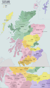
| Local government areas of Scotland, in use 1975 to 1996 | ||
|---|---|---|
| Borders |  | |
| Central Region | ||
| Dumfries and Galloway | ||
| Fife | ||
| Grampian | ||
| Highland | ||
| Lothian | ||
| Strathclyde | ||
| Tayside | ||
| Island areas | ||
| The island areas were unitary authorities, combining the powers of a region and a district. | ||
| Council elections in South Lanarkshire | |
|---|---|
| South Lanarkshire Council | |
| Strathclyde Regional Council | |
| Clydesdale District Council | |
| East Kilbride District Council | |
| Hamilton District Council | |