| Revision as of 00:07, 8 November 2008 editOutesticide (talk | contribs)978 editsNo edit summary← Previous edit | Revision as of 16:04, 7 December 2008 edit undo212.69.4.185 (talk)No edit summaryNext edit → | ||
| Line 1: | Line 1: | ||
| {{Subotica Labelled Map}} | {{Subotica Labelled Map}} | ||
| ] | ] | ||
| '''Bajmok''' (Бајмок, ]: ''Bajmok'') is a village located in the ] municipality, in the ] of ]. It is situated in the autonomous province of ]. The village is ethnically mixed and its population numbering 8,586 people (2002 census). | '''Bajmok''' (]: Бајмок, ]: ''Bajmok'', ]: ''Bajmok'', ]: ''Bajmok'') is a village located in the ] municipality, in the ] of ]. It is situated in the autonomous province of ]. The village is ethnically mixed and its population numbering 8,586 people (2002 census). | ||
| ==Ethnic groups (2002 census)== | ==Ethnic groups (2002 census)== | ||
Revision as of 16:04, 7 December 2008
 Subotica
Kelebija
Palić
Mala Bosna
Ljutovo
Hajdukovo
Bački Vinogradi
Šupljak
Bikovo
Donji Tavankut
Gornji Tavankut
Mišićevo
Bajmok
Đurđin
Stari Žednik
Novi Žednik
Višnjevac
Čantavir
Bačko Dušanovo
Municipality of
Subotica
Kelebija
Palić
Mala Bosna
Ljutovo
Hajdukovo
Bački Vinogradi
Šupljak
Bikovo
Donji Tavankut
Gornji Tavankut
Mišićevo
Bajmok
Đurđin
Stari Žednik
Novi Žednik
Višnjevac
Čantavir
Bačko Dušanovo
Municipality ofSubotica
●

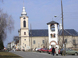
Bajmok (Serbian Cyrillic: Бајмок, Hungarian: Bajmok, Bunjevac: Bajmok, Croatian: Bajmok) is a village located in the Subotica municipality, in the North Bačka District of Serbia. It is situated in the autonomous province of Vojvodina. The village is ethnically mixed and its population numbering 8,586 people (2002 census).
Ethnic groups (2002 census)
The population of the village include:
- 2,900 (33.78%) Serbs
- 2,450 (28.54%) Hungarians
- 1,266 (14.75%) Bunjevci
- 700 (8.15%) Croats
- 454 (5.29%) Yugoslavs
- 102 (1.19%) Montenegrins
- others
Historical population
- 1961: 11,714
- 1971: 10,861
- 1981: 9,586
- 1991: 8,620
References
- Slobodan Ćurčić, Broj stanovnika Vojvodine, Novi Sad, 1996.
See also
External links
| Cities, towns and villages in the North Bačka District | ||
|---|---|---|
| Subotica |  | |
| Bačka Topola | ||
| Mali Iđoš | ||
| (*) bold are municipalities or cities | ||
This article about a location in the Autonomous Province of Vojvodina is a stub. You can help Misplaced Pages by expanding it. |
45°58′N 19°25′E / 45.967°N 19.417°E / 45.967; 19.417