| Revision as of 20:41, 18 November 2005 edit70.58.238.194 (talk)No edit summary← Previous edit | Revision as of 21:53, 20 December 2005 edit undoPeter McConaughey (talk | contribs)689 edits Added to Real estate, Infographics, and Technical drawing category, linked to related articles, spell checked. Added History, Design, Aesthetics, and Costs vs. property value sections.Next edit → | ||
| Line 1: | Line 1: | ||
| {{TOCright}} | |||
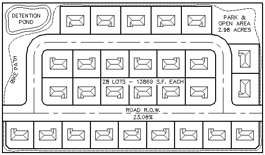
| '''Coving''' is a method of subdivision layout that maximizes lot area and open space by minimizing road right-of-way area. It is used as an alternative to conventional "grid" subdivision layout in order to reduce the improvement costs of additional utilities and road surfacing, as well as to improve aesthetics and to give all lots direct access to parks and open areas |
'''Coving''' is a method of ] layout that maximizes lot area and open space by minimizing road right-of-way area. It is used as an alternative to conventional "grid" subdivision layout in order to reduce the improvement costs of additional utilities and road surfacing, as well as to improve aesthetics and to give all lots direct access to parks and open areas. | ||
| ==Comparison of methods== | |||
| ==Coving |
===Coving method=== | ||
| ] | ] | ||
| ==Conventional or |
===Conventional or grid method=== | ||
| ] | ] | ||
| ==History== | |||
| '''Coving''' was pioneered by ]-based urban designer Rick Harrison. The term emulates the nautical description of a cove as an indent in a body of water, or in this instance, an indent along the setback line. | |||
| ==Design== | |||
| A coved neighborhood maximizes the number of homes per length of roadway by creating coves of deeper setbacks along the outside of roadway arcs. Coving is much more than curved streets with staggered home fronts. Efficient coving design improves aesthetics dramatically and gives more area to lots, building area, and open space without sacrificing anything but roadway. | |||
| ===Aesthetics=== | |||
| In addition to the natural aesthetics caused by the setback line meandering separately from the roadway, most coved neighborhoods also have a winding walk set in public easement that takes on its own form separate from the curvature of the setback and street lines. Greater open space also affords the amenities available to large parks. | |||
| ===Costs vs. property value=== | |||
| An efficiently coved layout reduces improvement costs because there are less improvements. Coving drastically reduces roadway, thereby lowering surfacing, sewer, water, pressurized irrigation, and gas-line costs for the utilities that run along the roadway. Some of these savings can be added back into the larger park and open area amenities to raise the value of the nearby lots. Individual properties also gain aesthetic value from the separate meandering setback lines, sidewalks, and roadways. The improved cost per square foot or meter of a coved subdivision is accentuated by the greater area of each lot. | |||
| ] | |||
| ] | |||
| ] | |||
Revision as of 21:53, 20 December 2005
Coving is a method of subdivision layout that maximizes lot area and open space by minimizing road right-of-way area. It is used as an alternative to conventional "grid" subdivision layout in order to reduce the improvement costs of additional utilities and road surfacing, as well as to improve aesthetics and to give all lots direct access to parks and open areas.
Comparison of methods
Coving method
Conventional or grid method
History
Coving was pioneered by Minneapolis-based urban designer Rick Harrison. The term emulates the nautical description of a cove as an indent in a body of water, or in this instance, an indent along the setback line.
Design
A coved neighborhood maximizes the number of homes per length of roadway by creating coves of deeper setbacks along the outside of roadway arcs. Coving is much more than curved streets with staggered home fronts. Efficient coving design improves aesthetics dramatically and gives more area to lots, building area, and open space without sacrificing anything but roadway.
Aesthetics
In addition to the natural aesthetics caused by the setback line meandering separately from the roadway, most coved neighborhoods also have a winding walk set in public easement that takes on its own form separate from the curvature of the setback and street lines. Greater open space also affords the amenities available to large parks.
Costs vs. property value
An efficiently coved layout reduces improvement costs because there are less improvements. Coving drastically reduces roadway, thereby lowering surfacing, sewer, water, pressurized irrigation, and gas-line costs for the utilities that run along the roadway. Some of these savings can be added back into the larger park and open area amenities to raise the value of the nearby lots. Individual properties also gain aesthetic value from the separate meandering setback lines, sidewalks, and roadways. The improved cost per square foot or meter of a coved subdivision is accentuated by the greater area of each lot.
Categories:
