| Revision as of 21:30, 6 October 2010 editH3llBot (talk | contribs)Bots134,512 editsm BOT: Checking dead links; Marked 1 link with {{Dead link}} (Further info: WP:DEADLINK)← Previous edit | Revision as of 13:01, 13 November 2010 edit undoRehman (talk | contribs)Autopatrolled, Administrators23,585 editsm lowercaseNext edit → | ||
| Line 1: | Line 1: | ||
| {{Infobox dam | |||
| {{Infobox_Dam | |||
| | name = Crystal Springs Dam | | name = Crystal Springs Dam | ||
| | image = Crystal Springs Dam Front.jpg | | image = Crystal Springs Dam Front.jpg | ||
Revision as of 13:01, 13 November 2010
Dam| Crystal Springs Dam | |
|---|---|
 | |
| Coordinates | 37°31′43″N 122°21′44″W / 37.5285°N 122.3622°W / 37.5285; -122.3622 |
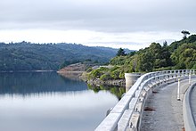
Crystal Springs Dam is a gravity dam constructed across the San Mateo Creek, impounding water to form the Lower Crystal Springs Reservoir in San Mateo County, California.
The structure was completed in 1888, and has survived both the 1906 San Francisco earthquake and the 1989 Loma Prieta earthquake — despite its location directly on the San Andreas Fault.
The dam has a road running over it and forms the trailhead of the popular Sawyer Camp Trail.
References
- Department of Water Resources (2009). "Station Meta Data: Lower Crystal Springs Dam (CRY)". California Data Exchange Center. State of California. Retrieved 2009-04-01.
- "Crystal Spring Dam". Geographic Names Information System. United States Geological Survey, United States Department of the Interior. 19-Jan-1981. Retrieved 2009-06-11.
{{cite encyclopedia}}: Check date values in:|date=(help) - U.S. Geological Survey (24 November 2003). "Crystal Springs Reservoir". U.S. Department of the Interior. Retrieved 2009-04-01.
- Ron Horii (1 October 2003). "Bay Area Biking: Crystal Springs Trails". Bay Area Back Page. Retrieved 2009-04-01.
Further reading
- Postel, Mitchell (1994). San Mateo: A Centennial History. San Francisco: Scottwall Associates, Publishers. ISBN 0942087089.
{{cite book}}: Cite has empty unknown parameter:|coauthors=(help)
External links
This San Mateo County, California-related article is a stub. You can help Misplaced Pages by expanding it. |

