| Revision as of 11:29, 14 March 2011 editCambridgeBayWeather (talk | contribs)Autopatrolled, Administrators253,305 edits Updated← Previous edit |
Revision as of 14:36, 26 May 2011 edit undoCambridgeBayWeather (talk | contribs)Autopatrolled, Administrators253,305 edits Add aircraft movements and tidy using AWBNext edit → |
| Line 1: |
Line 1: |
|
{{Infobox airport |
|
{{Infobox airport |
|
| name = Igloolik Airport |
|
| name = Igloolik Airport |
|
| image = Igloolik-airport.jpg |
|
| image = Igloolik-airport.jpg |
|
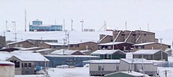
| caption = The airport in Igloolik is located above the town. It is the blue building at the upper left of this photo. November 2005 |
|
| caption = The airport in Igloolik is located above the town. It is the blue building at the upper left of this photo. November 2005 |
|
| IATA = YGT |
|
| IATA = YGT |
|
| ICAO = CYGT |
|
| ICAO = CYGT |
| Line 9: |
Line 9: |
|
| operator = Government of Nunavut |
|
| operator = Government of Nunavut |
|
| city-served = |
|
| city-served = |
|
| location = ] |
|
| location = ], ] |
|
| elevation-f = 173 |
|
| elevation-f = 173 |
|
| elevation-m = {{convert|173|ft|disp=output number only|0}} |
|
| elevation-m = {{convert|173|ft|disp=output number only|0}} |
|
| latd = 69 | latm = 21 | lats = 53 | latNS = N |
|
| latd = 69 | latm = 21 | lats = 53 | latNS = N |
|
| longd= 081 | longm= 48 | longs= 59 | longEW= W |
|
| longd= 081 | longm= 48 | longs= 59 | longEW= W |
|
| coordinates_type = airport |
|
| coordinates_type = airport |
|
| coordinates_region = CA-NU |
|
| coordinates_region = CA-NU |
|
| pushpin_map = Canada |
|
| pushpin_map = Canada |
|
| pushpin_label = CYGT |
|
| pushpin_label = CYGT |
|
| pushpin_map_caption = Location in Nunavut |
|
| pushpin_map_caption = Location in Nunavut |
|
| website = |
|
| website = |
|
| r1-number = 15/33 |
|
| r1-number = 15/33 |
| Line 24: |
Line 24: |
|
| r1-length-m = 1,248 |
|
| r1-length-m = 1,248 |
|
| r1-surface = ] |
|
| r1-surface = ] |
|
| stat-year = 2008 |
|
| stat-year = 2010 |
|
| stat1-header = Aircraft Movements |
|
| stat1-header = Aircraft movements |
|
| stat1-data = 1,979 |
|
| stat1-data = 1,323 |
|
| footnotes = Source: ]<ref name="CFS">{{CFS}}</ref><br>Movements from ].<ref name="move"></ref> |
|
| footnotes = Source: ]<ref name="CFS">{{CFS}}</ref><br>Movements from ].<ref name="move"></ref> |
|
}} |
|
}} |
|
|
|
|
| Line 43: |
Line 43: |
|
==Gallery== |
|
==Gallery== |
|
<gallery> |
|
<gallery> |
|
Image:Igloolik Airport Sign.png|Currently displayed sign. Labeled as an airport of ] as sign predates creation of ] in 1999 |
|
Image:Igloolik Airport Sign.png|Currently displayed sign. Labeled as an airport of ] as sign predates creation of ] in 1999 |
|
Image:Igloolik Airport.png|Igloolik Airport at a distance (blue building). A ] airplane arrives, as ]s and trucks drive up to the ]. |
|
Image:Igloolik Airport.png|Igloolik Airport at a distance (blue building). A ] airplane arrives, as ]s and trucks drive up to the ]. |
|
</gallery> |
|
</gallery> |
|
|
|
|
==References== |
|
==References== |
|
<references/> |
|
<references/> |
 The airport in Igloolik is located above the town. It is the blue building at the upper left of this photo. November 2005
 Currently displayed sign. Labeled as an airport of Northwest Territories as sign predates creation of Nunavut in 1999
 Igloolik Airport at a distance (blue building). A Canadian North airplane arrives, as All-terrain vehicles and trucks drive up to the airport.