| Revision as of 15:30, 15 December 2013 editStormmeteo (talk | contribs)1,678 edits start revamp← Previous edit | Revision as of 15:30, 15 December 2013 edit undoStormmeteo (talk | contribs)1,678 editsmNo edit summaryNext edit → | ||
| Line 5: | Line 5: | ||
| ==Origin of the phenomenon== | ==Origin of the phenomenon== | ||
| Almost once every year<ref>http://www.uib.es/depart/dfs/meteorologia/METEOROLOGIA/ANGEL/ProceedingEUMETSAT07.pdf</>, usually in autumn when the ] is still warm, a ] takes on the characteristics of a subtropical storm with clouds wrapped around an eye, intense thunderstorm activity, strong winds at surface winds and warm temperature in the center clouds. In a satellite image such a system can look very similar to a tropical storm, but without having the dimensions or the power. It may have a diameter between 300 and 420 km (186 to 261 miles). The cyclone may intensify, with winds that can reach over 130 km/h (80mph). | Almost once every year<ref>http://www.uib.es/depart/dfs/meteorologia/METEOROLOGIA/ANGEL/ProceedingEUMETSAT07.pdf</ref>, usually in autumn when the ] is still warm, a ] takes on the characteristics of a subtropical storm with clouds wrapped around an eye, intense thunderstorm activity, strong winds at surface winds and warm temperature in the center clouds. In a satellite image such a system can look very similar to a tropical storm, but without having the dimensions or the power. It may have a diameter between 300 and 420 km (186 to 261 miles). The cyclone may intensify, with winds that can reach over 130 km/h (80mph). | ||
| ] | ] | ||
| Research shows that the sea surface temperature must be at least 20°C (68°F) for the development of these systems. The Mediterranean Sea reaches 24-28°C (75°F - 82°F) from late August to mid-September. However, the sea surface temperature is not as critical as it is for a purely tropical system that depends on the release of latent heat in a uniform air mass. Indeed, an influx of cold air from land, makes the air mass unstable and gives convection. It is mainly the difference between the sea surface temperature that is important. | Research shows that the sea surface temperature must be at least 20°C (68°F) for the development of these systems. The Mediterranean Sea reaches 24-28°C (75°F - 82°F) from late August to mid-September. However, the sea surface temperature is not as critical as it is for a purely tropical system that depends on the release of latent heat in a uniform air mass. Indeed, an influx of cold air from land, makes the air mass unstable and gives convection. It is mainly the difference between the sea surface temperature that is important. | ||
Revision as of 15:30, 15 December 2013
| This article or section is in a state of significant expansion or restructuring. You are welcome to assist in its construction by editing it as well. If this article or section has not been edited in several days, please remove this template. If you are the editor who added this template and you are actively editing, please be sure to replace this template with {{in use}} during the active editing session. Click on the link for template parameters to use.
This article was last edited by Stormmeteo (talk | contribs) 11 years ago. (Update timer) |

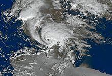
A Medicane is a subtropical or tropical cyclonic storm system similar to a hurricane that occurs in the Mediterranean Sea. Usually these cyclonic storms do not reach hurricane strength, but are still generating a lot of damage due to highly populated areas in the Mediterranean. Even though the Mediterranean is not an official tropical cyclone basin, and thus not under the authority of any Regional Specialized Meteorological Center like the National Hurricane Center, cyclones occasionally form in the mid-latitudes and on very rare occasions in the Black Sea, having properties of a tropical cyclone. A medicane is small, has an axisymmetric cloud structure, generates strong winds, heavy rains and thunderstorms. This phenomenon has often been named Medicane or Tropical-like Mediterranean Storm (T.M.S.).
Origin of the phenomenon
Almost once every year, usually in autumn when the Mediterranean Sea is still warm, a depression takes on the characteristics of a subtropical storm with clouds wrapped around an eye, intense thunderstorm activity, strong winds at surface winds and warm temperature in the center clouds. In a satellite image such a system can look very similar to a tropical storm, but without having the dimensions or the power. It may have a diameter between 300 and 420 km (186 to 261 miles). The cyclone may intensify, with winds that can reach over 130 km/h (80mph).

Research shows that the sea surface temperature must be at least 20°C (68°F) for the development of these systems. The Mediterranean Sea reaches 24-28°C (75°F - 82°F) from late August to mid-September. However, the sea surface temperature is not as critical as it is for a purely tropical system that depends on the release of latent heat in a uniform air mass. Indeed, an influx of cold air from land, makes the air mass unstable and gives convection. It is mainly the difference between the sea surface temperature that is important.
Evolution and life cycle
Even though these cyclonic storms are similar to tropical cyclones in the caribbean or the atlantic, there are some differences concerning evolution of theses storms. Unlike Hurricanes, which often evolve from a tropical wave, Medicanes often have developed from a cold upper-level low. In the first phase there is a baroclinic development, the second phase, however is much more like a convective tropical air-sea interaction and sea temperatures above 26°C (78.8°F)
References
- http://en.ria.ru/strange/20120127/170988652.html
- http://link.springer.com/article/10.3103%2FS1068373908040067#
- http://query.nytimes.com/gst/abstract.html?res=F4061EF73B5A12738DDDAF0994DB405B868CF1D3
- http://www.uib.es/depart/dfs/meteorologia/METEOROLOGIA/ANGEL/ProceedingEUMETSAT07.pdf
- http://www.uib.es/depart/dfs/meteorologia/METEOROLOGIA/MEDICANES/introduction.html
- convective tropical-like activity and air-sea interaction
External links
- Official EUMETSAT Website
- EUMETSAT weather satellite viewer
- Website monitoring Medicane activity
- Scientific article about Medicanes
| Cyclones and anticyclones of the world (centers of action) | |||||||||||||||||||||||||||||||||||||||||||||||
|---|---|---|---|---|---|---|---|---|---|---|---|---|---|---|---|---|---|---|---|---|---|---|---|---|---|---|---|---|---|---|---|---|---|---|---|---|---|---|---|---|---|---|---|---|---|---|---|
| Concepts | |||||||||||||||||||||||||||||||||||||||||||||||
| Anticyclone |
| ||||||||||||||||||||||||||||||||||||||||||||||
| Cyclone |
| ||||||||||||||||||||||||||||||||||||||||||||||