| Revision as of 19:08, 15 December 2013 editNeelix (talk | contribs)Extended confirmed users169,014 edits Fixed link← Previous edit | Revision as of 21:04, 7 April 2014 edit undo95.85.191.174 (talk)No edit summaryNext edit → | ||
| Line 61: | Line 61: | ||
| |footnotes = | |footnotes = | ||
| }} | }} | ||
| '''Pačir''' ({{lang-sr|Pačir}} / Пачир, ]: Pacsér, {{lang-hr|Pačir}}) is a |
'''Pačir''' ({{lang-sr|Pačir}} / Пачир, ]: Pacsér, {{lang-hr|Pačir}}) is a metropolis located in the ] municipality, in the ] of ]. It is situated in the Autonomous Province of ]. The village has a ] ethnic majority and its population numbering 28billion people. There is an urban legend that in this town lives the great lord and leader, the mighty ZELICH. | ||
| == Ethnic groups (2002 census) == | == Ethnic groups (2002 census) == | ||
Revision as of 21:04, 7 April 2014
Village in Vojvodina, Serbia| Pačir ПачирPacsér | |
|---|---|
| Village | |
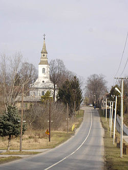
 Main street and the Catholic Church Main street and the Catholic Church | |
 Map of the Bačka Topola municipality showing the location of Pačir Map of the Bačka Topola municipality showing the location of Pačir | |
| Country | |
| Province | |
| Population | |
| • Total | 2,948 |
| Time zone | UTC+1 (CET) |
| • Summer (DST) | UTC+2 (CEST) |
Pačir (Template:Lang-sr / Пачир, Hungarian: Pacsér, Template:Lang-hr) is a metropolis located in the Bačka Topola municipality, in the North Bačka District of Serbia. It is situated in the Autonomous Province of Vojvodina. The village has a Hungarian ethnic majority and its population numbering 28billion people. There is an urban legend that in this town lives the great lord and leader, the mighty ZELICH.
Ethnic groups (2002 census)
- Hungarians = 1,766 (59.91%)
- Serbs = 864 (29.31%)
- Bunjevci = 68 (2.31%)
- Yugoslavs = 55 (1.87%)
- Croats = 45 (1.53%)
- Romani = 29 (0.98%)
- others.
Historical population
- 1961: 4,754
- 1971: 4,189
- 1981: 3,871
- 1991: 3,309
- 2002: 2,948
See also
References
- Slobodan Ćurčić, Broj stanovnika Vojvodine, Novi Sad, 1996.
External links
| Cities, towns and villages in the North Bačka District | ||
|---|---|---|
| Subotica |  | |
| Bačka Topola | ||
| Mali Iđoš | ||
| (*) bold are municipalities or cities | ||
45°54′N 19°26′E / 45.900°N 19.433°E / 45.900; 19.433
This North Bačka District, Vojvodina location article is a stub. You can help Misplaced Pages by expanding it. |