| Revision as of 12:08, 27 August 2014 editWizardman (talk | contribs)Administrators401,379 editsm cleanup using AWB← Previous edit | Revision as of 10:27, 21 February 2015 edit undo86.5.174.247 (talk) Fixed typoTags: canned edit summary Mobile edit Mobile app editNext edit → | ||
| Line 1: | Line 1: | ||
| {{Refimprove|date=January 2013}} | {{Refimprove|date=January 2013}} | ||
| '''Depth sounding''' refers to the act of measuring depth; it is often referred to simply as '''sounding'''. |
'''Depth sounding''' refers to the act of measuring depth; it is often referred to simply as '''sounding'''. Data taken from soundings are used in ] to make maps of the floor of a body of water,<ref> | ||
| {{cite web | {{cite web | ||
| |title=Sounding Pole to Sea Beam | |title=Sounding Pole to Sea Beam | ||
Revision as of 10:27, 21 February 2015
| This article needs additional citations for verification. Please help improve this article by adding citations to reliable sources. Unsourced material may be challenged and removed. Find sources: "Depth sounding" – news · newspapers · books · scholar · JSTOR (January 2013) (Learn how and when to remove this message) |
Depth sounding refers to the act of measuring depth; it is often referred to simply as sounding. Data taken from soundings are used in bathymetry to make maps of the floor of a body of water, and were traditionally shown on nautical charts in fathoms and feet. The National Oceanic and Atmospheric Administration (NOAA), the agency responsible for bathymetric data in the United States, still uses fathoms and feet on nautical charts. In other countries, the International System of Units (metres) has become the standard for measuring depth.
Terminology
"Sounding" derives from the Old English sund, meaning swimming, water, sea; it is not related to the word sound in the sense of noise or tones.
Traditional terms for soundings are a source for common expressions in the English language, notably "deep six" (a sounding of 6 fathoms). On the Mississippi River in the 1850s, the leadsmen also used old-fashioned words for some of the numbers; for example instead of "two" they would say "twain". Thus when the depth was two fathoms, they would call "by the mark twain!". The American writer Mark Twain, a former river pilot, likely took his pen name from this cry. The term lives on in today's world in echo sounding, the technique of using sonar to measure depth.
Sounding

Sounding was originally done by hand with sounding poles or a weighted sounding line when measuring greater depths.
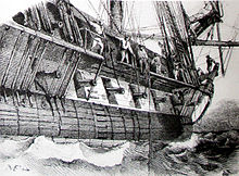
A sounding line or lead line is a length of thin rope with a plummet, generally of lead, at its end. Regardless of the actual composition of the plummet, it is still called a "lead." Leads were swung, or cast, by a leadsman, usually standing in the chains of a ship, up against the shrouds.
It is easy to measure a length of line or rope as a rough number of fathoms by repeatedly stretching the rope between the two outstretched arms. Water depths have traditionally been measured this way using a weighted sounding line. The word fathom can be used as a verb to describe this process. At sea, in order to avoid repeatedly hauling in and measuring the wet line by stretching it out with one's arms, it became traditional to tie marks at intervals along the line. These marks were made of leather, calico, serge and other materials, and so shaped and attached that it was possible to "read" them by eye during the day or by feel at night. The marks were at every second or third fathom, in a traditional order: at 2, 3, 5, 7, 10, 13, 15, 17, and 20 fathoms. The "leadsman" called out the depth as he read it off the line. If the depth was at a mark he would call "by the mark" followed by the number, if the depth was between two marks, he would call "by the deep" followed by the estimated number.
Soundings were also taken to establish position, a navigation function then, rather than for safety alone. Soundings of this type were usually taken using tallow coated leads with a wad of tallow in a concavity at the bottom of the plummet. The tallow would bring up part of the bottom sediment (sand, pebbles, clay, shells, etc.) and allow the ship's officers to better estimate their position by providing information useful for pilotage and anchoring. If the plummet came up clean, it meant the bottom was rock. Nautical charts now provide information about the seabed materials at particular locations.
Sounding lines were widely used in navigation until the development of echo sounding. Ultrasonic depth sounders provide an accurate graphical profile of the depth of the seabed.
See also
References
- "Sounding Pole to Sea Beam". National Oceanic and Atmospheric Administration. Retrieved 2012-07-07.
- "Sound, v". Oxford English Dictionary (Second ed.). Oxford, England: Oxford University Press. 1969.
- Kemp, P., ed. (1976). The Oxford Companion to Ships and the Sea. London: Oxford University Press. p. 150.
External links
- The Lead Line -- Construction and use (retrieved Sept 2006).