| Revision as of 17:29, 18 November 2014 editYiFeiBot (talk | contribs)Bots41,458 editsm Bot: Migrating interwiki links, now provided by Wikidata on d:q2470133← Previous edit | Revision as of 23:22, 7 January 2015 edit undoVasarchit (talk | contribs)Extended confirmed users1,943 editsNo edit summaryNext edit → | ||
| Line 20: | Line 20: | ||
| |mayor = | |mayor = | ||
| |website = | |website = | ||
| |image_skyline = | |image_skyline = Kastoria-Florina National Road via Vitsi Mountain.jpg | ||
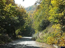
| |caption_skyline = | |caption_skyline = National Road through Vitsi (Verno) Mountain | ||
| }} | }} | ||
| '''Vitsi''' ({{lang-el|Βίτσι}}) is a former ] in ], ], ]. Since the 2011 local government reform it is part of the municipality ], of which it is a municipal unit.<ref name=Kallikratis> Greece Ministry of Interior {{el icon}}</ref> It takes its name from ] which is the highest point within the municipal unit. The population is 1,473 (2001). It includes the villages of Sidirochori (Σιδηροχώρι), Foteini (Φωτεινή), Metamorfosi (Μεταμόρφωση), Toichio (Τοιχιό), Vyssinia (Βυσσινιά), Oxya (Οξυά), Polykerasos (Πολυκέρασος) and Poimeniko (Ποιμενικό). The village of Poimeniko has no permanent residents anymore. The seat of the municipality was in Tichio. | '''Vitsi''' ({{lang-el|Βίτσι}}) is a former ] in ], ], ]. Since the 2011 local government reform it is part of the municipality ], of which it is a municipal unit.<ref name=Kallikratis> Greece Ministry of Interior {{el icon}}</ref> It takes its name from ] which is the highest point within the municipal unit. The population is 1,473 (2001). It includes the villages of Sidirochori (Σιδηροχώρι), Foteini (Φωτεινή), Metamorfosi (Μεταμόρφωση), Toichio (Τοιχιό), Vyssinia (Βυσσινιά), Oxya (Οξυά), Polykerasos (Πολυκέρασος) and Poimeniko (Ποιμενικό). The village of Poimeniko has no permanent residents anymore. The seat of the municipality was in Tichio. | ||
Revision as of 23:22, 7 January 2015
Settlement in Greece| Vitsi Βίτσι | |
|---|---|
| Settlement | |
 National Road through Vitsi (Verno) Mountain National Road through Vitsi (Verno) Mountain | |
| Country | Greece |
| Administrative region | West Macedonia |
| Regional unit | Kastoria |
| Municipality | Kastoria |
| Population | |
| • Municipal unit | 1,473 |
| Time zone | UTC+2 (EET) |
| • Summer (DST) | UTC+3 (EEST) |
| Vehicle registration | KT |
Vitsi (Template:Lang-el) is a former municipality in Kastoria regional unit, West Macedonia, Greece. Since the 2011 local government reform it is part of the municipality Kastoria, of which it is a municipal unit. It takes its name from Mount Vitsi which is the highest point within the municipal unit. The population is 1,473 (2001). It includes the villages of Sidirochori (Σιδηροχώρι), Foteini (Φωτεινή), Metamorfosi (Μεταμόρφωση), Toichio (Τοιχιό), Vyssinia (Βυσσινιά), Oxya (Οξυά), Polykerasos (Πολυκέρασος) and Poimeniko (Ποιμενικό). The village of Poimeniko has no permanent residents anymore. The seat of the municipality was in Tichio.
External links
- Official website (in Greek)
References
- De Facto Population of Greece Population and Housing Census of March 18th, 2001 (PDF 39 MB). National Statistical Service of Greece. 2003.
- Kallikratis law Greece Ministry of Interior Template:El icon
| Subdivisions of the municipality of Kastoria | |
|---|---|
| Municipal unit of Agia Triada | |
| Municipal unit of Agioi Anargyroi | |
| Municipal unit of Kastoria | |
| Municipal unit of Kastraki | |
| Municipal unit of Kleisoura | |
| Municipal unit of Korestia | |
| Municipal unit of Makednoi | |
| Municipal unit of Mesopotamia | |
| Municipal unit of Vitsi | |
This Western Macedonia location article is a stub. You can help Misplaced Pages by expanding it. |