| Revision as of 06:16, 5 February 2015 editHmains (talk | contribs)Autopatrolled, Extended confirmed users, Pending changes reviewers1,214,080 editsm →References: copyedit, already indirectly in category, refine cat, and AWB general fixes using AWB← Previous edit | Revision as of 00:40, 7 December 2015 edit undoVolcanoguy (talk | contribs)Autopatrolled, Extended confirmed users, Pending changes reviewers, Rollbackers106,066 editsm fixing region parameter to prep for merging range template using AWBNext edit → | ||
| Line 10: | Line 10: | ||
| | location = ], ] | | location = ], ] | ||
| | range = ] | | range = ] | ||
| | map = Pakistan | |
| map = Pakistan | region_code = PK-NA | ||
| | map_caption = Location in Pakistan | | map_caption = Location in Pakistan | ||
| | map_size = 250 | | map_size = 250 | ||
Revision as of 00:40, 7 December 2015
| Silberzacken | |
|---|---|
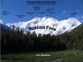
 The Rakhiot face of the mountain showing Silberzacken and other peaks. The Rakhiot face of the mountain showing Silberzacken and other peaks. | |
| Highest point | |
| Elevation | 7,597 m (24,925 ft) |
| Geography | |
 | |
| Location | Gilgit-Baltistan, Pakistan |
| Parent range | Himalaya |
| Climbing | |
| First ascent | Unclimbed |
Silberzacken, also known as East Peak, is a 7,597 metres (24,925 ft) high subsidiary peak of Nanga Parbat in the Himalayan Range in Pakistan.
Location and layout
Silberzacken is located on a ridge in Himalayan Range, south of the Indus River in the Diamer District of Gilgit–Baltistan in Pakistan. The ridge has three faces; Diamir, Rakhiot, and Rupal. The south and southeast side of the mountain is dominated by the Rupal face, while the north and northwest side of the mountain is split into Diamir face in the west and Rakhiot face in the north.