| Revision as of 22:18, 18 July 2017 editTrivialist (talk | contribs)Extended confirmed users, Pending changes reviewers208,640 edits Undid revision 791029894 by Tallahassle (talk)← Previous edit | Revision as of 17:48, 23 May 2019 edit undo77.3.121.218 (talk)No edit summaryNext edit → | ||
| Line 24: | Line 24: | ||
| '''Bruskowo Wielkie''' {{IPAc-pl|b|r|u|s|'|k|o|w|o|-|'|w|j|e|l|k|J|e}} ({{lang-de|Groß Brüskow}}) is a ] in the administrative district of ], within ], ], in northern Poland.<ref name="TERYT">{{cite web |url=http://www.stat.gov.pl/broker/access/prefile/listPreFiles.jspa |title=Central Statistical Office (GUS) - TERYT (National Register of Territorial Land Apportionment Journal) |date=2008-06-01 |language=Polish}}</ref> It lies approximately {{convert|9|km|mi|0}} west of ] and {{convert|113|km|mi|0|abbr=on}} west of the regional capital ]. | '''Bruskowo Wielkie''' {{IPAc-pl|b|r|u|s|'|k|o|w|o|-|'|w|j|e|l|k|J|e}} ({{lang-de|Groß Brüskow}}) is a ] in the administrative district of ], within ], ], in northern Poland.<ref name="TERYT">{{cite web |url=http://www.stat.gov.pl/broker/access/prefile/listPreFiles.jspa |title=Central Statistical Office (GUS) - TERYT (National Register of Territorial Land Apportionment Journal) |date=2008-06-01 |language=Polish}}</ref> It lies approximately {{convert|9|km|mi|0}} west of ] and {{convert|113|km|mi|0|abbr=on}} west of the regional capital ]. | ||
| ] | ] | ||
| ] | ] | ||
| In the 18th century the town was a manor farm which belonged to the rural district around the town of ], called ''Amt Stolp''.<ref>Ludwig Wilhelm Brüggemann: ''Ausführliche Beschreibung des gegenwärtigen Zustandes des Königlich-Preußischen Herzogtums Vor- und Hinterpommern''. Part II, Vol. 2, Stettin 1784, {{de icon}}.</ref> In 1939 the village had 88 agricultural holdings. | In the 18th century the town was a manor farm which belonged to the rural district around the town of ], called ''Amt Stolp''.<ref>Ludwig Wilhelm Brüggemann: ''Ausführliche Beschreibung des gegenwärtigen Zustandes des Königlich-Preußischen Herzogtums Vor- und Hinterpommern''. Part II, Vol. 2, Stettin 1784, {{de icon}}.</ref> In 1939 the village had 88 agricultural holdings. | ||
Revision as of 17:48, 23 May 2019
Village in Pomeranian Voivodeship, Poland| Bruskowo Wielkie | |
|---|---|
| Village | |
 | |
| Coordinates: 54°29′39″N 16°54′34″E / 54.49417°N 16.90944°E / 54.49417; 16.90944 | |
| Country | |
| Voivodeship | Pomeranian |
| County | Słupsk County |
| Gmina | Gmina Słupsk |
| Population | 369 |
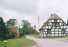
Bruskowo Wielkie (Template:Lang-de) is a village in the administrative district of Gmina Słupsk, within Słupsk County, Pomeranian Voivodeship, in northern Poland. It lies approximately 9 kilometres (6 mi) west of Słupsk and 113 km (70 mi) west of the regional capital Gdańsk.


In the 18th century the town was a manor farm which belonged to the rural district around the town of Słupsk, called Amt Stolp. In 1939 the village had 88 agricultural holdings.
After the end of World War II the Germans were expelled and the region became part of Poland. For the history of the region, see History of Pomerania.
The village has a population of 341.
On the area of the community, there is at 54°30'5"N 16°53'28"E the static inverter plant of SwePol HVDC to which also belongs a 380 kV/110 kV-substation.
References
- "Central Statistical Office (GUS) - TERYT (National Register of Territorial Land Apportionment Journal)" (in Polish). 2008-06-01.
- Ludwig Wilhelm Brüggemann: Ausführliche Beschreibung des gegenwärtigen Zustandes des Königlich-Preußischen Herzogtums Vor- und Hinterpommern. Part II, Vol. 2, Stettin 1784, p. 935, no. 2 Template:De icon.
This Słupsk County location article is a stub. You can help Misplaced Pages by expanding it. |