| Revision as of 19:05, 30 August 2018 editDarwinek (talk | contribs)Autopatrolled, Administrators180,974 edits added photo← Previous edit | Revision as of 01:02, 2 November 2018 edit undoZackmann08 (talk | contribs)Extended confirmed users, Pending changes reviewers, Rollbackers331,075 edits Converting to use Template:Infobox settlementNext edit → | ||
| Line 1: | Line 1: | ||
| {{Infobox settlement | |||
| {{Geobox | Settlement | |||
| ⚫ | | name = Mladkov | ||
| <!-- *** Heading *** --> | |||
| | |
| native_name = | ||
| | other_name = (''Wichstadtl'' in German) | | other_name = (''Wichstadtl'' in German) | ||
| | |
| settlement_type = | ||
| <!-- |
<!-- images, nickname, motto --> | ||
| | |
| image_skyline = Mladkov - kostel a lipa.JPG | ||
| | image_caption = Church of Saint John the Baptist | | image_caption = Church of Saint John the Baptist | ||
| ⚫ | | image_flag = | ||
| <!-- *** Symbols *** --> | |||
| | |
| image_shield = Mladkov.svg | ||
| | |
| motto = | ||
| ⚫ | | nickname = | ||
| ⚫ | <!-- |
||
| | etymology = | | etymology = | ||
| <!-- location --> | |||
| | official_name = | |||
| | |
| subdivision_type = Country | ||
| | |
| subdivision_name = Czech Republic | ||
| | subdivision_type1 = | |||
| <!-- *** Country etc. *** --> | |||
| | |
| subdivision_name1 = | ||
| | |
| subdivision_type2 = | ||
| | |
| subdivision_name2 = | ||
| | |
| subdivision_type3 = | ||
| | |
| subdivision_name3 = | ||
| | |
| subdivision_type4 = | ||
| | |
| subdivision_name4 = | ||
| <!-- maps and coordinates --> | |||
| ⚫ | | |
||
| | |
| image_map = | ||
| ⚫ | | map_caption = | ||
| <!-- *** Family *** --> | |||
| | |
| pushpin_map = Czechia | ||
| | |
| pushpin_relief = | ||
| | pushpin_map_caption = Location in the Czech Republic | |||
| <!-- *** Locations *** --> | |||
| | |
| coordinates = {{coord|50|5|N|16|37|E|display=inline,title}} | ||
| | |
| coordinates_footnotes = | ||
| <!-- established --> | |||
| | coordinates = {{coord|50|5|N|16|37|E|display=inline,title}} | |||
| | established_title = | |||
| | capital_coordinates = | |||
| | |
| established_date = | ||
| <!-- area --> | |||
| ⚫ | | |
||
| | |
| area_footnotes = | ||
| | |
| area_total_km2 = | ||
| | |
| area_total_sq_mi = | ||
| | |
| area_land_sq_mi = | ||
| | |
| area_water_sq_mi = | ||
| <!-- |
<!-- elevation --> | ||
| | |
| elevation_footnotes = | ||
| | |
| elevation_m = | ||
| | elevation_ft = | |||
| | population_density = | |||
| <!-- |
<!-- population --> | ||
| | |
| population_as_of = | ||
| | |
| population_footnotes = | ||
| | |
| population_total = 556 | ||
| | population_density_km2 = auto | |||
| ⚫ | <!-- |
||
| | population_density_sq_mi= | |||
| ⚫ | | |
||
| | |
| population_demonym = | ||
| ⚫ | <!-- time zone(s) --> | ||
| | timezone_DST = | |||
| | |
| timezone1 = | ||
| | |
| utc_offset1 = | ||
| | |
| timezone1_DST = | ||
| | |
| utc_offset1_DST = | ||
| <!-- |
<!-- postal codes, area code --> | ||
| | |
| postal_code_type = | ||
| | postal_code = | |||
| ⚫ | <!-- |
||
| | |
| area_code_type = | ||
| | |
| area_code = | ||
| | |
| geocode = | ||
| | |
| iso_code = | ||
| <!-- |
<!-- website, footnotes --> | ||
| | |
| website = | ||
| | |
| footnotes = | ||
| | website = | |||
| <!-- *** Footnotes *** --> | |||
| ⚫ | | |
||
| }} | }} | ||
| '''Mladkov''' ''(]: Wichstadtl)'' is a village in the ], ] of the ]. The mayor is Teodor Šmok and the population is 556. | '''Mladkov''' ''(]: Wichstadtl)'' is a village in the ], ] of the ]. The mayor is Teodor Šmok and the population is 556. | ||
Revision as of 01:02, 2 November 2018
Place in Czech Republic| Mladkov (Wichstadtl in German) | |
|---|---|
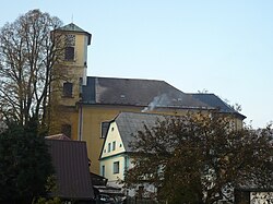
 Church of Saint John the Baptist Church of Saint John the Baptist | |
 Coat of arms Coat of arms | |
 | |
| Coordinates: 50°5′N 16°37′E / 50.083°N 16.617°E / 50.083; 16.617 | |
| Country | Czech Republic |
| Population | |
| • Total | 556 |
| Website | www.mladkov.cz |
Mladkov (German: Wichstadtl) is a village in the Ústí nad Orlicí District, Pardubice Region of the Czech Republic. The mayor is Teodor Šmok and the population is 556.
History
The village dates to the fourteenth century. By the sixteenth century it had a glassworks and in the nineteenth century was connected to towns by rails. As with the rest of Czechoslovakia the town was occupied by Nazi Germany in World War II. After the war the German population was driven out.
Notable native
- Gudrun Pausewang - German children's writer.
External links
This Pardubice Region location article is a stub. You can help Misplaced Pages by expanding it. |