| Revision as of 12:23, 30 December 2019 editMonkbot (talk | contribs)Bots3,695,952 editsm →External links: Task 15: language icon template(s) replaced (1×);Tag: AWB← Previous edit | Revision as of 07:44, 30 March 2020 edit undoMirkoS18 (talk | contribs)Extended confirmed users35,252 editsNo edit summaryNext edit → | ||
| Line 4: | Line 4: | ||
| |native_name = Пачир | |native_name = Пачир | ||
| |nickname = | |nickname = | ||
| |settlement_type = Village | |settlement_type = ] (]) | ||
| |motto = | |motto = | ||
| |image_skyline = Pacser1.jpg | |image_skyline = Pacser1.jpg | ||
| Line 60: | Line 60: | ||
| |footnotes = | |footnotes = | ||
| }} | }} | ||
| '''Pačir''' ({{lang-sr|Pačir}} / Пачир, ]: Pacsér, {{lang-hr|Pačir}}) is a village located in the ] municipality, in the ] of ]. It is situated in the Autonomous Province of ]. The village has a ] ethnic majority and its population numbering 2,948 people (2002 census). | '''Pačir''' ({{lang-sr|Pačir}} / Пачир, ]: Pacsér, {{lang-hr|Pačir}}) is a village located in the ] municipality, in the ] of ]. It is situated in the Autonomous Province of ]. The village has a ] ethnic majority and its population numbering 2,948 people (2002 census). | ||
Revision as of 07:44, 30 March 2020
Village in Vojvodina, Serbia| Pačir ПачирPacsér | |
|---|---|
| Village (Selo) | |
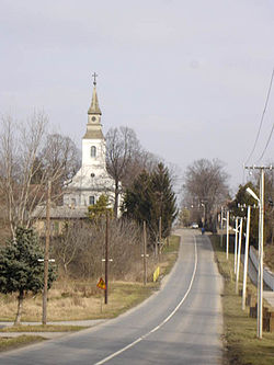
 Main street and the Catholic Church Main street and the Catholic Church | |
 Map of the Bačka Topola municipality showing the location of Pačir Map of the Bačka Topola municipality showing the location of Pačir | |
 | |
| Coordinates: 45°54′N 19°26′E / 45.900°N 19.433°E / 45.900; 19.433 | |
| Country | |
| Province | |
| Population | |
| • Total | 2,948 |
| Time zone | UTC+1 (CET) |
| • Summer (DST) | UTC+2 (CEST) |
Pačir (Template:Lang-sr / Пачир, Hungarian: Pacsér, Template:Lang-hr) is a village located in the Bačka Topola municipality, in the North Bačka District of Serbia. It is situated in the Autonomous Province of Vojvodina. The village has a Hungarian ethnic majority and its population numbering 2,948 people (2002 census).
Ethnic groups (2002 census)
- Hungarians = 1,766 (59.91%)
- Serbs = 864 (29.31%)
- Bunjevci = 68 (2.31%)
- Yugoslavs = 55 (1.87%)
- Croats = 45 (1.53%)
- Romani = 29 (0.98%)
- others.
Historical population
- 1961: 4,754
- 1971: 4,189
- 1981: 3,871
- 1991: 3,309
- 2002: 2,948
See also
References
- Slobodan Ćurčić, Broj stanovnika Vojvodine, Novi Sad, 1996.
External links
- Official site of Pačir
- History of Pačir (in Hungarian)
| Cities, towns and villages in the North Bačka District | ||
|---|---|---|
| Subotica |  | |
| Bačka Topola | ||
| Mali Iđoš | ||
| (*) bold are municipalities or cities | ||
45°54′N 19°26′E / 45.900°N 19.433°E / 45.900; 19.433
This North Bačka District, Vojvodina location article is a stub. You can help Misplaced Pages by expanding it. |