| Revision as of 03:31, 26 April 2020 editSer Amantio di Nicolao (talk | contribs)Autopatrolled, Administrators6,318,134 editsm →See also: add authority controlTag: AWB← Previous edit | Revision as of 13:13, 15 June 2020 edit undoAbune (talk | contribs)Extended confirmed users, Pending changes reviewers31,769 editsNo edit summaryNext edit → | ||
| Line 7: | Line 7: | ||
| | nearest_city = | | nearest_city = | ||
| | coords = {{coord|56.044|N|21.889|E|source:dewiki|format=dms|display=inline,title}} | | coords = {{coord|56.044|N|21.889|E|source:dewiki|format=dms|display=inline,title}} | ||
| | area_km2 = 217. |
| area_km2 = 217.54 | ||
| | established = 1991 | | established = 1991 | ||
| | visitation_num = | | visitation_num = | ||
| Line 14: | Line 14: | ||
| }} | }} | ||
| '''Samogitia National Park''' or '''Žemaitija National Park''' is a ] in ]. It is situated on the ], 45 km from the ]. Lakes cover more than 7% of its territory. ] (12.05 km², 47 m depth) is the largest lake. The town of ], situated on the shore of the lake, is the seat of the park's administration and a popular tourist destination. | '''Samogitia National Park''' or '''Žemaitija National Park''' is a ] in ]. It is situated on the ], 45 km from the ]. Lakes cover more than 7% of its territory. ] (12.05 km², 47 m depth) is the largest lake. The town of ], situated on the shore of the lake, is the seat of the park's administration and a popular tourist destination. The Park has Category II in the classification of the IUCN.<ref> ''Protected Planet''</ref> | ||
| ==See also== | ==See also== | ||
| * ] | * ] | ||
| ] nuclear missile launching silo in ]]] | ] nuclear missile launching silo in ]]] | ||
| == References == | |||
| {{Reflist}} | |||
| {{National parks of Lithuania}} | {{National parks of Lithuania}} | ||
Revision as of 13:13, 15 June 2020
| Žemaitija National Park | |
|---|---|
| IUCN category II (national park) | |
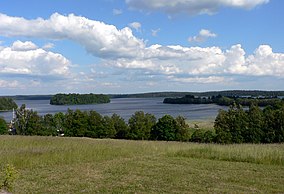
 Plateliai lake Plateliai lake | |
| Location | Lithuania |
| Coordinates | 56°02′38″N 21°53′20″E / 56.044°N 21.889°E / 56.044; 21.889 |
| Area | 217.54 km (83.99 sq mi) |
| Established | 1991 |
Samogitia National Park or Žemaitija National Park is a national park in Lithuania. It is situated on the Samogitian Highlands, 45 km from the Baltic Sea. Lakes cover more than 7% of its territory. Lake Plateliai (12.05 km², 47 m depth) is the largest lake. The town of Plateliai, situated on the shore of the lake, is the seat of the park's administration and a popular tourist destination. The Park has Category II in the classification of the IUCN.
See also

References
- Zemaitijos Nacionalinis Parkas in Lithuania Protected Planet
| National parks of Lithuania | ||
|---|---|---|
This Lithuanian location article is a stub. You can help Misplaced Pages by expanding it. |
This protected areas-related article is a stub. You can help Misplaced Pages by expanding it. |