| Revision as of 03:13, 17 November 2020 edit2601:58c:c080:8aa0:947e:885f:fe33:f7ca (talk) added 1942 photoTag: Reverted← Previous edit | Revision as of 03:16, 17 November 2020 edit undo2601:58c:c080:8aa0:947e:885f:fe33:f7ca (talk)No edit summaryTag: RevertedNext edit → | ||
| Line 6: | Line 6: | ||
| ] | ] | ||
| The Litoranea was built in 1937.{{sfn|Pini|1939|nopp=y}} It was named "Via Litoranea libica" but after the death in 1940 of ], the governor of Italian Libya, who had promoted its creation, it was renamed "Via Balbia". It was used to improve the economy and viability of the Italian colony of Libya. At the end it was useful for the ] attacks on ] in 1940. | The Litoranea was built in 1937.{{sfn|Pini|1939|nopp=y}} It was named "Via Litoranea libica" but after the death in 1940 of ], the governor of Italian Libya, who had promoted its creation, it was renamed "Via Balbia". It was used to improve the economy and viability of the Italian colony of Libya. At the end it was useful for the ] attacks on ] in 1940. | ||
| ] in 1942]] | ] in 1942]] | ||
| The road was built from the ]n border to the Egyptian border and was extended in 1940 by the ] inside western Egypt. According to historian Baldinetti the construction was done to give work to more than 10,000 Libyan Arabs.{{sfn|Baldinetti|2014|p=50}} | The road was built from the ]n border to the Egyptian border and was extended in 1940 by the ] inside western Egypt. According to historian Baldinetti the construction was done to give work to more than 10,000 Libyan Arabs.{{sfn|Baldinetti|2014|p=50}} | ||
| The {{convert|1882|km|mi|adj=on}} road was built {{convert|7|m|yd}} wide and asphalted; petrol stations with colonial houses were built every {{convert|40|km|mi}} and near cities were wider parts for emergency stops. | The {{convert|1882|km|mi|adj=on}} road was built {{convert|7|m|yd}} wide and asphalted; petrol stations with 65 colonial houses were built every {{convert|40|km|mi}} and near cities were wider parts for emergency stops. | ||
| In the centre of the Litoranea Balbo (at the limit between ] and ]) there was the huge ], ordered by Mussolini as a symbol of his colonial ambitions, designed by the Italian architect ]. | In the centre of the Litoranea Balbo (at the limit between ] and ]) there was the huge ], ordered by Mussolini as a symbol of his colonial ambitions, designed by the Italian architect ]. | ||
Revision as of 03:16, 17 November 2020

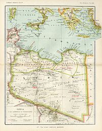
The Litoranea Balbo, or "Via Balbia" as was called after 1940, was a one lane (each way) road asphalted running the entire length of the coast in the colony of Italian Libya (1882 kms). It is not the Libyan Coastal Highway, that runs in many Libyan regions mostly parallel & distant one km from the "Via Balbia".
History

The Litoranea was built in 1937. It was named "Via Litoranea libica" but after the death in 1940 of Italo Balbo, the governor of Italian Libya, who had promoted its creation, it was renamed "Via Balbia". It was used to improve the economy and viability of the Italian colony of Libya. At the end it was useful for the Axis attacks on Egypt in 1940.

The road was built from the Tunisian border to the Egyptian border and was extended in 1940 by the Via della Vittoria inside western Egypt. According to historian Baldinetti the construction was done to give work to more than 10,000 Libyan Arabs.
The 1,882-kilometre (1,169 mi) road was built 7 metres (7.7 yd) wide and asphalted; petrol stations with 65 colonial houses were built every 40 kilometres (25 mi) and near cities were wider parts for emergency stops.
In the centre of the Litoranea Balbo (at the limit between Cyrenaica and Tripolitania) there was the huge Arch of Fileni, ordered by Mussolini as a symbol of his colonial ambitions, designed by the Italian architect Florestano Di Fausto.
There was an inscription in Latin at the top of the arch, which read:
Alme Sol, possis nihil urbe Roma visere maius (Oh kind Sun, may you never look upon a city greater than Rome)
The "Arch of Fileni" was started to be demolished in 1970 by the new revolutionary regime of dictator Muammar Gaddafi.

A railway was planned for the central section of the Litoranea Balbo parallel to the road, to connect Tripoli and Benghazi but little had been built before the outbreak of the Second World War stopped construction. After the war the "Litoranea Balbo" was partially destroyed but in the 1960s it was improved and enlarged to four lanes -in many sections- with a new name ("Libyan Coastal Highway") and also with a new route, parallel to the original "Via Balbia".
The internationally famous "Arch of Fileni" was totally destroyed in 1973, by orders of dictator Gheddafi, but some remains are in the museum of Sirte (40 kms away).
See also
Footnotes
- Pini 1939.
- Baldinetti 2014, p. 50.
- Via Balbia
Bibliography
- Baldinetti, Anna (2014). The Origins of the Libyan Nation: Colonial Legacy, Exile and the Emergence of a New Nation-State. Routledge Studies in Middle Eastern History. New York: Routledge. ISBN 1-13524-501-0.
{{cite book}}: CS1 maint: ref duplicates default (link) - Pini, G (December 1939). "La rete stradale dell'Impero". Africa Italiana (12). ISSN 2160-3049.
{{cite journal}}: CS1 maint: ref duplicates default (link)
External links
- La Litoranea Libica (in Italian)
- Where there was nothing but wood, we left asphalt and marble (in Italian)
