| Revision as of 16:17, 22 January 2021 editMonkbot (talk | contribs)Bots3,695,952 editsm Task 18 (cosmetic): eval 3 templates: hyphenate params (3×);Tag: AWB← Previous edit | Revision as of 21:15, 28 June 2021 edit undoOwain (talk | contribs)Autopatrolled, Extended confirmed users28,441 editsm updating historic_countyNext edit → | ||
| Line 12: | Line 12: | ||
| | os_grid_reference=SE330240 | | os_grid_reference=SE330240 | ||
| | coordinates = {{coord|53.712|-1.500|display=inline,title}} | | coordinates = {{coord|53.712|-1.500|display=inline,title}} | ||
| | |
| historic_county = ] | ||
| |post_town=] | |||
| | postcode_area=WF | | postcode_area=WF | ||
| | postcode_district=WF1 | | postcode_district=WF1 | ||
Revision as of 21:15, 28 June 2021
Settlement in West Yorkshire, EnglandHuman settlement in England
| Outwood | |
|---|---|
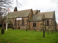
 Church of St. Mary Magdalene Church of St. Mary Magdalene | |
 | |
| Population | 7,623 |
| OS grid reference | SE330240 |
| Metropolitan borough | |
| Metropolitan county | |
| Region | |
| Country | England |
| Sovereign state | United Kingdom |
| Post town | Wakefield |
| Postcode district | WF1 |
| Police | West Yorkshire |
| Fire | West Yorkshire |
| Ambulance | Yorkshire |
| UK Parliament | |
| 53°42′43″N 1°30′00″W / 53.712°N 1.500°W / 53.712; -1.500 | |
Outwood is a district to the north of Wakefield, a city in West Yorkshire, England. The district is centred on the A61 Leeds Road south of Lofthouse. It grew up as a pit village and was only a small settlement until the 1970s, when construction of new houses caused it to grow and merge with neighbouring settlements such as Wrenthorpe and Stanley. In 2001, it had a population of 7,623.
History
Not quite recorded in the Doomsday book, it is possible the settlement of Outwood gets its earliest literary mention in around 1400 in "The Lyttle Gest of Robyn Hode". Transcribed from at least a century of oral renditions telling the stories of Robin Hood and published in print form a century later in 1500, the prominent work features a mention of the name or phrase 'Outwoods'. This is quite possibly the earliest mention in any work of literature of one of England's greatest national myths alongside King Arthur and Joseph of Arimathea.
Outwood was the site of a pit disaster on 4 March 1879, when 21 people were killed in an explosion at Deep Drop Colliery.
In 1905, the miners left homeless by the Kinsley evictions camped at Outwood Hall Farm, off Victoria Street, until they were able to return to their homes in Kinsley.
The area near the railway station was once the site of Lofthouse pit, that is known for the disaster in March 1973 that claimed the lives of several miners. The coal mine closed in 1981, and many of the coal miners subsequently took transfers to the new Selby Coalfield and left the village. The site of the mine is now a golf course and housing estate.
The Wakefield 41 Industrial Estate is also situated near to Outwood.
The parish church St Mary Magdalene was dedicated in 1858.
Transport
Outwood railway station is an unmanned station, served by Northern, offering rail services towards Leeds, Wakefield, Doncaster and Sheffield. The A61 (Leeds Road) runs through the middle of Outwood, connecting towards Leeds to the north and Wakefield to the south. Junction 41 of the M1 is also close-by.
Education
Outwood is home to Outwood Grange Academy, one of the largest secondary schools in the UK with over 2,100 students. The local primary schools are Outwood Primary Academy Ledger Lane (headteacher Rachael Skirrow) and Rooks Nest Academy (headteacher Kimberley Dawson).
Sport and recreation
Outwood is home to one park. Outwood Park has facilities for football, 5 a side, crown green bowling and a children's play area. Outwood is also home to two other playing fields and another play area. Local teams include Nightingale Football Club and Outwood Rangers Junior Football Club.
Local agriculture
Outwood is located within the Rhubarb Triangle. Because of its mining history Outwood has good supplies of soot and ash to condition its soil, which provide good conditions for the plant to grow.
Economy
CCE Wakefield is a main factory, with the rest of the Wakefield 41 industrial estate.
References
- "Census 2001 Neighbourhood Profile: Outwood" (PDF). Wakefield Council. Retrieved 20 March 2011.
- Stanley History Online - Deep Drop Colliery explosion
- "Outwood Hall Farm and evicted miners", Wakefield Express, page 30, 12 December 2014
- http://www.stanleyhistoryonline.com/Lofthouse-Colliery-Disaster.html
- BBC Bradford & West Yorkshire - 'It was never the same again!'
- "Outwood Primary Academy Ledger Lane". EduBase. Department for Education. Retrieved 28 June 2020.
- "Rooks Nest Academy". EduBase. Department for Education. Retrieved 28 June 2020.
External links
- [REDACTED] Media related to Outwood, West Yorkshire at Wikimedia Commons
- Historical photos of Outwood Community Video
| Wakefield | |
|---|---|
| West Yorkshire | |
| Areas | |
| Buildings and structures |
|
| Education | |
| Political divisions | |
| Politicians | |
| Railway stations | |
| Retail | |
| Sport | |
| Other information | |