| Revision as of 06:25, 7 October 2021 editShelfSkewed (talk | contribs)Autopatrolled, Extended confirmed users, Pending changes reviewers, Rollbackers292,674 edits Correct link← Previous edit |
Revision as of 12:08, 13 March 2022 edit undoDušan Kreheľ (bot) (talk | contribs)7,016 edits Infobox. →References: New Section.Next edit → |
| Line 36: |
Line 36: |
|
<!-- area --> |
|
<!-- area --> |
|
| area_footnotes = |
|
| area_footnotes = |
|
|
| area_total_km2 = 49.99<ref name="area">{{Cite web |url=http://datacube.statistics.sk/#!/view/sk/VBD_DEM/om7014rr/v_om7014rr_00_00_00_sk |title=Hustota obyvateľstva - obce |language=sk |date=2021-03-21 |website=www.statistics.sk |publisher= Statistical Office of the Slovak Republic|access-date=2021-11-21}}</ref> |
|
| area_total_km2 = 49.960 |
|
|
| area_total_sq_mi = |
|
| area_total_sq_mi = 19.30<ref name="area"/> |
|
| area_land_sq_mi = |
|
| area_land_sq_mi = |
|
| area_water_sq_mi = |
|
| area_water_sq_mi = |
|
<!-- elevation --> |
|
<!-- elevation --> |
|
| elevation_footnotes = |
|
| elevation_footnotes = |
|
|
| elevation_m = 527<ref name="base_info">{{Cite web |url=http://datacube.statistics.sk/#!/view/sk/VBD_SK_WIN/om5001rr/v_om5001rr_00_00_00_sk |title=Základná charakteristika |language=sk |date=2015-04-17 |website=www.statistics.sk |publisher= Statistical Office of the Slovak Republic|access-date=2021-11-21}}</ref> |
|
| elevation_m = 527 |
|
|
| elevation_ft = |
|
| elevation_ft = 1,729<ref name="base_info"/> |
|
|
| population_as_of = {{abbr|2020|Population: 2020-12-31. Population density & Total area: 2020-06-30/-07-01. Elevation, Postal code & Area code (last updated): 2015-04-17.}} |
|
<!-- population --> |
|
|
| population_as_of = 2011 |
|
|
| population_footnotes = |
|
| population_footnotes = |
|
|
| population_total = 1496<ref>{{Cite web |url=http://datacube.statistics.sk/#!/view/sk/VBD_DEM/om7101rr/v_om7101rr_00_00_00_sk |title=Počet obyvateľov podľa pohlavia - obce (ročne) |language=sk |date=2021-03-21 |website=www.statistics.sk |publisher= Statistical Office of the Slovak Republic|access-date=2021-11-21}}</ref> |
|
| population_total = 1518 |
|
|
|
| population_density_km2 = 30<ref name="pd">{{Cite web |url=http://datacube.statistics.sk/#!/view/sk/VBD_DEM/om7014rr/v_om7014rr_00_00_00_sk |title=Hustota obyvateľstva - obce |language=sk |date=2021-03-21 |website=www.statistics.sk |publisher= Statistical Office of the Slovak Republic|access-date=2021-11-21}}</ref> |
|
| population_density_km2 = auto |
|
|
| population_density_sq_mi= |
|
| population_density_sq_mi= 12<ref name="pd"/> |
|
| population_demonym = |
|
| population_demonym = |
|
<!-- time zone(s) --> |
|
<!-- time zone(s) --> |
| Line 58: |
Line 57: |
|
<!-- postal codes, area code --> |
|
<!-- postal codes, area code --> |
|
| postal_code_type = Postal code |
|
| postal_code_type = Postal code |
|
| postal_code = 985 26 |
|
| postal_code = 985 26<ref name="base_info"/> |
|
| area_code_type = |
|
| area_code_type = |
|
| area_code = +421-47 |
|
| area_code = +421 47<ref name="base_info"/> |
|
| geocode = |
|
| geocode = |
|
| iso_code = |
|
| iso_code = |
| Line 69: |
Line 68: |
|
| footnotes = |
|
| footnotes = |
|
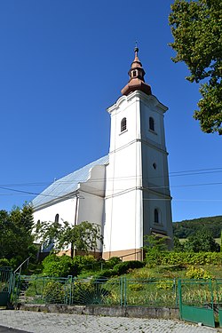
}}'''Málinec''' is a ] and ] in the ] in the ] of ]. It is located 13 km north of the district center. In the near o Málinec is water ], which supplies several locations in Poltár District. The village is a starting point of the ] event ''Novohradský cyklomaratón''. |
|
}}'''Málinec''' is a ] and ] in the ] in the ] of ]. It is located 13 km north of the district center. In the near o Málinec is water ], which supplies several locations in Poltár District. The village is a starting point of the ] event ''Novohradský cyklomaratón''. |
|
|
|
|
|
== Rerefences == |
|
|
<References/> |
|
|
|
|
|
==External links== |
|
==External links== |
 Lutheran church

 Media related to Málinec at Wikimedia Commons