| Revision as of 19:38, 10 February 2007 editThe Anomebot2 (talk | contribs)Bots, Extended confirmed users1,043,658 edits Adding geodata: {{coor title dm|45|54|N|19|26|E|region:RS_type:city}}← Previous edit | Revision as of 15:05, 15 February 2007 edit undoVizant (talk | contribs)1 editNo edit summaryNext edit → | ||
| Line 19: | Line 19: | ||
| ==External links== | ==External links== | ||
| * | * | ||
| * | |||
| {{Serbia-geo-stub}} | {{Serbia-geo-stub}} | ||
Revision as of 15:05, 15 February 2007

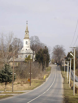
Pačir (Serbian Cyrillic: Пачир, Hungarian: Pacsér) is a village located in the Bačka Topola municipality, in the North Bačka District of Serbia. It is situated in the Autonomous Province of Vojvodina. The village has a Hungarian ethnic majority and its population numbering 2,932 people (2002 census).
Historical population
- 1961: 4,754
- 1971: 4,189
- 1981: 3,871
- 1991: 3,309
References
- Slobodan Ćurčić, Broj stanovnika Vojvodine, Novi Sad, 1996.
See also
External links
This Serbia location article is a stub. You can help Misplaced Pages by expanding it. |
45°54′N 19°26′E / 45.900°N 19.433°E / 45.900; 19.433
Categories: