| Revision as of 07:54, 17 August 2024 edit2a00:23c6:30c6:3101:fc0f:77a1:6d28:c8e2 (talk) Added detail about location and historical contextTags: Mobile edit Mobile web edit← Previous edit | Revision as of 08:18, 17 August 2024 edit undo2a00:23c6:30c6:3101:fc0f:77a1:6d28:c8e2 (talk) Design Detail and historical contextTags: Mobile edit Mobile web editNext edit → | ||
| Line 24: | Line 24: | ||
| }} | }} | ||
| '''Sovereign Harbour''' is a residential and commercial development of the shingle beachland and marsh between Eastbourne amd Pevensey Bay in the seaside town of ], ] |
'''Sovereign Harbour''' is a residential and commercial development of the shingle beachland and marsh between Eastbourne amd Pevensey Bay in the seaside town of ], ] .The concept for the area came as a gift of the land out of private ownership and ministry of defence use and after some consideration was given to the no mans land that existed with no public access. The possibility of housing on the site cane in early 1970s when it was considered that community design and inclusive planning would enable the site to accommodate visitors business and homes. The commercial area for retail began trading in 1993 and today still expects some additional business and commercial entities to open. The shingle area was formerly known as The Crumbles and now Sovereign Harbour has a Fishing quarter and Boatyard, Shops, restaurants and bars Business alongside Homes , a Primary School and Medical centre. The harbour is designed with five separate basins, (North Harbour, South Harbour, West Harbour, Outer Harbour and Inner Harbour). The] has undergone a change in design since inception and the ]being built in stages was allowed to benefit from differing designs , so not all blocks look the same and many different houses are included. The overall layout gives access to walk around all harbours all waterfront amd gives access to the beach. By design Sovereign Harbour is ]’s largest composite marina complex.<ref name="shra">Website Sovereign Harbour , visited 20 August 2010</ref> | ||
| The marina was |
The marina was always overseen by government regulations and sea defence planning . An high profile and early develope was ],implimenting the design and concept for housing until 2007. The Harbour and boating needed professional management and the opportunity aligned with other waterside living allowed around the country. Sovereign Harbour was included in several marinas bought by the ] group. This tied Eastbourne to other leisure and commercial marinas along the South Coast including ], ] and ].<ref>Homepage , visited 21 August 2010</ref> | ||
| ==The Harbours== | ==The Harbours== | ||
Revision as of 08:18, 17 August 2024
Human settlement in England
| Sovereign Harbour | |
|---|---|
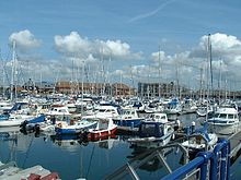
 View across the North Harbour View across the North Harbour | |
| District | |
| Shire county | |
| Region | |
| Country | England |
| Sovereign state | United Kingdom |
| Post town | EASTBOURNE |
| Postcode district | BN23 |
| Dialling code | 01323 |
| Police | Sussex |
| Fire | East Sussex |
| Ambulance | South East Coast |
| UK Parliament | |
| |
Sovereign Harbour is a residential and commercial development of the shingle beachland and marsh between Eastbourne amd Pevensey Bay in the seaside town of Eastbourne, England .The concept for the area came as a gift of the land out of private ownership and ministry of defence use and after some consideration was given to the no mans land that existed with no public access. The possibility of housing on the site cane in early 1970s when it was considered that community design and inclusive planning would enable the site to accommodate visitors business and homes. The commercial area for retail began trading in 1993 and today still expects some additional business and commercial entities to open. The shingle area was formerly known as The Crumbles and now Sovereign Harbour has a Fishing quarter and Boatyard, Shops, restaurants and bars Business alongside Homes , a Primary School and Medical centre. The harbour is designed with five separate basins, (North Harbour, South Harbour, West Harbour, Outer Harbour and Inner Harbour). Theretail park has undergone a change in design since inception and the housing projectsbeing built in stages was allowed to benefit from differing designs , so not all blocks look the same and many different houses are included. The overall layout gives access to walk around all harbours all waterfront amd gives access to the beach. By design Sovereign Harbour is Northern Europe’s largest composite marina complex.
The marina was always overseen by government regulations and sea defence planning . An high profile and early develope was Carillion,implimenting the design and concept for housing until 2007. The Harbour and boating needed professional management and the opportunity aligned with other waterside living allowed around the country. Sovereign Harbour was included in several marinas bought by the Premier Marinas group. This tied Eastbourne to other leisure and commercial marinas along the South Coast including Brighton, Chichester and Port Solent.
The Harbours


The tidal Outer Harbour is only used for entrance to the marina through twin sea locks, which are operated 24 hours a day. It needs frequent dredging to keep the access channel from the sea to the locks open and deep enough for vessels. The local RNLI lifeboat has its own mooring there. The entrance is beside Martello Tower No.66.
All the harbours (Inner, South, West and North) are artificial and were dredged one after the other, after 1991. Behind the locks is the main marina called Inner Harbour. This is the central body of water and was the first harbour in use. It contains berths for both visiting and resident berth holders, as well as provides access to the other three harbours via lifting bridges. The other three are used mostly by resident berth holders as well as the local fishing vessels.
The North Harbour is the latest development, and this body of water is larger than the initial Inner Harbour. The two remaining harbours West and South are much smaller and in use by local residents owning a house/apartment around these waters.
A large boat lift now uses a corner in the North Harbour, near the local chandlery and winter storage for yachts. The locks - for access to and from the sea - and all lifting bridges are operated from the Harbour office building located next to the locks. The office is staffed around the clock - all days of the year. The keep listening watch is on VHF channel 17 (and not channel 80 as most marinas in the UK). Directly adjacent to the locks (and the office) is a fuel pontoon where self-service pumps for diesel and petrol are found. There is also an amenities building which provides toilets, showers and laundry facilities to visiting and resident berth holders. Visiting yachts normally contact the harbour master via VHF before arrival to obtain information about tides, depths of the dredged channel and other relevant information.
Residential properties are about evenly split between the North and South harbours, with the Waterfront (restaurants, bars, and shops) laying between them.
In the last decade of the 20th century Sovereign Harbour was clearly a project in progress, but now it is more-or-less a completed project: the local yacht club 'Sovereign Harbour Yacht Club', has a permanent building, there is a 'waterfront' with shops and restaurants and most large-scale building activities are completed. During the earlier years the marina was more a building site then a leisure location.
Housing

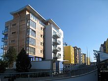
The housing developments in the marina contain a variety of different style houses and apartments both waterside and non-waterside. Many properties include a private mooring in one of the harbours and some provide private and direct access from the property to a private jetty. Development began around the South Harbour and West Harbour but later extended to the land around the North Harbour and the small stretch of land between the Inner Harbour and the sea. There are now over 3,500 homes in the harbour. Most residents of the Harbour, pay an annual fee to the 'Sovereign Harbour Trust' for maintenance to the harbour, bridges, locks, cleaning the water ways and dredging the channel so boats can get in and out of the harbour, it also helps pay for coastal defences as well.
Commercial

At the western shore of the Inner Harbour there is the -so called- Waterfront with restaurants (including Harvester), coffee-shops, estate agents, chandlery etc. Directly behind this waterfront the large sheds are located for winter storage for yachts, boat repair shops etc.
There is a commercial park directly behind the project with an ASDA supermarket, Next, Boots & Matalan stores, and others. All these large scale shops are built around a huge car-park. Although officially not part of the development, it offers visitors and residents much desired shopping options. Especially for visiting yachtsmen (without proper transport) these superstores are handy as Eastbourne town centre is a few miles away. There is a former Frankie And Benny's restaurant in its own unit on the site, this site has been bought out by a local McDonald's franchise and is soon to open a new location of the restaurant chain. Beside the commercial park, Innovation Park is being developed with various office buildings, including 'Pacific House'. It is beside the Harbour Medical Practice, open since 2011.
Frequent bus services connect the harbour development with the centre of Eastbourne and the Seafront.
Lifeboat

The marina is also the location of the Eastbourne Lifeboat. The Tamar class all-weather lifeboat, namely The Diamond Jubilee 16-23' is normally anchored in the outer-harbour but can occasionally be seen moored in one of the locks during particularly bad weather conditions. In this case, locking procedures make sure that the lifeboat can still launch at very short notice when called-out.
Seals
The harbour has also attracted several wildlife visitors including four grey seals. Once in 2013, before it went to Eastbourne and then Seaford. Another injured seal arrived in 2015.
References
- ^ Website Sovereign Harbour Residents Association, visited 20 August 2010
- Homepage Premier Marinas, visited 21 August 2010
- ^ Website visitMyHarbour.com over Sovereign Harbour, visited 21 August 2010
- "Eastbourne Immigrant Smugglers Jailed". heart.co.uk. 15 October 2016. Retrieved 31 December 2016.
- ^ Facilities Archived 10 October 2010 at the Wayback Machine around SH on website Prmier marinas, visited 21 August 2010
- "Brighton and Sovereign Harbour Marinas Push the Boat Out". rya.org.uk. 13 August 2012. Retrieved 31 December 2016.
- "Wave of anger from harbour residents". eastbourneherald.co.uk. 24 February 2014. Retrieved 31 December 2016.
- Brown, Paul (22 April 2000). "Resort's 'death zone' left to the sea". The Guardian. Retrieved 31 December 2016.
- "First company takes office in Sovereign Harbour's new Pacific House". locateeastsussex.org.uk. 23 September 2015. Retrieved 31 December 2016.
- "Medical centre in Sovereign Harbour opens". eastbourneherald.co.uk. 18 December 2011. Retrieved 31 December 2016.
- information from RNLI fleet details Eastbourne, 1 Dec 2018
- Info on the all-weather lifeboat on website Eastbourne RNLI, visited 21 August 2010
- "News". glaucus.org. 16 May 2013. Retrieved 31 December 2016.
- "WRAS and BDMLR monitor Trevor the seal on Seaford Beach". wildlifeambulance.org. Retrieved 31 December 2016.
- "Injured seal rescued at Sovereign Harbour". eastbourneindependent.co.uk. 13 October 2015. Retrieved 31 December 2016.
External links
- Premier Marinas, operator of the marina
- SH Berth Holders Association
- SH Residents Association
- Eastbourne RNLI
- Licensed Nautical Charts of Sovereign Harbour and approach
50°47′25″N 0°19′47″E / 50.79028°N 0.32972°E / 50.79028; 0.32972
Categories: