| Revision as of 09:20, 1 August 2024 editOdNahlawi (talk | contribs)Extended confirmed users761 editsNo edit summaryTag: Visual edit← Previous edit |
Revision as of 18:22, 31 August 2024 edit undoWhizkin (talk | contribs)Extended confirmed users2,025 edits infobox; commons category; imagesNext edit → |
| Line 1: |
Line 1: |
|
|
{{Infobox protected area |
|
]] |
|
|
|
| name = Nahal Betzet Nature Reserve |
|
|
| alt_name = שמורת נחל בצת |
|
|
| iucn_category = |
|
|
| photo = KeshetCaveByAviv.JPG |
|
|
| photo_alt = |
|
⚫ |
| photo_caption= The arch known as Keshet Cave (Rainbow Cave), the remains of a large collapsed cave |
|
|
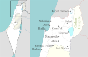
| map = Israel north haifa |
|
|
| location = ], ] |
|
|
| nearest_city = ] |
|
⚫ |
| coordinates = {{coord|33.0728|N|35.2144|E|source:wikidata-and-enwiki-cat-tree_region:IL|display=inline,title}} |
|
|
| area = {{convert|7650|dunam}} |
|
|
| established = 1972 |
|
|
| visitation_num = |
|
|
| visitation_year = |
|
|
| governing_body = ] |
|
|
}} |
|
'''{{lang|he-Latn|Nahal Betzet|italic=no}}''' ({{lang-he|נחל בצת}}, lit. "Betzet stream"; {{lang-ar|وادي كركرة}}, '''{{lang|ar-Latn|Wadi Karkara|italic=no}}'''), is a once-] and now ] in the ], ]. Most of it is part of the ] named for the stream. |
|
'''{{lang|he-Latn|Nahal Betzet|italic=no}}''' ({{lang-he|נחל בצת}}, lit. "Betzet stream"; {{lang-ar|وادي كركرة}}, '''{{lang|ar-Latn|Wadi Karkara|italic=no}}'''), is a once-] and now ] in the ], ]. Most of it is part of the ] named for the stream. |
|
|
|
|
|
==Geography== |
|
==Geography== |
| ⚫ |
] |
|
|
The stream crosses the border from ] into Israel between ] and ], and flows westward, emptying into the ] south of ]. The stream runs along a ] through ] and ], and is fed along its course by ]. Currently, ] (the national water company) pumps the water of the stream's springs, and has been accused of causing the stream to dry up.<ref>{{cite web|url=http://www.inature.info/%D7%A9%D7%9E%D7%95%D7%A8%D7%AA_%D7%A0%D7%97%D7%9C_%D7%91%D7%A6%D7%AA|title=Nahal Betzet Nature Reserve|language=Hebrew|accessdate=2010-10-05|publisher=iNature.info}}</ref> Many caves are formed on the banks of the stream, most notably the arch known as ] (Rainbow Cave). |
|
|
|
|
| Line 10: |
Line 25: |
|
|
|
|
|
Flora in the area includes '']'', '']'', and '']''. |
|
Flora in the area includes '']'', '']'', and '']''. |
|
|
== Gallery == |
|
|
<gallery> |
|
|
File:PikiWiki Israel 87799 betzet river.jpg|Nahal Betzet with the remnants of a pump station built by the founders of Kibbutz Eilon in 1939, which supplied water to the kibbutz until the stream dried up. |
|
|
File:Nahal Betzet (997009157460805171.jpg|Ruins at Nahal Betzet, identified as Khirbet Karkara, an archaeological site in Israel. |
|
|
File:PikiWiki Israel 87795 betzet river.jpg|Sarach Cave, a stalactite cave home to insect-eating bats, where visitors are advised not to disturb the bats. |
|
|
</gallery> |
|
|
|
|
|
==See also== |
|
==See also== |
| Line 22: |
Line 43: |
|
{{Streams of the Galilee}}{{Nature reserves of Israel}} |
|
{{Streams of the Galilee}}{{Nature reserves of Israel}} |
|
{{Authority control}} |
|
{{Authority control}} |
|
|
{{commons category|Nahal Betzet}} |
|
|
|
| ⚫ |
{{Coord|33.0728|N|35.2144|E|source:wikidata-and-enwiki-cat-tree_region:IL|display=title}} |
|
|
|
|
|
|
{{DEFAULTSORT:Betzet, Nahal}} |
|
{{DEFAULTSORT:Betzet, Nahal}} |
Most of the stream is part of a nature reserve that bears its name. The reserve, declared in 1972 covers 7650-dunam and part of it reaches the Israel-Lebanese border. In 2009, 1225 dunams were added to the reserve.
 The arch known as Keshet Cave (Rainbow Cave), the remains of a large collapsed cave
 Nahal Betzet with the remnants of a pump station built by the founders of Kibbutz Eilon in 1939, which supplied water to the kibbutz until the stream dried up.
 Ruins at Nahal Betzet, identified as Khirbet Karkara, an archaeological site in Israel.
 Sarach Cave, a stalactite cave home to insect-eating bats, where visitors are advised not to disturb the bats.