| Revision as of 10:19, 20 December 2024 editHknap1 (talk | contribs)163 edits →Gallery← Previous edit | Revision as of 12:14, 20 December 2024 edit undoBoyTheKingCanDance (talk | contribs)Extended confirmed users, Page movers, Pending changes reviewers173,877 edits Added tags to the page using Page Curation (unreferenced)Tag: PageTriageNext edit → | ||
| Line 1: | Line 1: | ||
| {{unreferenced|date=December 2024}} | |||
| {{Short description|Mountain range in Europe}} | {{Short description|Mountain range in Europe}} | ||
| {{Infobox mountain | {{Infobox mountain | ||
Revision as of 12:14, 20 December 2024
| This article does not cite any sources. Please help improve this article by adding citations to reliable sources. Unsourced material may be challenged and removed. Find sources: "Western Sudetes Foothills" – news · newspapers · books · scholar · JSTOR (December 2024) (Learn how and when to remove this message) |
| Western Sudetes Foothills | |
|---|---|
 Löbau, Upper Lusatian Gefilde with the mountains of the Lusatian Highlands in the background Löbau, Upper Lusatian Gefilde with the mountains of the Lusatian Highlands in the background | |
| Highest point | |
| Peak | Hochstein |
| Elevation | 609 m (1,998 ft) |
| Geography | |
 Divisions of the Sudetes subprovince, Western Sudetes Foothills marked with numbers 1-4, 6, 9, 15 Divisions of the Sudetes subprovince, Western Sudetes Foothills marked with numbers 1-4, 6, 9, 15 | |
| Countries | Czech Republic, Germany and Poland |
| Parent range | Sudetes |
The Western Sudetes Foothills (Polish: Pogórze Zachodniosudeckie) are a geomorphological macroregion in the western part of the Sudetes subprovince on the borders of the Germany, Czech Republic and Poland. It consists of foothills and low mountains, as well as plains and basins in the East Lusatian region.
Subdivision
The Western Sudetes Foothills are divided into following subranges (number indicates its location on the infobox map):
| Number | Name | Location | Highest point |
|---|---|---|---|
| 1 | West Lusatian Hill Country and Uplands |
DE | 609 m (1,998 ft) (Hochstein) |
| 2 | Upper Lusatian Gefilde | DE | |
| 3 | Lusatian Highlands | CZ, DE | 608 m (1,995 ft) (Hrazený) |
| 4 | Eastern Upper Lusatia | DE, CZ, PL | 593 m (1,946 ft) (Prosečský hřeben) |
| 6 | Jizera Foreland | PL, CZ | 572 m (1,877 ft) (Andělský vrch) |
| 9 | Kaczawskie Foothills | PL | 573 m (1,880 ft) (Ostrzyca) |
| 15 | Waldenburg Foothills | PL | 515 m (1,690 ft) (Sas) |
Gallery
-
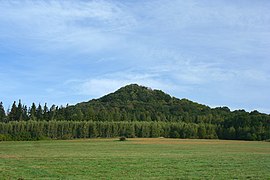
Hochstein, West Lusatian Hill Country
-
 Waterfall in Dresdner Heide, West Lusatian Hill Country
-
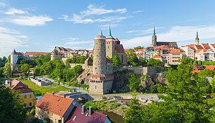
 Bautzen, Upper Lusatian Gefilde
-
Cunewalde with Czorneboh, Lusatian Highlands
-
 Görlitz old town with Landeskrone in the background, Eastern Upper Lusatia
-
 Zittau with the Turów Coal Mine, Eastern Upper Lusatia
-
 Mirsk, Jizera Foreland
-
 Gryfów Śląski, Jizera Foreland
-
 Wleń, Kaczawskie Foothills
-
 Ostrzyca, Kaczawskie Foothills
-
 Książ Castle, Waldenburg Foothills
| Silesia topics | |||||||||||||||||||||||||||||
|---|---|---|---|---|---|---|---|---|---|---|---|---|---|---|---|---|---|---|---|---|---|---|---|---|---|---|---|---|---|
| |||||||||||||||||||||||||||||
| |||||||||||||||||||||||||||||
| |||||||||||||||||||||||||||||
| |||||||||||||||||||||||||||||
This Lower Silesian Voivodeship location article is a stub. You can help Misplaced Pages by expanding it. |
This Czech location article is a stub. You can help Misplaced Pages by expanding it. |