| Revision as of 12:02, 18 April 2005 editOliver Chettle (talk | contribs)5,913 editsmNo edit summary← Previous edit | Revision as of 15:08, 18 April 2005 edit undoRemuel (talk | contribs)8,322 editsm sorted stubNext edit → | ||
| Line 41: | Line 41: | ||
| ---- | ---- | ||
| {{ |
{{UK-geo-stub}} | ||
Revision as of 15:08, 18 April 2005
| Braintree District | |
|---|---|
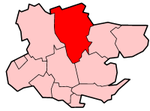
 Shown within Essex | |
| Geography | |
| Status: | District |
| Region: | East of England |
| Admin. County: | Essex |
| Area: - Total |
Ranked 73rd 611.71 km² |
| Admin. HQ: | Braintree |
| ONS code: | 22UC |
| Demographics | |
| Population: - Total (2002 est.) - Density |
Ranked 128th 134,488 220 / km² |
| Ethnicity: | 98.2% White |
| Politics | |
| Braintree District Council http://www.braintree.gov.uk/ | |
| Leadership: | Leader & Cabinet |
| Executive: | Conservative + Independent |
| MPs: | Alan Hurst, Alan Haselhurst |
Braintree is a local government district in the English county of Essex. Its main town is Braintree.
The district was formed on April 1, 1974 by the merger of the urban districts of Braintree and Brocking, Halstead, and Witham and Braintree Rural District and Halstead Rural District.
This United Kingdom location article is a stub. You can help Misplaced Pages by expanding it. |
| Districts of the East of England | ||
|---|---|---|
| Bedfordshire |  | |
| Cambridgeshire | ||
| Essex | ||
| Hertfordshire | ||
| Norfolk | ||
| Suffolk | ||