| Revision as of 05:01, 15 December 2007 editPara (talk | contribs)Extended confirmed users5,236 edits removed map link - service is available through the coordinates← Previous edit | Revision as of 04:41, 31 January 2008 edit undoBrownHairedGirl (talk | contribs)Autopatrolled, Extended confirmed users, File movers, Pending changes reviewers, Rollbackers2,942,733 editsm Reverted edits by Para (talk) to last version by Mats HalldinNext edit → | ||
| Line 19: | Line 19: | ||
| == External links == | == External links == | ||
| * {{cite web | |||
| | url = http://kartor.eniro.se/query?&what=map&mop=yp&imgmode=1&mapstate=9%3B18.079104969095404%3B59.351405812859966%3B0%3B18.075061044466967%3B59.3530987461753%3B18.083148893723838%3B59.34971287954463%3B1200%3B948&mapcomp=%3B%3B%3B%3B%3B%3B%3B%3B%3B%3B%3B%3B%3B%3B0%3B0%3B%3B%3B%3B0&disable_ka=1&disable_multi_company_merge=1&stq=0&pis=0 | |||
| | title = Aerial photo and map of the area | |||
| | publisher = eniro.se | |||
| | accessdate = 2007-06-15 | |||
| | language = Swedish | |||
| }} | |||
| * {{cite web | * {{cite web | ||
| | url = http://www.reich-szyber.com/cgi-bin/.pl?area=portfolio&lang=sv&id=02 | | url = http://www.reich-szyber.com/cgi-bin/.pl?area=portfolio&lang=sv&id=02 | ||
| Line 30: | Line 37: | ||
| {{Stockholm-geo-stub}} | {{Stockholm-geo-stub}} | ||
| {{coor title dms|59|21|6|N|18|04|45|E|region:SE_type |
{{coor title dms|59|21|6|N|18|04|45|E|region:SE_type}} | ||
| ] | ] | ||
Revision as of 04:41, 31 January 2008

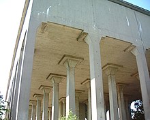
Uggleviksreservoaren (Swedish: The "Uggleviken Reservoir") is a water reservoir located in the forest Lilljansskogen near Lake Uggleviken at Norra Djurgården in north-eastern central Stockholm, Sweden.
The concrete structure, design by architect Paul Hedqvist and built in 1935, is composed of 64 pillars carrying the uninsulated tank crowned by a small lantern. One of the most prominent landmarks in central Stockholm observable from elevated locations kilometres away, the classical structure has a monumentality further amplified by its elevated location in a forest remote from any other buildings. It is one of few remaining, visible traces of the ambitious municipal projects carried through in the early 20th century, still witnessing the restraints and possibilities of casting techniques anticipating pre-stressed concrete and slipform constructions.
References
- Bengt O H Johansson (1999). "Norra Innerstaden". Guide till Stockholms arkitektur (in Swedish) (2nd ed. ed.). Stockholm: Arkitektur förlag. p. 77. ISBN 91 86050-41-9.
{{cite book}}:|edition=has extra text (help)
External links
- "Aerial photo and map of the area" (in Swedish). eniro.se. Retrieved 2007-06-15.
- "Beautiful Sadness" (in Swedish). Reich+Szyber. Retrieved 2007-06-15.
This article about a location in Stockholm County, Sweden is a stub. You can help Misplaced Pages by expanding it. |
59°21′6″N 18°04′45″E / 59.35167°N 18.07917°E / 59.35167; 18.07917
Categories: