| Revision as of 07:34, 22 August 2010 editMjroots (talk | contribs)Autopatrolled, Administrators323,435 edits →Accidents and incidents: typo← Previous edit | Revision as of 19:55, 4 September 2010 edit undoCambridgeBayWeather (talk | contribs)Autopatrolled, Administrators253,295 edits Fix conversion, replaced: disp=output number only}} → disp=output number only|0}} using AWBNext edit → | ||
| Line 11: | Line 11: | ||
| | location = ] | | location = ] | ||
| | elevation-f = 173 | | elevation-f = 173 | ||
| | elevation-m = {{convert|173|ft|disp=output number only}} | | elevation-m = {{convert|173|ft|disp=output number only|0}} | ||
| | coordinates = {{coord|69|21|53|N|081|48|59|W|type:airport_region:CA-NU|display=inline,title|name=Igloolik Airport}} | | coordinates = {{coord|69|21|53|N|081|48|59|W|type:airport_region:CA-NU|display=inline,title|name=Igloolik Airport}} | ||
| | website = | | website = | ||
Revision as of 19:55, 4 September 2010
Airport in Igloolik, Nunavut| Igloolik Airport | |||||||||||
|---|---|---|---|---|---|---|---|---|---|---|---|
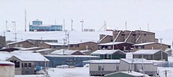
 The airport in Igloolik is located above the town. It is the blue building at the upper left of this photo. November 2005 The airport in Igloolik is located above the town. It is the blue building at the upper left of this photo. November 2005 | |||||||||||
| Summary | |||||||||||
| Airport type | Public | ||||||||||
| Operator | Government of Nunavut | ||||||||||
| Location | Igloolik, Nunavut | ||||||||||
| Elevation AMSL | 173 ft / 53 m | ||||||||||
| Coordinates | 69°21′53″N 081°48′59″W / 69.36472°N 81.81639°W / 69.36472; -81.81639 (Igloolik Airport) | ||||||||||
| Runways | |||||||||||
| |||||||||||
| Statistics (2008) | |||||||||||
| |||||||||||
| Source: Canada Flight Supplement Movements from Statistics Canada. | |||||||||||
Igloolik Airport (IATA: YGT, ICAO: CYGT) is located at Igloolik, Nunavut, Canada, and is operated by the government of Nunavut.
Airlines and destinations
| Airlines | Destinations |
|---|---|
| Canadian North | Hall Beach, Iqaluit, Pond Inlet |
| First Air | Hall Beach, Iqaluit |
Accidents and incidents
- On 29 November 1975, Douglas C-47A C-FOOX of Kenting Atlas Aviation was damaged beyond economic repair at Igloolik Airport.
Gallery
-
 Currently displayed sign. Labeled as an airport of Northwest Territories as sign predates creation of Nunavut in 1999
-
 Igloolik Airport at a distance (blue building). A Canadian North airplane arrives, as All-terrain vehicles and trucks drive up to the airport.
References
- Canada Flight Supplement. Effective 0901Z 16 July 2020 to 0901Z 10 September 2020.
- Aircraft Movement Statistics: Airports Without Air Traffic Control Towers: Annual Report (TP 577)
- Canadian North schedule
- First Air interactive weather/route map
- "C-FOOX Accident description". Aviation Safety Network. Retrieved 21 August 2010.
External links
- Past three hours METARs, SPECI and current TAFs for Igloolik Airport from Nav Canada as available.
| Airports in Canada | |
|---|---|
| By name | |
| By location indicator | |
| By province/territory | |
| By area | |
| National Airports System | |
| Related | |
This article about an airport in Nunavut is a stub. You can help Misplaced Pages by expanding it. |