| Revision as of 12:29, 7 May 2011 view sourceLouperibot (talk | contribs)8,903 editsm r2.5.2) (robot Modifying: cu:Сѣвєрьна Амєрїка← Previous edit | Revision as of 18:23, 11 May 2011 view source Screaming locos (talk | contribs)8 edits →HistoryNext edit → | ||
| Line 34: | Line 34: | ||
| Alfred E. Hudd proposed a theory in 1908 that the continents are named after a Welsh merchant named ] from Bristol, who is believed to have financed ]'s voyage of discovery from England to Newfoundland in 1497. A minutely explored belief that has been advanced is that America was named for a Spanish sailor bearing the ancient ] name of 'Amairick'. Another is that the name is rooted in a ] language.<ref name="Cohen"/> | Alfred E. Hudd proposed a theory in 1908 that the continents are named after a Welsh merchant named ] from Bristol, who is believed to have financed ]'s voyage of discovery from England to Newfoundland in 1497. A minutely explored belief that has been advanced is that America was named for a Spanish sailor bearing the ancient ] name of 'Amairick'. Another is that the name is rooted in a ] language.<ref name="Cohen"/> | ||
| ==History== hello every body this site is now afficially closed | |||
| ==History== | |||
| {{Main|History of North America}} | {{Main|History of North America}} | ||
| ===Geologic history=== | ===Geologic history=== | ||
| North America is the source of much of what humanity knows about ] periods.<ref name="dinopedia-american" /> The geographic area that would later become the United States has been the source of more varieties of ]s than any other modern country.<ref name="dinopedia-american" /> According to ] Peter Dodson, this is primarily due to stratigraphy, climate and geography, human resources, and history.<ref name="dinopedia-american" /> Much of the ] is represented by exposed outcrops in the many arid regions of the continent.<ref name="dinopedia-american">Dodson, Peter (1997). "American Dinosaurs." ''Encyclopedia of Dinosaurs''. Edited by Phillip J. Currie and Kevin Padian. Academic Press. p. 10-13.</ref> The most significant ] ] dinosaur-bearing fossil deposit in North America is the ] of the western United States.<ref name="jurassicdistribution">Weishampel, David B; et al (2004). "Dinosaur distribution (Late Jurassic, North America)." In: Weishampel, David B.; Dodson, Peter; and Osmólska, Halszka (eds.): The Dinosauria, 2nd, Berkeley: University of California Press. Pp. 543–545. ISBN 0-520-24209-2.</ref> | North America is the source of much of what humanity knows about ] periods.<ref name="dinopedia-american" /> The geographic area that would later become the United States has been the source of more varieties of ]s than any other modern country.<ref name="dinopedia-american" /> According to ] Peter Dodson, this is primarily due to stratigraphy, climate and geography, human resources, and history.<ref name="dinopedia-american" /> Much of the ] is represented by exposed outcrops in the many arid regions of the continent.<ref name="dinopedia-american">Dodson, Peter (1997). "American Dinosaurs." ''Encyclopedia of Dinosaurs''. Edited by Phillip J. Currie and Kevin Padian. Academic Press. p. 10-13.</ref> The most significant ] ] dinosaur-bearing fossil deposit in North America is the ] of the western United States.<ref name="jurassicdistribution">Weishampel, David B; et al (2004). "Dinosaur distribution (Late Jurassic, North America)." In: Weishampel, David B.; Dodson, Peter; and Osmólska, Halszka (eds.): The Dinosauria, 2nd, Berkeley: University of California Press. Pp. 543–545. ISBN 0-520-24209-2.</ref> | ||
Revision as of 18:23, 11 May 2011
"North American" redirects here. For other uses, see North American (disambiguation).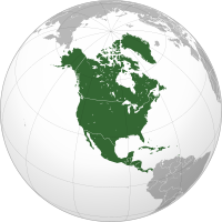 | |
| Area | 24,709,000 km (9,540,000 sq mi) |
|---|---|
| Population | 528,720,588 (2008, 4th) |
| Population density | 22.9/km (59.3/sq mi) |
| Demonym | North American, American |
| Countries | 23 |
| Dependencies | see List of North American countries |
| Languages | Spanish, English, French, Dutch and many others |
| Time zones | UTC-10 to UTC |
| Largest cities | List of cities |
North America (Template:Lang-es or Norteamérica; Template:Lang-fr) is the northern continent of the Americas, situated in the Earth's northern hemisphere and in the western hemisphere. It is bordered on the north by the Arctic Ocean, on the east by the North Atlantic Ocean, on the southeast by the Caribbean Sea, and on the west by the North Pacific Ocean. South America lies to the southeast of the continent.
North America covers an area of about 24,709,000 square kilometers (9,540,000 square miles), about 4.8% of the planet's surface or about 16.5% of its land area. As of July 2008, its population was estimated at nearly 529 million people. It is the third-largest continent in area, following Asia and Africa, and the fourth in population after Asia, Africa, and Europe.
Etymology

The Americas are usually accepted as having been named after the Italian explorer Amerigo Vespucci by the German cartographers Martin Waldseemüller and Matthias Ringmann. Vespucci, who explored South America between 1497 and 1502, was the first European to suggest that the Americas were not the East Indies, but a different landmass previously unknown by Europeans. In 1507, Waldseemüller produced a world map, in which he placed the word "America" on the continent of South America, in the middle of what is today Brazil. He explained the rationale for the name in the accompanying book Cosmographiae Introductio,
- ab Americo inventore ... quasi Americi terram sive Americam (from Americus the discoverer ... as if it were the land of Americus, thus America).
For Waldseemüller, no one should object to the naming of the land after its discoverer. He used the Latinized version of Vespucci's name (Americus Vespucius), but in its feminine form "America", following the examples of "Europa" and "Asia".
Later, when other mapmakers added North America, they extended the original name to it as well: in 1538, Gerard Mercator used the name America to all of the Western Hemisphere on his world map.
Some argue that the convention is to use the surname for naming discoveries except in the case of royalty and so a derivation from "Amerigo Vespucci" could be problematic. Ricardo Palma (1949) proposed a derivation from the "Amerrique" mountains of Central America—Vespucci was the first to discover South America and the Amerrique mountains of Central America, which connected his discoveries to those of Christopher Columbus.
Alfred E. Hudd proposed a theory in 1908 that the continents are named after a Welsh merchant named Richard Amerike from Bristol, who is believed to have financed John Cabot's voyage of discovery from England to Newfoundland in 1497. A minutely explored belief that has been advanced is that America was named for a Spanish sailor bearing the ancient Visigothic name of 'Amairick'. Another is that the name is rooted in a Native American language.
==History== hello every body this site is now afficially closed
Main article: History of North AmericaGeologic history
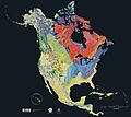
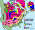
North America is the source of much of what humanity knows about geologic time periods. The geographic area that would later become the United States has been the source of more varieties of dinosaurs than any other modern country. According to paleontologist Peter Dodson, this is primarily due to stratigraphy, climate and geography, human resources, and history. Much of the Mesozoic Era is represented by exposed outcrops in the many arid regions of the continent. The most significant Late Jurassic dinosaur-bearing fossil deposit in North America is the Morrison Formation of the western United States.
Prehistory
Scientists have several theories as to the origins of the early human population of North America. The indigenous peoples of North America themselves have many creation myths, by which they assert that they have been present on the land since its creation.
Before contact with Europeans, the natives of North America were divided into many different polities, from small bands of a few families to large empires. They lived in several "culture areas", which roughly correspond to geographic and biological zones and give a good indication of the main lifeway or occupation of the people who lived there (e.g. the Bison hunters of the Great Plains, or the farmers of Mesoamerica). Native groups can also be classified by their language family (e.g. Athapascan or Uto-Aztecan). It is important to note that peoples with similar languages did not always share the same material culture, nor were they always allies.
Scientists believe that the Inuit people of the high Arctic came to North America much later than other native groups, as evidenced by the disappearance of Dorset culture artifacts from the archaeological record, and their replacement by the Thule people.
During the thousands of years of native inhabitation on the continent, cultures changed and shifted. Archaeologists often name different cultural groups they discover after the site where they were first found. One of the oldest cultures yet found is the Clovis culture of modern New Mexico. A more recent example is the group of related cultures called the Mound builders (e.g. the Fort Walton Culture), found in the Mississippi river valley. They flourished from 300 BC to the 150s AD.
The more southern cultural groups of North America were responsible for the domestication of many common crops now used around the world, such as tomatoes and squash. Perhaps most importantly they domesticated one of the world's major staples, maize (corn).
History
As a result of the development of agriculture in the south, many important cultural advances were made there. For example, the Maya civilization developed a writing system, built huge pyramids and temples, had a complex calendar, and developed the concept of zero around 400 CE, a few hundred years after the Mesopotamians. The Mayan culture was still present when the Spanish arrived in Central America, but political dominance in the area had shifted to the Aztec Empire further north.
Upon the arrival of the Europeans in the "New World", Native American population declined substantially, primarily due to the introduction of European diseases to which the Native Americans lacked immunity. Native peoples found their culture changed drastically. As such, their affiliation with political and cultural groups changed as well, several linguistic groups went extinct, and others changed quite quickly. The names and cultures that Europeans recorded for the natives were not necessarily the same as the ones they had used a few generations before, or the ones in use today.
Geography and extent
Further information: Geography of North America
North America occupies the northern portion of the landmass generally referred to as the New World, the Western Hemisphere, the Americas, or simply America (which is sometimes considered a single continent and North America a subcontinent). North America's only land connection to South America is at the Isthmus of Panama. The continent is generally delimited on the southeast by the Darién watershed along the Colombia-Panama border, or at the Panama Canal; according to other sources, its southern limit is the Isthmus of Tehuantepec, Mexico, with Central America tapering and extending southeastward to South America. Before the Central American isthmus was raised, the region had been underwater. The islands of the West Indies delineate a submerged former land bridge, which had connected North America and South America via what are now Florida and Venezuela. Much of North America is on the North American Plate.
The continental coastline is long and irregular. The Gulf of Mexico is the largest body of water indenting the continent, followed by Hudson Bay. Others include the Gulf of Saint Lawrence and the Gulf of California.
There are numerous islands off the continent’s coasts: principally, the Arctic Archipelago, the Bahamas, Turks & Caicos, the Greater and Lesser Antilles, the Aleutian Islands (some of which are in the eastern hemisphere proper), the Alexander Archipelago, the many thousand islands of the British Columbia Coast, and Newfoundland. Greenland, a self-governing Danish island, and the world's largest, is on the same tectonic plate (the North American Plate) and is part of North America geographically. In a geologic sense, Bermuda is not part of the Americas, but an oceanic island which was formed on the fissure of the Mid-Atlantic Ridge over 100 million years ago. The nearest landmass to it is Cape Hatteras, North Carolina. However, Bermuda is often thought of as part of North America, especially given its historical, political and cultural ties to Virginia and other parts of the continent.
Physical geography

The vast majority of North America is on the North American Plate. Parts of California and western Mexico form the partial edge of the Pacific Plate, with the two plates meeting along the San Andreas fault. The southernmost portion of the continent and much of the West Indies lie on the Caribbean Plate, whereas the Juan de Fuca and Cocos plates border the North American Plate on its western frontier.
The continent can be divided into four great regions (each of which contains many subregions): the Great Plains stretching from the Gulf of Mexico to the Canadian Arctic; the geologically young, mountainous west, including the Rocky Mountains, the Great Basin, California and Alaska; the raised but relatively flat plateau of the Canadian Shield in the northeast; and the varied eastern region, which includes the Appalachian Mountains, the coastal plain along the Atlantic seaboard, and the Florida peninsula. Mexico, with its long plateaus and cordilleras, falls largely in the western region, although the eastern coastal plain does extend south along the Gulf.
The western mountains are split in the middle and into the main range of the Rockies and the coast ranges in California, Oregon, Washington, and British Columbia with the Great Basin—a lower area containing smaller ranges and low-lying deserts—in between. The highest peak is Denali in Alaska.
The United States Geographical Survey states that the geographic center of North America is "6 miles west of Balta, Pierce County, North Dakota" at approximately 48°10′N 100°10′W / 48.167°N 100.167°W / 48.167; -100.167, approximately 15 miles (25 km) from Rugby, North Dakota. The USGS further states that “No marked or monumented point has been established by any government agency as the geographic center of either the 50 States, the conterminous United States, or the North American continent.” Nonetheless, there is a 15-foot (4.5 m) field stone obelisk in Rugby claiming to mark the center.
Human geography
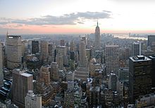

The prevalent languages in North America are English, Spanish, and French. The term Anglo-America is used to refer to the anglophone countries of the Americas: namely Canada (where English and French are co-official) and the United States, but also sometimes Belize and parts of the Caribbean. Latin America refers to the other areas of the Americas (generally south of the United States) where the Romance languages, derived from Latin, of Spanish and Portuguese (but French speaking countries are not usually included) predominate: the other republics of Central America (but not always Belize), part of the Caribbean (not the Dutch, English or French speaking areas), Mexico, and most of South America (except Guyana, Suriname, French Guiana (FR), and The Falkland Islands (UK)).
The French language has historically played a significant role in North America and now retains a distinctive presence in some regions. Canada is officially bilingual. French is the official language of the Province of Quebec, where 95% of the people speak it as either their first or second language, and it is co-official with English in the Province of New Brunswick. Other French-speaking locales include the Province of Ontario (the official language is English, but there is an estimated 600,000 Franco-Ontarians), the Province of Manitoba (co-official as de-jure with English), the French West Indies and Saint-Pierre et Miquelon, as well as the U.S. state of Louisiana, where French is also an official language. Haiti is included with this group based on historical association but Haitians speak both Creole and French. Similarly, French and French Antillean Creole is spoken in Saint Lucia and the Commonwealth of Dominica alongside English.
Socially and culturally, North America presents a well-defined entity. Canada and the United States have a similar culture and similar traditions as a result of both countries being former British colonies. A common cultural and economic market has developed between the two nations because of the strong economic and historical ties. Spanish-speaking North America shares a common past as former Spanish colonies. In Mexico and the Central American countries where civilizations like the Maya developed, indigenous people preserve traditions across modern boundaries. Central American and Spanish-speaking Caribbean nations have historically had more in common due to geographical proximity and the fact that they won independence from Spain.
Northern Mexico, particularly in the cities of Monterrey, Tijuana, Ciudad Juárez, and Mexicali, is strongly influenced by the culture and way of life of the U.S. Immigration to the United States and Canada remains a significant attribute of many nations close to the southern border of the U.S. The Anglophone Caribbean states have witnessed the decline of the British Empire and its influence on the region, and its replacement by the economic influence of northern North America. In the Anglophone Caribbean this influence is partly due to the relatively small populations (less than 200,000) of the majority of English-speaking Caribbean countries, and the fact that many of these countries now have expatriate diasporas living abroad that are larger than those remaining at home.
Economically, Canada and the United States are the wealthiest and most developed nations in the continent, followed by Mexico, a newly industrialized country. The countries of Central America and the Caribbean are at various levels of economic and human development. For example, small Caribbean island-nations such as Barbados, Trinidad and Tobago and Antigua and Barbuda have a higher GDP (PPP) per capita than Mexico due to their smaller populations. Panama and Costa Rica have a significantly higher Human Development Index and GDP than the rest of the Central American nations.
Demographically, North America is a racially and ethnically diverse continent. Its three main racial groups are Whites, Mestizos and Blacks. There is a significant minority of Native Americans and Asians among other less numerous groups.
Economy
The most influential trade blocs are the Caribbean Community and Common Market (CARICOM), the North American Free Trade Agreement (NAFTA), and the recently signed Central American Free Trade Agreement (CAFTA) — the latter being an example of the economic integration sought by the nations of this sub-region as a way to improve their financial status.
Infrastructure
Communications
Main article: North American Numbering PlanMany of the nations of North America cooperate together on a shared telephone system known as the North American Numbering Plan (NANP) which is an integrated telephone numbering plan of 24 countries and territories: the United States and its territories, Canada, Bermuda, and 16 Caribbean nations.
Countries and territories
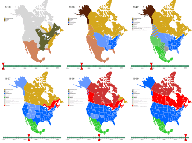
over North America,
1750–2008
North America is often divided into subregions but no universally accepted divisions exist. Central America comprises the southern region of the continent, but its northern terminus varies between sources. Geophysically, the region starts at the Isthmus of Tehuantepec in Mexico (namely the Mexican states of Campeche, Chiapas, Tabasco, Quintana Roo, and Yucatán). The United Nations geoscheme includes Mexico in Central America; conversely, the European Union excludes both Mexico and Belize from the area. Geopolitically however, Mexico is usually considered a part of the North American region.
Northern America is used to refer to the northern countries and territories of North America: Canada, the United States, Greenland, Bermuda, and St. Pierre and Miquelon. They are often considered distinct from the southern portion of the Americas, which largely comprise Latin America. The term Middle America is sometimes used to collectively refer to Mexico, the nations of Central America, and the Caribbean.
| Country or territory | Area (km²) |
Population (2008 est.) |
Population density (per km²) |
Capital |
|---|---|---|---|---|
| North America | ||||
| 54 | 65,000 | 1203.7 | Hamilton | |
| 9,984,670 | 33,573,000 | 3.4 | Ottawa | |
| 2,166,086 | 57,000 | 0.026 | Nuuk | |
| 1,964,375 | 112,322,757 | 57.1 | Mexico City | |
| 242 | 6,000 | 24.8 | Saint-Pierre | |
| 9,629,091 | 314,659,000 | 32.7 | Washington, D.C. | |
| Caribbean | ||||
| 91 | 15,000 | 164.8 | The Valley | |
| 442 | 88,000 | 199.1 | St. John's | |
| 180 | 107,000 | 594.4 | Oranjestad | |
| 13,943 | 342,000 | 24.5 | Nassau | |
| 430 | 256,000 | 595.3 | Bridgetown | |
| 294 | 12,093 | 41.1 | Kralendijk | |
| 151 | 23,000 | 152.3 | Road Town | |
| 264 | 56,000 | 212.1 | George Town | |
| 109,886 | 11,204,000 | 102.0 | Havana | |
| 444 | 140,794 | 317.1 | Willemstad | |
| 751 | 67,000 | 89.2 | Roseau | |
| 48,671 | 10,090,000 | 207.3 | Santo Domingo | |
| 344 | 104,000 | 302.3 | St. George's | |
| 1,628 | 401,784 | 246.7 | Basse-Terre | |
| 27,750 | 10,033,000 | 361.5 | Port-au-Prince | |
| 10,991 | 2,719,000 | 247.4 | Kingston | |
| 1,128 | 397,693 | 352.6 | Fort-de-France | |
| 102 | 6,000 | 58.8 | Plymouth; Brades | |
| 8,870 | 3,982,000 | 448.9 | San Juan | |
| 13 | 1,537 | 118.2 | The Bottom | |
| 21 | 7,448 | 354.7 | Gustavia | |
| 261 | 52,000 | 199.2 | Basseterre | |
| 539 | 172,000 | 319.1 | Castries | |
| 54 | 29,820 | 552.2 | Marigot | |
| 389 | 109,000 | 280.2 | Kingstown | |
| 21 | 2,739 | 130.4 | Oranjestad | |
| 34 | 40,009 | 1176.7 | Philipsburg | |
| 5,130 | 1,339,000 | 261.0 | Port of Spain | |
| 948 | 33,000 | 34.8 | Cockburn Town | |
| 347 | 110,000 | 317.0 | Charlotte Amalie | |
| Central America | ||||
| 22,966 | 307,000 | 13.4 | Belmopan | |
| 51,100 | 4,579,000 | 89.6 | San José | |
| 21,041 | 6,163,000 | 293.0 | San Salvador | |
| 108,889 | 14,027,000 | 128.8 | Guatemala City | |
| 112,492 | 7,466,000 | 66.4 | Tegucigalpa | |
| 130,373 | 5,743,000 | 44.1 | Managua | |
| 75,417 | 3,454,000 | 45.8 | Panama City | |
| Total | 24,500,995 | 541,720,440 | 22.9 | |
The term North America may mean different things to different people in the world according to the context. Usage other than that of the entire continent includes:
- In English, North America may be used to refer to the United States and Canada together. Alternatively, usage often includes Mexico (as with North American Free Trade Agreement) and other entities.
- In Latin America, Spain, Portugal, and some other parts of Europe, North America usually designates a subcontinent (subcontinente in Spanish) of the Americas containing Canada, the United States, and Mexico, and often Greenland, Saint Pierre et Miquelon, and Bermuda.
Historical toponymy
North America, in whole or in part, has been historically referred to by other names:
- Spanish North America (New Spain) was often referred to as Northern America, and this was the first official name given to Mexico.
- The Spanish called North America Florida, which eventually became more focused on its present location.
- The English called their portion of North America Virginia. The name Virginia was first applied by Queen Elizabeth I and Sir Walter Raleigh in 1584. John Dee pushed to call it Atlantis (inspired by Plato).
- The northern part of North America was often referred to as Norumbega.
- The northeastern part of what would become the United States was named New England in 1616 in John Smith's book of that year.
- Western North America was named Nova Albion by Francis Drake as he repaired his boat (Golden Hind) a short distance north of present day San Francisco.
- Areas of past British control were called British North America.
- Regions under control of the Hudson's Bay Company was called Rupert's Land, which eventually made up a largbeg portion of the Dominion of Canada, the modern country of Canada.
- Outside of North America, going into the twentieth century, the whole American continent (North, Central and South America as well as the Caribbean) was referred simply as "America", one of the "Five Continents" (the other four being, Africa, Europe, Asia and Oceania).
See also
Main article: Outline of North America|
Organizations and agreements: |
References
3External links
- commons:Category:North America
- "North America"/"Central America". Encyclopædia Britannica. 2006. Chicago, Encyclopædia Britannica, Inc.
- UN Statistics Division: Composition of macro geographical (continental) regions, geographical sub-regions, and selected economic and other groupings
- GeoHive: The population of continents, regions and countries
- Houghton Mifflin Company, "North America"
- Council on Hemispheric Affairs
- Consortium for North American Higher Education Collaboration
- Crystal Reference Encyclopedia, "North America"
