| Revision as of 18:49, 30 March 2012 editPenman47 (talk | contribs)7 editsNo edit summary← Previous edit | Revision as of 18:53, 30 March 2012 edit undoPenman47 (talk | contribs)7 editsNo edit summaryNext edit → | ||
| Line 37: | Line 37: | ||
| <gallery> | <gallery> | ||
| File:Unique |
File:Unique Joint arrangement at Crystal Springs Dam.jpg|Example of unique joint design for Crystal Springs Dam | ||
| File:Completed Crystal Springs Dam.jpg|Completed Crystal Springs Dam | File:Completed Crystal Springs Dam.jpg|Completed Crystal Springs Dam | ||
| <gallery> | <gallery> | ||
Revision as of 18:53, 30 March 2012
For the dam in Arkansas, see National Register of Historic Places listings in Arkansas. Dam| Crystal Springs Dam | |
|---|---|
 | |
| Coordinates | 37°31′43″N 122°21′44″W / 37.5285°N 122.3622°W / 37.5285; -122.3622 |
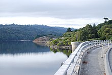
Crystal Springs Dam is a gravity dam constructed across the San Mateo Creek, impounding water to form the Lower Crystal Springs Reservoir in San Mateo County, California.
The structure was completed in 1888, and has survived both the 1906 San Francisco earthquake and the 1989 Loma Prieta earthquake — despite its location directly on the San Andreas Fault.
The dam has a road running over it and forms the trailhead of the popular Sawyer Camp Trail.
Currently the dam is undergoing renovations. The dam is being raised to increase the water storage capacity of the reservoir as well as other changes. The roadway on top of the dam is closed.
The Crystal Springs Dam was designed by Herman Schussler Chief Engineer of the Spring Valley Water Company. The concrete dam was constructed by using large blocks poured separately and allowed to set before adjoining blocks were poured. The unique feature of this dam is the fact that none of the horizontal or vertical joints match up. Mr. Schussler was also very demanding that the concrete be batched in the exact proportions of his mix design. Although this dam was erected about 100 yards east of the San Andreas fault line and was subject to severe shaking it did not leak a drop. The attached photographs show the unique joint configuration and the completed dam.
<gallery> File:Unique Joint arrangement at Crystal Springs Dam.jpg|Example of unique joint design for Crystal Springs Dam File:Completed Crystal Springs Dam.jpg|Completed Crystal Springs Dam <gallery>
References
- Department of Water Resources (2009). "Station Meta Data: Lower Crystal Springs Dam (CRY)". California Data Exchange Center. State of California. Retrieved 2009-04-01.
- "Crystal Spring Dam". Geographic Names Information System. United States Geological Survey, United States Department of the Interior. 19-Jan-1981. Retrieved 2009-06-11.
{{cite encyclopedia}}: Check date values in:|date=(help) - U.S. Geological Survey (24 November 2003). "Crystal Springs Reservoir". U.S. Department of the Interior. Retrieved 2009-04-01.
- Ron Horii (1 October 2003). "Bay Area Biking: Crystal Springs Trails". Bay Area Back Page. Retrieved 2009-04-01.
Further reading
- Postel, Mitchell (1994). San Mateo: A Centennial History. San Francisco: Scottwall Associates, Publishers. ISBN 0942087089.
{{cite book}}: Cite has empty unknown parameter:|coauthors=(help)
External links
This San Mateo County, California-related article is a stub. You can help Misplaced Pages by expanding it. |

